Report on Karkar (Papua New Guinea) — 20 February-26 February 2013
Smithsonian Institution / US Geological Survey
Weekly Volcanic Activity Report, 20 February-26 February 2013
Managing Editor: Sally Sennert.
Please cite this report as:
Global Volcanism Program, 2013. Report on Karkar (Papua New Guinea) (Sennert, S, ed.). Weekly Volcanic Activity Report, 20 February-26 February 2013. Smithsonian Institution and US Geological Survey.
Karkar
Papua New Guinea
4.647°S, 145.976°E; summit elev. 1839 m
All times are local (unless otherwise noted)
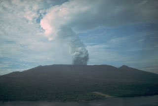
Based on analyses of satellite imagery and wind data, the Darwin VAAC reported that on 26 February an ash plume from Karkar rose to an altitude of 9.1 km (30,000 ft) a.s.l.
Geological Summary. Karkar is a 19 x 25 km forest-covered island that is truncated by two nested summit calderas. The 5.5 km outer caldera was formed during one or more eruptions, the last of which occurred 9,000 years ago. The steep-walled 300-m-deep, 3.2 km diameter, inner caldera was formed sometime between 1,500 and 800 years ago. Cones are present on the N and S flanks of this basaltic-to-andesitic volcano; a linear array of small cones extends from the northern rim of the outer caldera nearly to the coast. Recorded eruptions date back to 1643 from Bagiai, a pyroclastic cone constructed within the inner caldera, the floor of which is covered by young, mostly unvegetated andesitic lava flows.

