Report on Oraefajokull (Iceland) — 9 May-15 May 2018
Smithsonian Institution / US Geological Survey
Weekly Volcanic Activity Report, 9 May-15 May 2018
Managing Editor: Sally Sennert.
Please cite this report as:
Global Volcanism Program, 2018. Report on Oraefajokull (Iceland) (Sennert, S, ed.). Weekly Volcanic Activity Report, 9 May-15 May 2018. Smithsonian Institution and US Geological Survey.
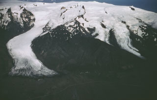
Oraefajokull
Iceland
64°N, 16.65°W; summit elev. 2010 m
All times are local (unless otherwise noted)
On 4 May, the Icelandic Met Office reduced the Aviation Color Code at Öræfajökull from Yellow to Green due to signs of reduced activity. Since September 2017 there has been less earthquake activity, stable hydrological and geochemical measurements, and reduced geothermal heat output. There has been possible minor ongoing inflation, but no signs of an imminent eruption.
Geological Summary. Öræfajökull, Iceland's highest peak, is a broad glacier-clad central volcano at the SE end of the Vatnajökull icecap. A 4 x 5 km subglacial caldera truncates the summit of the dominantly basaltic and rhyolitic volcano. The extensive summit icecap is drained through deep glacial valleys dissecting the SW-to-SE flanks. It is the largest-volume volcano in Iceland, and was mostly constructed during Pleistocene glacial and interglacial periods. Holocene activity has been dominated by explosive summit eruptions, although flank lava effusions have also occurred. A major silicic eruption in 1362 CE was Iceland's largest historical explosive eruption. It and another eruption during 1727-28 were accompanied by major jökulhlaups (glacier outburst floods) that caused property damage and fatalities.