Report on Akan (Japan) — 28 November-4 December 2018
Smithsonian Institution / US Geological Survey
Weekly Volcanic Activity Report, 28 November-4 December 2018
Managing Editor: Sally Sennert.
Please cite this report as:
Global Volcanism Program, 2018. Report on Akan (Japan) (Sennert, S, ed.). Weekly Volcanic Activity Report, 28 November-4 December 2018. Smithsonian Institution and US Geological Survey.
Akan
Japan
43.384°N, 144.013°E; summit elev. 1499 m
All times are local (unless otherwise noted)
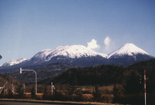
JMA reported that the number of earthquakes with shallow hypocenters and epicenters near Ponmachineshiri Crater, a summit crater of Me-Akan (also known as Meakan-dake, which means Meakan Peak) of the Akan volcanic complex, increased at 1800 on 20 November. Another seismic increase occurred on 23 November, in number and amplitude of events, prompting JMA to raise the Alert Level to 2 (the second lowest level on a 5-level scale).
Geological Summary. Akan is a 13 x 24 km caldera located immediately SW of Kussharo caldera in eastern Hokkaido. The elongated, irregular outline of the caldera rim reflects its incremental formation during major explosive eruptions from the early to mid-Pleistocene. There are four post-caldera stratovolcanoes, three at the SW end of the caldera and the other on the NE side. Conical Oakandake was frequently active during the Holocene. The 1-km-wide Nakamachineshiri crater of Meakandake was formed during a major pumice-and-scoria eruption about 13,500 years ago. The Meakandake group, composed of nine overlapping cones E of Lake Akan, has produced mild phreatic eruptions since the beginning of the 19th century. The main cone of Meakandake proper has a triple crater at its summit. Although recorded eruptions at Meakandake have consisted of minor phreatic explosions, four major magmatic eruptions with pyroclastic flows have also occurred during the Holocene.