
Smithsonian Institution / US Geological Survey
Weekly Volcanic Activity Report, 30 October-5 November 2002
Managing Editor: Gari Mayberry
Please cite this report as:
Global Volcanism Program, 2002. Report on Reventador (Ecuador) (Mayberry, G, ed.). Weekly Volcanic Activity Report, 30 October-5 November 2002. Smithsonian Institution and US Geological Survey. https://volcano.si.edu/showreport.cfm?gvpvar=GVP.WVAR20021030-352010
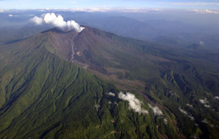
After 26 years with no explosive activity, a large eruption began at Reventador on 3 November that sent pyroclastic flows down the volcano's flanks. Based on seismic data and observations made by people near Reventador, IG reported that the first pyroclastic flows produced from the eruption occurred on the 3rd around 0900. Then, during 1000-1900 continuous tremor was recorded that may have been associated with continuous ash emissions and small explosions. Between 2000 on the 3rd and 0100 on the 4th, there was an increase in the amount and intensity of the tremor. After 0100 the activity level decreased, but a pulse of activity occurred between 0200 and 0300. A new cycle of activity began during 0700-0800. Small-to-moderate explosions occurred during the day and small pyroclastic flows descended the volcano's flanks. On the morning of the 5th explosive sounds were not heard, no ash fell in towns near the volcano, and meteorological clouds obscured Reventador. In addition, seismicity was low, but some small earthquakes and low-amplitude volcanic tremor occurred.
According to the Washington VAAC, the first eruption on 3 November produced an ash cloud that reached a height of ~16.8 km a.s.l. Subsequent explosions generated more ash clouds and satellite imagery showed discrete ash clouds on the 5th; a thin area of ash at ~16.8 km a.s.l. was located over S Colombia and N Brazil moving E, and a thicker ash cloud drifted W over the Pacific Ocean towards the Galapagos Islands at a height of ~10.7 km. In addition, a nearly stationary area of ash was observed over the Pacific Ocean off the coast of Ecuador at a height of ~9.1 km a.s.l.
According to OCHA, pyroclastic flows on the 3rd reached the Baeza-Lumbaqui highway, blocking inter-city traffic. Ash fell in the towns of Baeza, Cayambe, Yaruqui, El Quinche, Tumbaco, Pifo, Sangoqui, and Quito, Ecuador's capital ~70 km W of Reventador. Quito was paralyzed by ash fall; schools and businesses were closed, residents were told to remain indoors, and all operations at the Mariscal Sucre airport in Quito were suspended. The approximately 3,000 people living in towns at the base of the volcano were evacuated and no deaths or injuries were attributed to volcanic activity.
Sources: Instituto Geofísico-Escuela Politécnica Nacional (IG-EPN), UN Office for the Coordination of Humanitarian Affairs (OCHA), Washington Volcanic Ash Advisory Center (VAAC), El Universo, El Comercio
Geological Summary. Volcán El Reventador is the most frequently active of a chain of Ecuadorian volcanoes in the Cordillera Real, well east of the principal volcanic axis. The forested, dominantly andesitic stratovolcano has 4-km-wide avalanche scarp open to the E formed by edifice collapse. A young, unvegetated, cone rises from the amphitheater floor to a height comparable to the rim. It has been the source of numerous lava flows as well as explosive eruptions visible from Quito, about 90 km ESE. Frequent lahars in this region of heavy rainfall have left extensive deposits on the scarp slope. The largest recorded eruption took place in 2002, producing a 17-km-high eruption column, pyroclastic flows that traveled up to 8 km, and lava flows from summit and flank vents.


 Reventador