
Smithsonian Institution / US Geological Survey
Weekly Volcanic Activity Report, 8 January-14 January 2003
Managing Editor: Gari Mayberry
Please cite this report as:
Global Volcanism Program, 2003. Report on Reventador (Ecuador) (Mayberry, G, ed.). Weekly Volcanic Activity Report, 8 January-14 January 2003. Smithsonian Institution and US Geological Survey. https://volcano.si.edu/showreport.cfm?gvpvar=GVP.WVAR20030108-352010
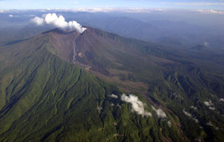
During 10-14 January, volcanic and seismic activity were relatively low at Reventador. On the 10th several lahars traveled down the Marquer and Reventador rivers. Lava flows continued to slowly advance and steam plumes were seen rising above the volcano.
Source: Instituto Geofísico-Escuela Politécnica Nacional (IG-EPN)
Geological Summary. Volcán El Reventador is the most frequently active of a chain of Ecuadorian volcanoes in the Cordillera Real, well east of the principal volcanic axis. The forested, dominantly andesitic stratovolcano has 4-km-wide avalanche scarp open to the E formed by edifice collapse. A young, unvegetated, cone rises from the amphitheater floor to a height comparable to the rim. It has been the source of numerous lava flows as well as explosive eruptions visible from Quito, about 90 km ESE. Frequent lahars in this region of heavy rainfall have left extensive deposits on the scarp slope. The largest recorded eruption took place in 2002, producing a 17-km-high eruption column, pyroclastic flows that traveled up to 8 km, and lava flows from summit and flank vents.


 Reventador