Report on Gareloi (United States) — 31 March-6 April 2021
Smithsonian Institution / US Geological Survey
Weekly Volcanic Activity Report, 31 March-6 April 2021
Managing Editor: Sally Sennert.
Please cite this report as:
Global Volcanism Program, 2021. Report on Gareloi (United States) (Sennert, S, ed.). Weekly Volcanic Activity Report, 31 March-6 April 2021. Smithsonian Institution and US Geological Survey.
Gareloi
United States
51.79°N, 178.794°W; summit elev. 1573 m
All times are local (unless otherwise noted)
AVO reported that a loss of operation and communication with all seismic stations on Gareloi was likely due to snow cover. Both the Aviation Color Code and the Volcano Alert Level were changed to Unassigned, reflecting the lack of this data to detect unrest. The observatory noted that regional infrasound networks, lightning detection, and satellite images will be used to monitor and detected unrest.
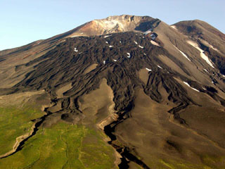
Geological Summary. The 8 x 10 km Gareloi Island, the northernmost volcano of the Delarof Group at the western end of the Andreanof Islands, consists of a stratovolcano with two summits and a prominent SE-trending fissure. The fissure was formed during an eruption in 1929 and extends from the southern summit to the sea. Steep sea cliffs that are cut into rocks of an older, eroded center are found on the SW coast, and submarine deposits of three debris avalanches produced by edifice collapse are found offshore. Young lava flows cover the older volcano from the summit to the coast along three broad axes trending NW, ENE, and S. The 1929 eruption originated from 13 craters along a 4-km-long fissure. Phreatic explosions were followed by the ejection of glassy pumice, lapilli, scoria, and older blocks, as well as by the emission of four short, steep lava flows, one of which reached the SE coast.
Source: US Geological Survey Alaska Volcano Observatory (AVO)