Report on Purace (Colombia) — 3 January-9 January 2024
Smithsonian Institution / US Geological Survey
Weekly Volcanic Activity Report, 3 January-9 January 2024
Managing Editor: Sally Sennert.
Please cite this report as:
Global Volcanism Program, 2024. Report on Purace (Colombia) (Sennert, S, ed.). Weekly Volcanic Activity Report, 3 January-9 January 2024. Smithsonian Institution and US Geological Survey.
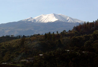
Purace
Colombia
2.3095°N, 76.3948°W; summit elev. 4650 m
All times are local (unless otherwise noted)
Observatorio Vulcanológico y Sismológico de Popayán, Servicio Geologico Colombiano (SGC) reported increased unrest at Puracé on 5 January. A sudden increase in carbon dioxide emissions was detected during the morning and decreased through the day; increased gas emissions were visible in webcam images during the afternoon. Seismicity increased at 1450 and continued at high levels at least through 1715, the time the report was issued. The earthquake signals indicated fluid movement, had low magnitudes, and were located less than 2 km below the summit. The Alert Level remained at Yellow (the second level on a four-color scale).
Geological Summary. Puracé is an active andesitic volcano with a 600-m-diameter summit crater at the NW end of the Los Coconucos Volcanic Chain. This volcanic complex includes nine composite and five monogenetic volcanoes, extending from the Puracé crater more than 6 km SE to the summit of Pan de Azúcar stratovolcano. The dacitic massif which the complex is built on extends about 13 km NW-SE and 10 km NE-SW. Frequent small to moderate explosive eruptions reported since 1816 CE have modified the morphology of the summit crater, with the largest eruptions in 1849, 1869, and 1885.