Report on Purace (Colombia) — 10 December-16 December 2025
Smithsonian Institution / US Geological Survey
Weekly Volcanic Activity Report, 10 December-16 December 2025
Managing Editor: Sally Sennert.
Please cite this report as:
Global Volcanism Program, 2025. Report on Purace (Colombia) (Sennert, S, ed.). Weekly Volcanic Activity Report, 10 December-16 December 2025. Smithsonian Institution and US Geological Survey.
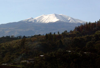
Purace
Colombia
2.3095°N, 76.3948°W; summit elev. 4650 m
All times are local (unless otherwise noted)
The Servicio Geologico Colombiano (SGC) reported continuing eruptive activity at Puracé during 9-16 December. Seismicity was characterized by pulses of tremor, long-period signals indicating fluid movement, and periods of continuous tremor. The seismicity was located at depths less than 1 km and was related to internal movement of gases as well as emissions. Earthquakes indicating rock fracturing were located within 3 km of the crater at depths of 1-3 km. Gas-and-ash emissions, 2-15 per day, were associated with some seismic signals and visible in webcam images rising 700-800 m above the summit and drifting downwind. Significant sulfur dioxide emissions detected in satellite data dispersed within 300 m NE, NW, and W of the crater. Elevated temperatures in the crater area continued to be detected and were possibly associated with the emissions of hot gases. During 10-11 December minor ashfall and a weak sulfur odor was reported in Cristales (NW), in Pululó, Anambío (7 km NW), Coconuco (12 km WNW), Crucero de la Mina (6 km N), and the former Puracé police base to the N. Ashfall was reported in Cristales as well as in Río Negro (20 km SW) during 11-12 December, in Coconuco and in Río Negro during 12-13 December, and in Cristales and Chiliglo (11 km W) during 14-15 December. The Alert Level remained at Orange (the second highest level on a four-color scale) and the public was warned to stay away from the crater.
Geological Summary. Puracé is an active andesitic volcano with a 600-m-diameter summit crater at the NW end of the Los Coconucos Volcanic Chain. This volcanic complex includes nine composite and five monogenetic volcanoes, extending from the Puracé crater more than 6 km SE to the summit of Pan de Azúcar stratovolcano. The dacitic massif which the complex is built on extends about 13 km NW-SE and 10 km NE-SW. Frequent small to moderate explosive eruptions reported since 1816 CE have modified the morphology of the summit crater, with the largest eruptions in 1849, 1869, and 1885.