The Global Volcanism Program has no activity reports available for Reporoa.
The Global Volcanism Program has no Weekly Reports available for Reporoa.
The Global Volcanism Program has no Bulletin Reports available for Reporoa.
|
|
||||||||||||||||||||||||||||
The Global Volcanism Program is not aware of any Holocene eruptions from Reporoa. If this volcano has had large eruptions (VEI >= 4) prior to 12,000 years ago, information might be found on the Reporoa page in the LaMEVE (Large Magnitude Explosive Volcanic Eruptions) database, a part of the Volcano Global Risk Identification and Analysis Project (VOGRIPA).
This compilation of synonyms and subsidiary features may not be comprehensive. Features are organized into four major categories: Cones, Craters, Domes, and Thermal Features. Synonyms of features appear indented below the primary name. In some cases additional feature type, elevation, or location details are provided.
Craters |
||||
| Feature Name | Feature Type | Elevation | Latitude | Longitude |
| Ngahewa, Lake | Crater | 411 m | 38° 19' 0.00" S | 176° 23' 0.00" E |
| Ngapouri, Lake
Opouri, Lake |
Crater | 477 m | 38° 20' 0.00" S | 176° 20' 0.00" E |
| Okaro, Lake | Crater | |||
Domes |
||||
| Feature Name | Feature Type | Elevation | Latitude | Longitude |
| Deer Hill | Dome | |||
| Kairuru | Dome | 447 m | 38° 27' 0.00" S | 176° 19' 0.00" E |
| Pukekahu | Dome | 346 m | 38° 28' 0.00" S | 176° 21' 0.00" E |
Thermal |
||||
| Feature Name | Feature Type | Elevation | Latitude | Longitude |
| Broadlands
Ohaki Ohaaki |
Thermal | 300 m | 38° 33' 0.00" S | 176° 19' 0.00" E |
| Waiotapu | Thermal | 460 m | 38° 20' 0.00" S | 176° 20' 28.00" E |
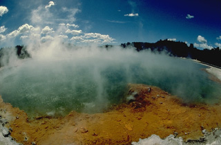 Steaming Champagne Pool is one of many thermal features of the 10-km-wide Reporoa caldera. The caldera was formed about 230,000 years ago during the eruption of the Kaingaroa ignimbrite. No eruptions have occurred since the Pleistocene in the caldera, but hydrothermal explosions took place in the Waiotapu thermal field north of the caldera at the time of the Kaharoa eruption of the Okataina volcanic centre about 800 years ago. The Broadlands (Ohaki) hydrothermal field is located south of the poorly defined caldera margin.
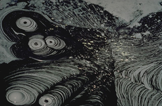 Bubbling mud pots at a thermal area of New Zealand's Reporoa caldera form geometric patterns. Mud pots form in thermal areas where the gas phase is dominant over the liquid phase and extensive hydrothermal alteration of rocks has occurred, producing fine-grained, clay-rich material.
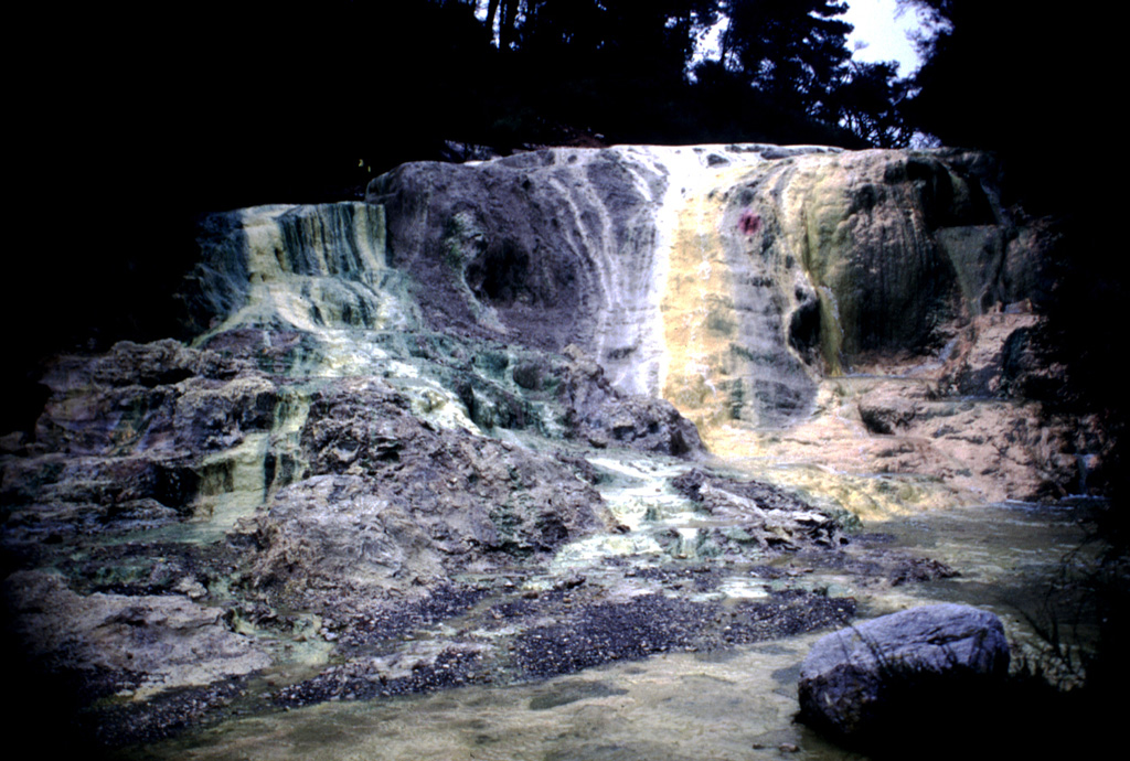
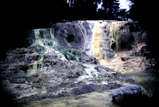 Multi-colored Bridal Veil Falls were formed from silica terraces created when mineralized water poured over from the Primrose Pool of the Wai-O-Tapu thermal area. The noted hydrothermal area lies within the 10-km-wide Reporoa caldera, which was formed during the Pleistocene in the Reporoa-Broadlands basin near the western margin of the Taupo volcanic zone. Large hydrothermal explosions took place from the Wai-O-Tapu thermal area at the time of the Kaharoa eruption of neighboring Tarawera volcano (Okataina Volcanic Centre) about 700 years ago.
The following 10 samples associated with this volcano can be found in the Smithsonian's NMNH Department of Mineral Sciences collections, and may be availble for research (contact the Rock and Ore Collections Manager). Catalog number links will open a window with more information.
| Catalog Number | Sample Description | Lava Source | Collection Date |
|---|---|---|---|
| NMNH 116418-1 | Ignimbrite | WAIOTAPU | -- |
| NMNH 116566-1 | Volcanic Rock | BROADLANDS | -- |
| NMNH 116566-2 | Volcanic Rock | BROADLANDS | -- |
| NMNH 116566-3 | Volcanic Rock | BROADLANDS | -- |
| NMNH 116566-4 | Volcanic Rock | BROADLANDS | -- |
| NMNH 116566-5 | Volcanic Rock | BROADLANDS | -- |
| NMNH 116566-6 | Volcanic Rock | BROADLANDS | -- |
| NMNH 116566-7 | Volcanic Rock | BROADLANDS | -- |
| NMNH 116566-8 | Volcanic Rock | BROADLANDS | -- |
| NMNH 116566-9 | Volcanic Rock | BROADLANDS | -- |
| Copernicus Browser | The Copernicus Browser replaced the Sentinel Hub Playground browser in 2023, to provide access to Earth observation archives from the Copernicus Data Space Ecosystem, the main distribution platform for data from the EU Copernicus missions. |
|
WOVOdat
Single Volcano View Temporal Evolution of Unrest Side by Side Volcanoes |
WOVOdat is a database of volcanic unrest; instrumentally and visually recorded changes in seismicity, ground deformation, gas emission, and other parameters from their normal baselines. It is sponsored by the World Organization of Volcano Observatories (WOVO) and presently hosted at the Earth Observatory of Singapore.
GVMID Data on Volcano Monitoring Infrastructure The Global Volcano Monitoring Infrastructure Database GVMID, is aimed at documenting and improving capabilities of volcano monitoring from the ground and space. GVMID should provide a snapshot and baseline view of the techniques and instrumentation that are in place at various volcanoes, which can be use by volcano observatories as reference to setup new monitoring system or improving networks at a specific volcano. These data will allow identification of what monitoring gaps exist, which can be then targeted by remote sensing infrastructure and future instrument deployments. |
| IRIS seismic stations/networks | Incorporated Research Institutions for Seismology (IRIS) Data Services map showing the location of seismic stations from all available networks (permanent or temporary) within a radius of 0.18° (about 20 km at mid-latitudes) from the given location of Reporoa. Users can customize a variety of filters and options in the left panel. Note that if there are no stations are known the map will default to show the entire world with a "No data matched request" error notice. |
| UNAVCO GPS/GNSS stations | Geodetic Data Services map from UNAVCO showing the location of GPS/GNSS stations from all available networks (permanent or temporary) within a radius of 20 km from the given location of Reporoa. Users can customize the data search based on station or network names, location, and time window. Requires Adobe Flash Player. |
| Large Eruptions of Reporoa | Information about large Quaternary eruptions (VEI >= 4) is cataloged in the Large Magnitude Explosive Volcanic Eruptions (LaMEVE) database of the Volcano Global Risk Identification and Analysis Project (VOGRIPA). |
| EarthChem | EarthChem develops and maintains databases, software, and services that support the preservation, discovery, access and analysis of geochemical data, and facilitate their integration with the broad array of other available earth science parameters. EarthChem is operated by a joint team of disciplinary scientists, data scientists, data managers and information technology developers who are part of the NSF-funded data facility Integrated Earth Data Applications (IEDA). IEDA is a collaborative effort of EarthChem and the Marine Geoscience Data System (MGDS). |

