The Global Volcanism Program has no activity reports available for Feni.
The Global Volcanism Program has no Weekly Reports available for Feni.
The Global Volcanism Program has no Bulletin Reports available for Feni.
|
|
||||||||||||||||||||||||||
There is data available for 0 confirmed eruptive period.
[ 0350 BCE ± 100 years ] Uncertain Eruption
| Episode 1 | Uncertain | East side of caldera | ||||||||||||||||||
|---|---|---|---|---|---|---|---|---|---|---|---|---|---|---|---|---|---|---|---|
| 0350 BCE ± 100 years - Unknown | Evidence from Isotopic: 14C (uncalibrated) | ||||||||||||||||||
| Licence at al. (1987) reported that "On the eastern side of the domes there is a very recent crater, interpreted as a maar approximately 800 m wide. This crater resulted from a phreato magmatic eruptive event which blanketed much of the central caldera, an area of approximately 9 km2, with a 5-30 m thick trachyte tuff-breccia deposit (three 14C dates age the deposit at 2,300 ± 100 years." The mapped crater is not evident among the highly irregular eroded surface visible in satellite images (as of 2025), and no other details about the samples used to date the deposit were noted. Both the age and determination of magmatic involvement are uncertain, along with a source for the deposit. | |||||||||||||||||||
|
List of 2 Events for Episode 1 at East side of caldera
|
|||||||||||||||||||
This compilation of synonyms and subsidiary features may not be comprehensive. Features are organized into four major categories: Cones, Craters, Domes, and Thermal Features. Synonyms of features appear indented below the primary name. In some cases additional feature type, elevation, or location details are provided.
Synonyms |
||||
| Anir | ||||
Cones |
||||
| Feature Name | Feature Type | Elevation | Latitude | Longitude |
| Ambitle | Stratovolcano | 448 m | 4° 3' 56.00" S | 153° 37' 12.00" E |
| Babase | Stratovolcano | 200 m | 4° 2' 0.00" S | 153° 43' 0.00" E |
Thermal |
||||
| Feature Name | Feature Type | Elevation | Latitude | Longitude |
| Kapkai | Thermal | |||
| Nanum River | Thermal | 4° 5' 0.00" S | 153° 38' 0.00" E | |
| Saddle | Thermal | |||
| Waramung Plantation | Thermal | 4° 5' 0.00" S | 153° 38' 0.00" E | |
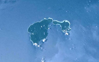 Ambitle (left center) is the larger of two adjacent islands forming the Feni Islands. The 13-km-long island is dominantly Pliocene-to-Pleistocene with a 3-km-wide central caldera. A maar on the E side of post-caldera lava domes formed about 2,300 years ago. Thermal areas are active within the caldera and just off the W coast. Babase Island, immediately to the NE of Ambitle, is a Pleistocene volcano and lava dome connected by a narrow isthmus.
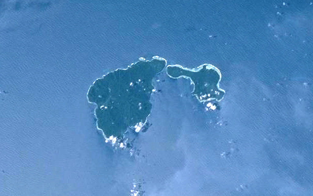
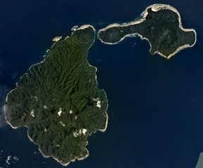 Ambitle Island is on the left and Babase Island is to the upper right in this February 2020 Planet Labs satellite image monthly mosaic (N is at the top; this image is approximately 21 km across). The 900 x 550 m Ambitle crater is near the center of the larger island and formed within a flank collapse scarp. Lava domes produced block-and-ash flow deposits and lava flows are also present.
There are no samples for Feni in the Smithsonian's NMNH Department of Mineral Sciences Rock and Ore collection.
| Copernicus Browser | The Copernicus Browser replaced the Sentinel Hub Playground browser in 2023, to provide access to Earth observation archives from the Copernicus Data Space Ecosystem, the main distribution platform for data from the EU Copernicus missions. |
|
WOVOdat
Single Volcano View Temporal Evolution of Unrest Side by Side Volcanoes |
WOVOdat is a database of volcanic unrest; instrumentally and visually recorded changes in seismicity, ground deformation, gas emission, and other parameters from their normal baselines. It is sponsored by the World Organization of Volcano Observatories (WOVO) and presently hosted at the Earth Observatory of Singapore.
GVMID Data on Volcano Monitoring Infrastructure The Global Volcano Monitoring Infrastructure Database GVMID, is aimed at documenting and improving capabilities of volcano monitoring from the ground and space. GVMID should provide a snapshot and baseline view of the techniques and instrumentation that are in place at various volcanoes, which can be use by volcano observatories as reference to setup new monitoring system or improving networks at a specific volcano. These data will allow identification of what monitoring gaps exist, which can be then targeted by remote sensing infrastructure and future instrument deployments. |
| IRIS seismic stations/networks | Incorporated Research Institutions for Seismology (IRIS) Data Services map showing the location of seismic stations from all available networks (permanent or temporary) within a radius of 0.18° (about 20 km at mid-latitudes) from the given location of Feni. Users can customize a variety of filters and options in the left panel. Note that if there are no stations are known the map will default to show the entire world with a "No data matched request" error notice. |
| UNAVCO GPS/GNSS stations | Geodetic Data Services map from UNAVCO showing the location of GPS/GNSS stations from all available networks (permanent or temporary) within a radius of 20 km from the given location of Feni. Users can customize the data search based on station or network names, location, and time window. Requires Adobe Flash Player. |
| Large Eruptions of Feni | Information about large Quaternary eruptions (VEI >= 4) is cataloged in the Large Magnitude Explosive Volcanic Eruptions (LaMEVE) database of the Volcano Global Risk Identification and Analysis Project (VOGRIPA). |
| EarthChem | EarthChem develops and maintains databases, software, and services that support the preservation, discovery, access and analysis of geochemical data, and facilitate their integration with the broad array of other available earth science parameters. EarthChem is operated by a joint team of disciplinary scientists, data scientists, data managers and information technology developers who are part of the NSF-funded data facility Integrated Earth Data Applications (IEDA). IEDA is a collaborative effort of EarthChem and the Marine Geoscience Data System (MGDS). |

