The Global Volcanism Program has no activity reports available for Singkut.
The Global Volcanism Program has no Weekly Reports available for Singkut.
The Global Volcanism Program has no Bulletin Reports available for Singkut.
|
|
||||||||||||||||||||||||||
There is data available for 1 confirmed eruptive period.
1881 Confirmed Eruption (Explosive / Effusive)
| Episode 1 | Eruption (Explosive / Effusive) | |||||||||||||||||||
|---|---|---|---|---|---|---|---|---|---|---|---|---|---|---|---|---|---|---|---|
| 1881 - Unknown | Evidence from Observations: Reported | ||||||||||||||||||
| According to Hoekstra, the volcano emitted ash clouds in 1881 (Neumann van Padang, 1983). Eruptions are mentioned in local legends. | |||||||||||||||||||
|
List of 2 Events for Episode 1
|
|||||||||||||||||||
This compilation of synonyms and subsidiary features may not be comprehensive. Features are organized into four major categories: Cones, Craters, Domes, and Thermal Features. Synonyms of features appear indented below the primary name. In some cases additional feature type, elevation, or location details are provided.
Cones |
||||
| Feature Name | Feature Type | Elevation | Latitude | Longitude |
| Pintau
Pinto |
Cone | 2181 m | 3° 14' 52.00" N | 98° 30' 5.00" E |
| Pratektekan | Cone | 1898 m | 3° 14' 15.00" N | 98° 31' 9.00" E |
| Sibayak
Sibajak |
Cone | 2054 m | 3° 14' 27.00" N | 98° 30' 11.00" E |
Craters |
||||
| Feature Name | Feature Type | Elevation | Latitude | Longitude |
| Singkut | Pleistocene caldera | 1350 m | 3° 15' 30.00" N | 98° 30' 51.00" E |
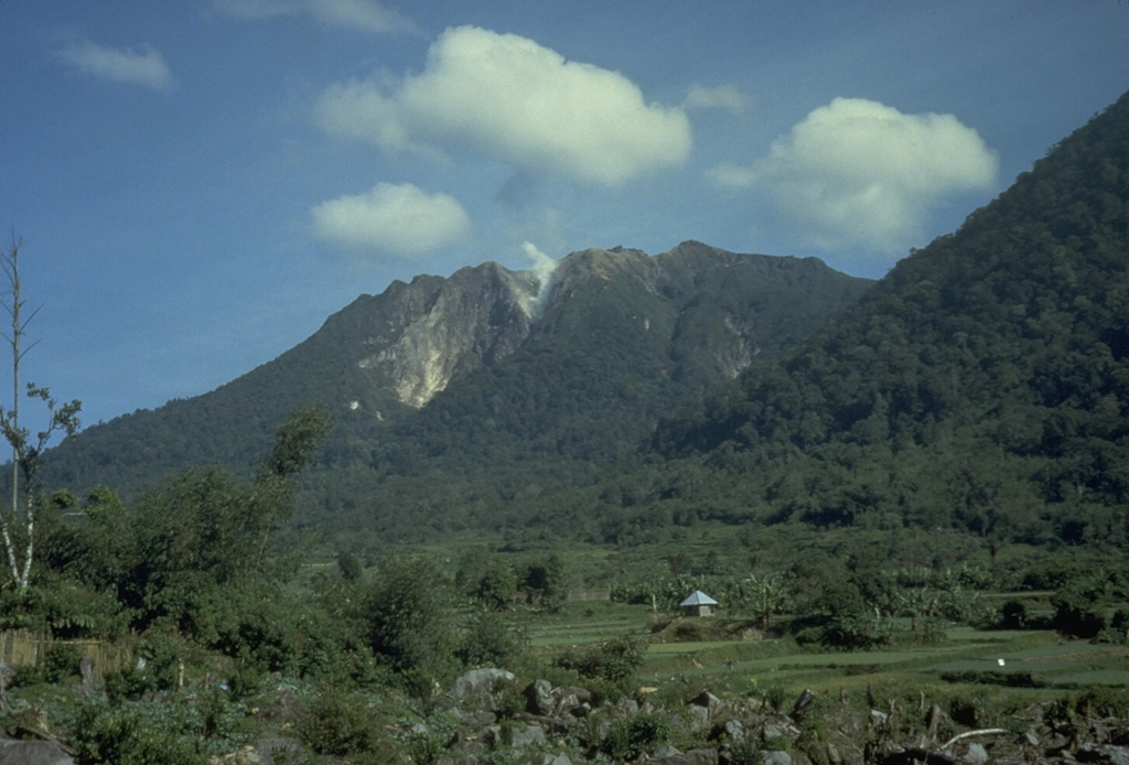
 Sibayak and Mt. Pinto are located within the Singkut caldera in NE Sumatra. The slightly higher Pinto partially overtops the 900-m-wide crater of Sibayak to the N. The summit contains a lava dome and an area of hydrothermal alteration visible in this photo. An ash eruption from Sibayak was recorded in 1881, and nearby residents have legends of eruptions.
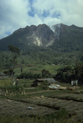 A plume rises from a thermal area near the summit of Sibayak volcano within Singkut caldera. Sibayak is seen here from a village in the flat-floored caldera S of the summit.
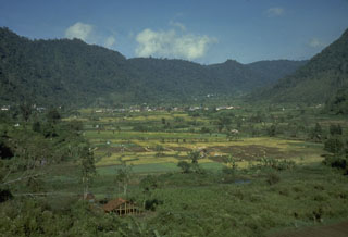 The ridge in the background of this photo is part of the wall of a caldera that contains Sibayak and Pinto volcanoes. The lower slope of Sibayak rises at the far right above the caldera floor, which is occupied by villages and agricultural land.
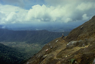 Climbers along a path near the summit of Sibayak volcano. The horizontal forested ridge in the center background, forming part of the southern caldera wall of Singkut, is viewed from an area of hydrothermally altered rock near the summit.
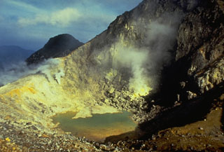 A 300-m-wide crater near the summit of Sibayak volcano contains a small turquoise-colored crater lake and areas of extensive hydrothermal alteration and sulfur mineralization. Plumes rise above active fumaroles at several locations along the far crater wall.
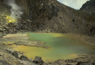 A small crater lake near the summit of Sibayak volcano shows active fumaroles and sulfur mineralization. An active fumarole is visible at the upper left. The lake is popular destination for weekend climbers from villages and towns surrounding the volcano.
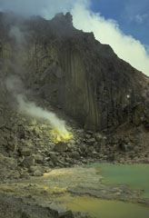 A crater containing a small turquoise-colored lake and active sulfur-coated fumaroles on the summit lava dome of Sibayak volcano. The volcano is considered to be the abode of Nini Kertah Ernala ("Grandmother of the Gleaming Sulfur"), the mountain's spirit.
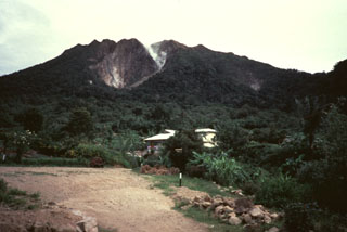 Gunung Sibayak, seen here from the S, is the southernmost of two volcanoes constructed within the Singkut caldera. Several villages occupy the flat-bottomed caldera floor. Plumes rise from fumaroles on the flank of a lava dome in the summit crater.
There are no samples for Singkut in the Smithsonian's NMNH Department of Mineral Sciences Rock and Ore collection.
| Copernicus Browser | The Copernicus Browser replaced the Sentinel Hub Playground browser in 2023, to provide access to Earth observation archives from the Copernicus Data Space Ecosystem, the main distribution platform for data from the EU Copernicus missions. |
| MIROVA | Middle InfraRed Observation of Volcanic Activity (MIROVA) is a near real time volcanic hot-spot detection system based on the analysis of MODIS (Moderate Resolution Imaging Spectroradiometer) data. In particular, MIROVA uses the Middle InfraRed Radiation (MIR), measured over target volcanoes, in order to detect, locate and measure the heat radiation sourced from volcanic activity. |
| MODVOLC Thermal Alerts | Using infrared satellite Moderate Resolution Imaging Spectroradiometer (MODIS) data, scientists at the Hawai'i Institute of Geophysics and Planetology, University of Hawai'i, developed an automated system called MODVOLC to map thermal hot-spots in near real time. For each MODIS image, the algorithm automatically scans each 1 km pixel within it to check for high-temperature hot-spots. When one is found the date, time, location, and intensity are recorded. MODIS looks at every square km of the Earth every 48 hours, once during the day and once during the night, and the presence of two MODIS sensors in space allows at least four hot-spot observations every two days. Each day updated global maps are compiled to display the locations of all hot spots detected in the previous 24 hours. There is a drop-down list with volcano names which allow users to 'zoom-in' and examine the distribution of hot-spots at a variety of spatial scales. |
|
WOVOdat
Single Volcano View Temporal Evolution of Unrest Side by Side Volcanoes |
WOVOdat is a database of volcanic unrest; instrumentally and visually recorded changes in seismicity, ground deformation, gas emission, and other parameters from their normal baselines. It is sponsored by the World Organization of Volcano Observatories (WOVO) and presently hosted at the Earth Observatory of Singapore.
GVMID Data on Volcano Monitoring Infrastructure The Global Volcano Monitoring Infrastructure Database GVMID, is aimed at documenting and improving capabilities of volcano monitoring from the ground and space. GVMID should provide a snapshot and baseline view of the techniques and instrumentation that are in place at various volcanoes, which can be use by volcano observatories as reference to setup new monitoring system or improving networks at a specific volcano. These data will allow identification of what monitoring gaps exist, which can be then targeted by remote sensing infrastructure and future instrument deployments. |
| Volcanic Hazard Maps | The IAVCEI Commission on Volcanic Hazards and Risk has a Volcanic Hazard Maps database designed to serve as a resource for hazard mappers (or other interested parties) to explore how common issues in hazard map development have been addressed at different volcanoes, in different countries, for different hazards, and for different intended audiences. In addition to the comprehensive, searchable Volcanic Hazard Maps Database, this website contains information about diversity of volcanic hazard maps, illustrated using examples from the database. This site is for educational purposes related to volcanic hazard maps. Hazard maps found on this website should not be used for emergency purposes. For the most recent, official hazard map for a particular volcano, please seek out the proper institutional authorities on the matter. |
| IRIS seismic stations/networks | Incorporated Research Institutions for Seismology (IRIS) Data Services map showing the location of seismic stations from all available networks (permanent or temporary) within a radius of 0.18° (about 20 km at mid-latitudes) from the given location of Singkut. Users can customize a variety of filters and options in the left panel. Note that if there are no stations are known the map will default to show the entire world with a "No data matched request" error notice. |
| UNAVCO GPS/GNSS stations | Geodetic Data Services map from UNAVCO showing the location of GPS/GNSS stations from all available networks (permanent or temporary) within a radius of 20 km from the given location of Singkut. Users can customize the data search based on station or network names, location, and time window. Requires Adobe Flash Player. |
| DECADE Data | The DECADE portal, still in the developmental stage, serves as an example of the proposed interoperability between The Smithsonian Institution's Global Volcanism Program, the Mapping Gas Emissions (MaGa) Database, and the EarthChem Geochemical Portal. The Deep Earth Carbon Degassing (DECADE) initiative seeks to use new and established technologies to determine accurate global fluxes of volcanic CO2 to the atmosphere, but installing CO2 monitoring networks on 20 of the world's 150 most actively degassing volcanoes. The group uses related laboratory-based studies (direct gas sampling and analysis, melt inclusions) to provide new data for direct degassing of deep earth carbon to the atmosphere. |
| Large Eruptions of Singkut | Information about large Quaternary eruptions (VEI >= 4) is cataloged in the Large Magnitude Explosive Volcanic Eruptions (LaMEVE) database of the Volcano Global Risk Identification and Analysis Project (VOGRIPA). |
| EarthChem | EarthChem develops and maintains databases, software, and services that support the preservation, discovery, access and analysis of geochemical data, and facilitate their integration with the broad array of other available earth science parameters. EarthChem is operated by a joint team of disciplinary scientists, data scientists, data managers and information technology developers who are part of the NSF-funded data facility Integrated Earth Data Applications (IEDA). IEDA is a collaborative effort of EarthChem and the Marine Geoscience Data System (MGDS). |

