CVGHM reported that seismicity at Sundoro continued to increase into January after the Alert Level was raised from 1 to 2 (on a scale of 1-4) on 5 December 2011. After the first week of January through 27 March the number of daily earthquakes significantly decreased. The Alert Level was lowered to 1 on 30 March.
Source: Pusat Vulkanologi dan Mitigasi Bencana Geologi (PVMBG, also known as CVGHM)
Fumarolic and seismic activity in late 2011 results in brief rise in alert level
The last eruption reported for Sundoro volcano occurred 29 October 1971; however, that did not stimulate a resulting Bulletin report and this is our first on this volcano. According to Indonesian Center of Volcanology and Geological Hazard Mitigation (CVGHM), visual observations of Sundoro volcano during October - 4 December 2011 indicated 'smoke' from fumaroles around the summit crater. Average fumarole temperatures of 75°C on 26 October and 95°C on 2 November 2011 were measured. On November 2, the height of the 'smoke' had passed the rim of the volcano's crater. Seismic activity, especially volcanic earthquakes (deep volcanic tremors-VA, and shallow volcanic tremors-VB), began to increase in November 2011. On 5 December 2011, the Alert status (on a scale of I to IV) for Sundoro was raised from Normal (Level I) to Alert (Level II). Seismicity remained elevated through the first week of January 2012.
Throughout the rest of January, February, and through March 2012, a significant decrease of volcanic earthquakes (both VA and VB) was noted. Thus, the Alert status was lowered to Level I on 30 March 2012.
The area of Mt. Sundoro (also known as Sindoro; close to Mt. Sumbing) on Java (see figure 1 in BGVN 33:11), was the subject of a study of people's perceptions and reactions to volcanic hazards (Lavigne and others, 2008).
Reference: Lavigne, F., De Coster, B., Juvin, N., Flohic, F., Gaillard, J-C., Texier, P., Morin, J., and Sartohadi, J., 2008, People's behaviour in the face of volcanic hazards: Perspectives from Javanese communities, Indonesia, Journal of Volcanology and Geothermal Research, v.172, issue 3-4, p. 273-287.
Information Contacts: Center of Volcanology and Geological Hazard Mitigation (CVGHM) (URL: http://www.vsi.esdm.go.id/).
CVGHM reported that seismicity at Sundoro continued to increase into January after the Alert Level was raised from 1 to 2 (on a scale of 1-4) on 5 December 2011. After the first week of January through 27 March the number of daily earthquakes significantly decreased. The Alert Level was lowered to 1 on 30 March.
Source: Pusat Vulkanologi dan Mitigasi Bencana Geologi (PVMBG, also known as CVGHM)
CVGHM reported increased seismic activity at Sundoro during October -4 December. On 26 November and 2 December smoke was reported from many fumaroles around the summit crater. Based on visual and seismic data, CVGHM raised the Alert Level from 1 to 2 (on a scale of 1-4) on 5 December.
Source: Pusat Vulkanologi dan Mitigasi Bencana Geologi (PVMBG, also known as CVGHM)
Reports are organized chronologically and indexed below by Month/Year (Publication Volume:Number), and include a one-line summary. Click on the index link or scroll down to read the reports.
Fumarolic and seismic activity in late 2011 results in brief rise in alert level
The last eruption reported for Sundoro volcano occurred 29 October 1971; however, that did not stimulate a resulting Bulletin report and this is our first on this volcano. According to Indonesian Center of Volcanology and Geological Hazard Mitigation (CVGHM), visual observations of Sundoro volcano during October - 4 December 2011 indicated 'smoke' from fumaroles around the summit crater. Average fumarole temperatures of 75°C on 26 October and 95°C on 2 November 2011 were measured. On November 2, the height of the 'smoke' had passed the rim of the volcano's crater. Seismic activity, especially volcanic earthquakes (deep volcanic tremors-VA, and shallow volcanic tremors-VB), began to increase in November 2011. On 5 December 2011, the Alert status (on a scale of I to IV) for Sundoro was raised from Normal (Level I) to Alert (Level II). Seismicity remained elevated through the first week of January 2012.
Throughout the rest of January, February, and through March 2012, a significant decrease of volcanic earthquakes (both VA and VB) was noted. Thus, the Alert status was lowered to Level I on 30 March 2012.
The area of Mt. Sundoro (also known as Sindoro; close to Mt. Sumbing) on Java (see figure 1 in BGVN 33:11), was the subject of a study of people's perceptions and reactions to volcanic hazards (Lavigne and others, 2008).
Reference: Lavigne, F., De Coster, B., Juvin, N., Flohic, F., Gaillard, J-C., Texier, P., Morin, J., and Sartohadi, J., 2008, People's behaviour in the face of volcanic hazards: Perspectives from Javanese communities, Indonesia, Journal of Volcanology and Geothermal Research, v.172, issue 3-4, p. 273-287.
Information Contacts: Center of Volcanology and Geological Hazard Mitigation (CVGHM) (URL: http://www.vsi.esdm.go.id/).
|
|
||||||||||||||||||||||||||
There is data available for 11 confirmed eruptive periods.
1971 Oct 29 - 1971 Nov 9 Confirmed Eruption (Explosive / Effusive) VEI: 2
| Episode 1 | Eruption (Explosive / Effusive) | ||||||||||||||||||||||||
|---|---|---|---|---|---|---|---|---|---|---|---|---|---|---|---|---|---|---|---|---|---|---|---|---|
| 1971 Oct 29 - 1971 Nov 9 | Evidence from Observations: Reported | |||||||||||||||||||||||
|
List of 3 Events for Episode 1
|
||||||||||||||||||||||||
1906 Sep 22 - 1906 Dec 20 Confirmed Eruption (Explosive / Effusive) VEI: 2
| Episode 1 | Eruption (Explosive / Effusive) | Summit crater K5 | |||||||||||||||||||||||
|---|---|---|---|---|---|---|---|---|---|---|---|---|---|---|---|---|---|---|---|---|---|---|---|---|
| 1906 Sep 22 - 1906 Dec 20 | Evidence from Observations: Reported | |||||||||||||||||||||||
|
List of 3 Events for Episode 1 at Summit crater K5
|
||||||||||||||||||||||||
1903 Oct 17 - 1903 Oct 21 (?) Confirmed Eruption (Explosive / Effusive) VEI: 2
| Episode 1 | Eruption (Explosive / Effusive) | Upper NE and SW flanks (2850-2980 m) | ||||||||||||||||||||||||||||
|---|---|---|---|---|---|---|---|---|---|---|---|---|---|---|---|---|---|---|---|---|---|---|---|---|---|---|---|---|---|
| 1903 Oct 17 - 1903 Oct 21 (?) | Evidence from Observations: Reported | ||||||||||||||||||||||||||||
|
List of 4 Events for Episode 1 at Upper NE and SW flanks (2850-2980 m)
|
|||||||||||||||||||||||||||||
1902 May 1 - 1902 May 25 Confirmed Eruption (Explosive / Effusive) VEI: 1
| Episode 1 | Eruption (Explosive / Effusive) | ||||||||||||||||||||||||
|---|---|---|---|---|---|---|---|---|---|---|---|---|---|---|---|---|---|---|---|---|---|---|---|---|
| 1902 May 1 - 1902 May 25 | Evidence from Observations: Reported | |||||||||||||||||||||||
|
List of 3 Events for Episode 1
|
||||||||||||||||||||||||
1887 Nov 13 - 1887 Nov 14 Confirmed Eruption (Explosive / Effusive) VEI: 2
| Episode 1 | Eruption (Explosive / Effusive) | |||||||||||||||||||
|---|---|---|---|---|---|---|---|---|---|---|---|---|---|---|---|---|---|---|---|
| 1887 Nov 13 - 1887 Nov 14 | Evidence from Observations: Reported | ||||||||||||||||||
|
List of 2 Events for Episode 1
|
|||||||||||||||||||
1883 Aug (?) Confirmed Eruption (Explosive / Effusive) VEI: 2
| Episode 1 | Eruption (Explosive / Effusive) | |||||||||||||||||||
|---|---|---|---|---|---|---|---|---|---|---|---|---|---|---|---|---|---|---|---|
| 1883 Aug (?) - Unknown | Evidence from Observations: Reported | ||||||||||||||||||
|
List of 2 Events for Episode 1
|
|||||||||||||||||||
1882 Apr 1 - 1882 Apr 7 Confirmed Eruption (Explosive / Effusive) VEI: 2
| Episode 1 | Eruption (Explosive / Effusive) | Summit, NW and NE flanks | |||||||||||||||||||||||||||||||||
|---|---|---|---|---|---|---|---|---|---|---|---|---|---|---|---|---|---|---|---|---|---|---|---|---|---|---|---|---|---|---|---|---|---|---|
| 1882 Apr 1 - 1882 Apr 7 | Evidence from Observations: Reported | |||||||||||||||||||||||||||||||||
|
List of 5 Events for Episode 1 at Summit, NW and NE flanks
|
||||||||||||||||||||||||||||||||||
1818 Confirmed Eruption (Explosive / Effusive) VEI: 2
| Episode 1 | Eruption (Explosive / Effusive) | ||||||||||||||||||||||||
|---|---|---|---|---|---|---|---|---|---|---|---|---|---|---|---|---|---|---|---|---|---|---|---|---|
| 1818 - Unknown | Evidence from Observations: Reported | |||||||||||||||||||||||
|
List of 3 Events for Episode 1
|
||||||||||||||||||||||||
1806 (?) Confirmed Eruption (Explosive / Effusive) VEI: 2
| Episode 1 | Eruption (Explosive / Effusive) | |||||||||||||||||||
|---|---|---|---|---|---|---|---|---|---|---|---|---|---|---|---|---|---|---|---|
| 1806 (?) - Unknown | Evidence from Observations: Reported | ||||||||||||||||||
|
List of 2 Events for Episode 1
|
|||||||||||||||||||
0470 (?) Confirmed Eruption (Explosive / Effusive)
| Episode 1 | Eruption (Explosive / Effusive) | |||||||||||||||||||||||||||||
|---|---|---|---|---|---|---|---|---|---|---|---|---|---|---|---|---|---|---|---|---|---|---|---|---|---|---|---|---|---|
| 0470 (?) - Unknown | Evidence from Isotopic: 14C (uncalibrated) | ||||||||||||||||||||||||||||
|
List of 4 Events for Episode 1
|
|||||||||||||||||||||||||||||
0230 (?) Confirmed Eruption (Explosive / Effusive)
| Episode 1 | Eruption (Explosive / Effusive) | |||||||||||||||||||||||||||||
|---|---|---|---|---|---|---|---|---|---|---|---|---|---|---|---|---|---|---|---|---|---|---|---|---|---|---|---|---|---|
| 0230 (?) - Unknown | Evidence from Isotopic: 14C (uncalibrated) | ||||||||||||||||||||||||||||
|
List of 4 Events for Episode 1
|
|||||||||||||||||||||||||||||
This compilation of synonyms and subsidiary features may not be comprehensive. Features are organized into four major categories: Cones, Craters, Domes, and Thermal Features. Synonyms of features appear indented below the primary name. In some cases additional feature type, elevation, or location details are provided.
Synonyms |
||||
| Soendoro | Sindoro | Sendoro | ||||
Cones |
||||
| Feature Name | Feature Type | Elevation | Latitude | Longitude |
| Arum, Gunung | Cone - Crater | 2129 m | ||
| Buntuk Gede, Gunung | Vent | 1220 m | ||
| Kekep, Gunung | Cone - Crater | 1746 m | ||
| Kembang, Gunung | Cone - Crater | 2318 m | 7° 18' 51.00" S | 109° 58' 40.00" E |
| Pagerluhir, Gunung | Vent | 1317 m | ||
| Watu, Gunung | Cone - Crater | 1657 m | ||
Craters |
||||
| Feature Name | Feature Type | Elevation | Latitude | Longitude |
| Segoro Banjaran
Segoro Bandjaran |
Crater | |||
| Segoro Wedi | Crater | |||
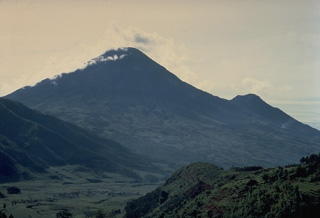 The symmetrical stratovolcano Sundoro, seen here from the NW with its flank vent of Gunung Kembang on the right, is one of two prominent stratovolcanoes SE of the Dieng volcanic complex in central Java. Explosive eruptions have occurred in historical time from both summit and flank vents.
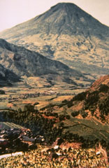 Sundoro volcano, seen here from Wadas Putih village to its NW, is SE of the Dieng volcanic complex. Explosive eruptions have occurred from both summit and flank vents at during historical time, most recently in 1971.
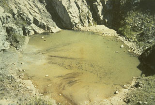 A shallow lake is seen here on the floor of the K1 crater at the summit of Sundoro volcano in 1973. The 150-m-wide, 75-m-deep crater is seen here from the rim of the K2 crater immediately to the south.
 Farmers cultivate land on the eastern flank of Gunung Sundoro in Java. The stratovolcano immediately NW of Sumbing volcano towers 2,500 m above its base. A small lava dome occupies the summit crater, which has fed lava flows in all directions. Historical eruptions typically have consisted of mild-to-moderate phreatic explosions, mostly from the summit crater, although flank vents were also active in 1882 and 1903.
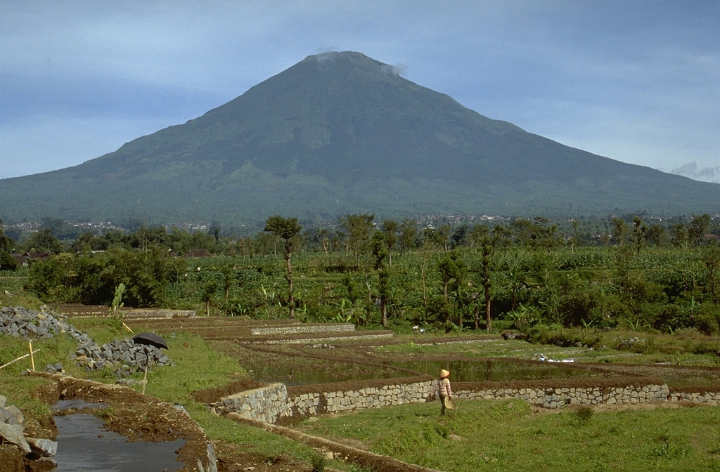
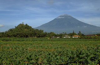 Gunung Sundoro is located immediately NE of Sumbing volcano. The hill in the foreground is part of a large deposit resulting from a prehistoric debris avalanche that traveled around 20 km prior to formation of the present-day volcano. Explosive eruptions have occurred from both summit and flank vents in historical time.
 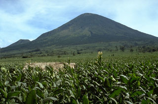 The SE flank of Gunung Sundoro rises above fields to the west. Sundoro has erupted in historical time from both summit and flank vents and the cone at the lower left is Gunung Kembang.
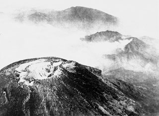 An aerial view looking towards the NW across the summit crater complex of Sundoro volcano. The forested peak at the top center is Gunung Prahu, the largest cone of the Dieng volcanic complex.
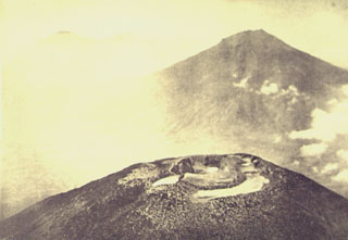 An aerial view from the NW looks across the summit crater complex of Gunung Sundoro volcano towards Gunung Sumbing. These roughly 3,000-m-high volcanoes form prominent landmarks between the Dieng volcanic complex and the city of Yogyakarta. Both volcanoes have erupted in historical time.
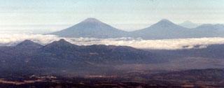 The two small peaks to the left are part of the Telomoyo volcanic complex, which was constructed along a NNW-SSE-trending line of volcanoes extending from Ungaran in the N to Merapi in the S. Telomoyo filled much of the southern side of a depression formed by collapse of the Pleistocene Soropati volcano and grew to a height of 600 m above its rim. The two large peaks in the background are Sumbing (L) and Sundoro (R), with Slamet volcano on the far-right horizon.
There are no samples for Sundoro in the Smithsonian's NMNH Department of Mineral Sciences Rock and Ore collection.
| Copernicus Browser | The Copernicus Browser replaced the Sentinel Hub Playground browser in 2023, to provide access to Earth observation archives from the Copernicus Data Space Ecosystem, the main distribution platform for data from the EU Copernicus missions. |
| MIROVA | Middle InfraRed Observation of Volcanic Activity (MIROVA) is a near real time volcanic hot-spot detection system based on the analysis of MODIS (Moderate Resolution Imaging Spectroradiometer) data. In particular, MIROVA uses the Middle InfraRed Radiation (MIR), measured over target volcanoes, in order to detect, locate and measure the heat radiation sourced from volcanic activity. |
| MODVOLC Thermal Alerts | Using infrared satellite Moderate Resolution Imaging Spectroradiometer (MODIS) data, scientists at the Hawai'i Institute of Geophysics and Planetology, University of Hawai'i, developed an automated system called MODVOLC to map thermal hot-spots in near real time. For each MODIS image, the algorithm automatically scans each 1 km pixel within it to check for high-temperature hot-spots. When one is found the date, time, location, and intensity are recorded. MODIS looks at every square km of the Earth every 48 hours, once during the day and once during the night, and the presence of two MODIS sensors in space allows at least four hot-spot observations every two days. Each day updated global maps are compiled to display the locations of all hot spots detected in the previous 24 hours. There is a drop-down list with volcano names which allow users to 'zoom-in' and examine the distribution of hot-spots at a variety of spatial scales. |
|
WOVOdat
Single Volcano View Temporal Evolution of Unrest Side by Side Volcanoes |
WOVOdat is a database of volcanic unrest; instrumentally and visually recorded changes in seismicity, ground deformation, gas emission, and other parameters from their normal baselines. It is sponsored by the World Organization of Volcano Observatories (WOVO) and presently hosted at the Earth Observatory of Singapore.
GVMID Data on Volcano Monitoring Infrastructure The Global Volcano Monitoring Infrastructure Database GVMID, is aimed at documenting and improving capabilities of volcano monitoring from the ground and space. GVMID should provide a snapshot and baseline view of the techniques and instrumentation that are in place at various volcanoes, which can be use by volcano observatories as reference to setup new monitoring system or improving networks at a specific volcano. These data will allow identification of what monitoring gaps exist, which can be then targeted by remote sensing infrastructure and future instrument deployments. |
| Volcanic Hazard Maps | The IAVCEI Commission on Volcanic Hazards and Risk has a Volcanic Hazard Maps database designed to serve as a resource for hazard mappers (or other interested parties) to explore how common issues in hazard map development have been addressed at different volcanoes, in different countries, for different hazards, and for different intended audiences. In addition to the comprehensive, searchable Volcanic Hazard Maps Database, this website contains information about diversity of volcanic hazard maps, illustrated using examples from the database. This site is for educational purposes related to volcanic hazard maps. Hazard maps found on this website should not be used for emergency purposes. For the most recent, official hazard map for a particular volcano, please seek out the proper institutional authorities on the matter. |
| IRIS seismic stations/networks | Incorporated Research Institutions for Seismology (IRIS) Data Services map showing the location of seismic stations from all available networks (permanent or temporary) within a radius of 0.18° (about 20 km at mid-latitudes) from the given location of Sundoro. Users can customize a variety of filters and options in the left panel. Note that if there are no stations are known the map will default to show the entire world with a "No data matched request" error notice. |
| UNAVCO GPS/GNSS stations | Geodetic Data Services map from UNAVCO showing the location of GPS/GNSS stations from all available networks (permanent or temporary) within a radius of 20 km from the given location of Sundoro. Users can customize the data search based on station or network names, location, and time window. Requires Adobe Flash Player. |
| DECADE Data | The DECADE portal, still in the developmental stage, serves as an example of the proposed interoperability between The Smithsonian Institution's Global Volcanism Program, the Mapping Gas Emissions (MaGa) Database, and the EarthChem Geochemical Portal. The Deep Earth Carbon Degassing (DECADE) initiative seeks to use new and established technologies to determine accurate global fluxes of volcanic CO2 to the atmosphere, but installing CO2 monitoring networks on 20 of the world's 150 most actively degassing volcanoes. The group uses related laboratory-based studies (direct gas sampling and analysis, melt inclusions) to provide new data for direct degassing of deep earth carbon to the atmosphere. |
| Large Eruptions of Sundoro | Information about large Quaternary eruptions (VEI >= 4) is cataloged in the Large Magnitude Explosive Volcanic Eruptions (LaMEVE) database of the Volcano Global Risk Identification and Analysis Project (VOGRIPA). |
| EarthChem | EarthChem develops and maintains databases, software, and services that support the preservation, discovery, access and analysis of geochemical data, and facilitate their integration with the broad array of other available earth science parameters. EarthChem is operated by a joint team of disciplinary scientists, data scientists, data managers and information technology developers who are part of the NSF-funded data facility Integrated Earth Data Applications (IEDA). IEDA is a collaborative effort of EarthChem and the Marine Geoscience Data System (MGDS). |

