
Three bursts of seismicity near Mikura Seamount
A swarm of earthquakes began at 0624 on 5 October 1990, in the sea ~20 km SW of Mikura-jima Island (figure 3). A second burst occurred 13 October, following a gradual decline from the 5th, and a third burst occurred on 21 October (figure 4). A total of about 30 shocks were felt by residents on Mikura-jima and nine were felt on Miyake-jima Island (at Miyake-jima Weather Station), ~40 km NNE of the epicentral area. The largest event was M 4.3 and occurred on 27 October. Depths of most of the located events ranged from 20 to 30 km, although depth control was poor.
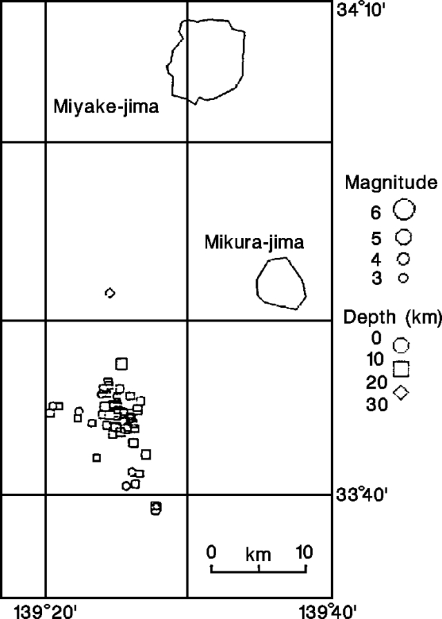 |
Figure 3. Epicentral distribution of earthquakes (M >= 3.0) off Mikura-jima, October 1990. Courtesy of JMA. |
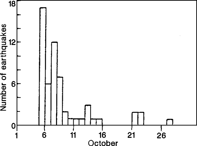 |
Figure 4. Daily number of located earthquakes off Mikura-jima, October 1990. Courtesy of JMA. |
The swarm occurred in the vicinity of Mikura Seamount, a cone-shaped feature with a summit ~300 m below sea level and 1,400 m above the surrounding sea floor. No surface phenomena were reported in the area in October, nor have any been reported in historical time. The last swarm near this site took place in December 1982, and was more vigorous, including one M 6.4 event.
Information Contacts: JMA.
The Global Volcanism Program has no Weekly Reports available for Mikura Seamount.
Reports are organized chronologically and indexed below by Month/Year (Publication Volume:Number), and include a one-line summary. Click on the index link or scroll down to read the reports.
Earthquake sequence not volcanic
Beginning 27 December there have been many recorded earthquakes with epicenters in the ocean about 40 km S of Miyake-jima Island (~200 km S of Tokyo; figures 1 and 2). The first felt shock occurred at 1533. At 1537 on 28 December the largest, magnitude [6.4] on the JMA scale, originated at the N edge of the epicentral area. It was followed by gradually decreasing aftershock activity. Earthquake swarms or main shock-aftershock events in the sea around Miyake-jima occurred in July and September 1980, and . . . March 1981. The USGS/NEIS recorded four shocks of magnitude 5 or greater (table 1).
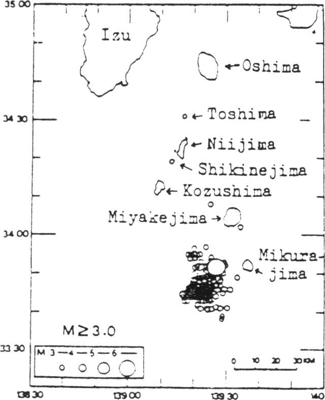 |
Figure 1. Epicenters of earthquakes larger than magnitude 3, 27-31 December 1982. The epicentral area is 40 km S of Miyake-jima Island. The largest open circle is the main shock that occurred 28 December at 1537, 30 km S of Miyake-jima. Focal depths ranged from 0-20 km. The January 1983 earthquakes were located in the same area. Courtesy of JMA. |
 |
Figure 2. Hourly and daily (inset) number of earthquakes in the Izu Islands recorded at Miyake-jima Weather Station, 27 December 1982-4 January 1983. Courtesy of JMA. |
Table 1. Earthquakes of Ms >= 5 on 28 December 1982 in the Izu Islands, Japan. Courtesy of the USGS.
| Time | Magnitude | Latitude | Longitude | Focal Depth |
| 1024 | 5.0 | 33.74°N | 139.46°E | shallow |
| 1053 | 5.5 | 33.70°N | 139.44°E | shallow |
| 1112 | 5.1 | 33.70°N | 139.52°E | shallow |
| 1537 | 6.1 | 33.77°N | 139.51°E | 20 km |
Personnel from the Miyake-jima Weather Station visited the summit area (Oyama) on 29 December, but observed no unusual phenomena. The events were interpreted as having been too far from Miyake-jima to be precursors of volcanic activity. A group of shallow earthquakes occurred close to Miyake-jima a few months before the last eruption in 1962.
Information Contacts: JMA, Tokyo; USGS/NEIS, Denver CO, USA
Three bursts of seismicity near Mikura Seamount
A swarm of earthquakes began at 0624 on 5 October 1990, in the sea ~20 km SW of Mikura-jima Island (figure 3). A second burst occurred 13 October, following a gradual decline from the 5th, and a third burst occurred on 21 October (figure 4). A total of about 30 shocks were felt by residents on Mikura-jima and nine were felt on Miyake-jima Island (at Miyake-jima Weather Station), ~40 km NNE of the epicentral area. The largest event was M 4.3 and occurred on 27 October. Depths of most of the located events ranged from 20 to 30 km, although depth control was poor.
|
Figure 3. Epicentral distribution of earthquakes (M >= 3.0) off Mikura-jima, October 1990. Courtesy of JMA. |
|
Figure 4. Daily number of located earthquakes off Mikura-jima, October 1990. Courtesy of JMA. |
The swarm occurred in the vicinity of Mikura Seamount, a cone-shaped feature with a summit ~300 m below sea level and 1,400 m above the surrounding sea floor. No surface phenomena were reported in the area in October, nor have any been reported in historical time. The last swarm near this site took place in December 1982, and was more vigorous, including one M 6.4 event.
Information Contacts: JMA.
|
|
||||||||||||||||||
The Global Volcanism Program is not aware of any Holocene eruptions from Mikura Seamount. If this volcano has had large eruptions (VEI >= 4) prior to 12,000 years ago, information might be found on the Mikura Seamount page in the LaMEVE (Large Magnitude Explosive Volcanic Eruptions) database, a part of the Volcano Global Risk Identification and Analysis Project (VOGRIPA).
The Global Volcanism Program has no synonyms or subfeatures listed for Mikura Seamount.
The Global Volcanism Program has no photographs available for Mikura Seamount.
There are no samples for Mikura Seamount in the Smithsonian's NMNH Department of Mineral Sciences Rock and Ore collection.
| Copernicus Browser | The Copernicus Browser replaced the Sentinel Hub Playground browser in 2023, to provide access to Earth observation archives from the Copernicus Data Space Ecosystem, the main distribution platform for data from the EU Copernicus missions. |
|
WOVOdat
Single Volcano View Temporal Evolution of Unrest Side by Side Volcanoes |
WOVOdat is a database of volcanic unrest; instrumentally and visually recorded changes in seismicity, ground deformation, gas emission, and other parameters from their normal baselines. It is sponsored by the World Organization of Volcano Observatories (WOVO) and presently hosted at the Earth Observatory of Singapore.
GVMID Data on Volcano Monitoring Infrastructure The Global Volcano Monitoring Infrastructure Database GVMID, is aimed at documenting and improving capabilities of volcano monitoring from the ground and space. GVMID should provide a snapshot and baseline view of the techniques and instrumentation that are in place at various volcanoes, which can be use by volcano observatories as reference to setup new monitoring system or improving networks at a specific volcano. These data will allow identification of what monitoring gaps exist, which can be then targeted by remote sensing infrastructure and future instrument deployments. |
| IRIS seismic stations/networks | Incorporated Research Institutions for Seismology (IRIS) Data Services map showing the location of seismic stations from all available networks (permanent or temporary) within a radius of 0.18° (about 20 km at mid-latitudes) from the given location of Mikura Seamount. Users can customize a variety of filters and options in the left panel. Note that if there are no stations are known the map will default to show the entire world with a "No data matched request" error notice. |
| UNAVCO GPS/GNSS stations | Geodetic Data Services map from UNAVCO showing the location of GPS/GNSS stations from all available networks (permanent or temporary) within a radius of 20 km from the given location of Mikura Seamount. Users can customize the data search based on station or network names, location, and time window. Requires Adobe Flash Player. |
| EarthChem | EarthChem develops and maintains databases, software, and services that support the preservation, discovery, access and analysis of geochemical data, and facilitate their integration with the broad array of other available earth science parameters. EarthChem is operated by a joint team of disciplinary scientists, data scientists, data managers and information technology developers who are part of the NSF-funded data facility Integrated Earth Data Applications (IEDA). IEDA is a collaborative effort of EarthChem and the Marine Geoscience Data System (MGDS). |

