
The Global Volcanism Program has no activity reports available for Kuttara.
The Global Volcanism Program has no Weekly Reports available for Kuttara.
The Global Volcanism Program has no Bulletin Reports available for Kuttara.
|
|
||||||||||||||||||||||||||
There is data available for 3 confirmed eruptive periods.
1820 ± 100 years Confirmed Eruption (Explosive / Effusive) VEI: 1
| Episode 1 | Eruption (Explosive / Effusive) | West flank (Jigoku-dani) | ||||||||||||||||||
|---|---|---|---|---|---|---|---|---|---|---|---|---|---|---|---|---|---|---|---|
| 1820 ± 100 years - Unknown | Evidence from Correlation: Tephrochronology | ||||||||||||||||||
|
List of 2 Events for Episode 1 at West flank (Jigoku-dani)
|
|||||||||||||||||||
0200 ± 75 years Confirmed Eruption (Explosive / Effusive)
| Episode 1 | Eruption (Explosive / Effusive) | |||||||||||||||||||
|---|---|---|---|---|---|---|---|---|---|---|---|---|---|---|---|---|---|---|---|
| 0200 ± 75 years - Unknown | Evidence from Isotopic: 14C (calibrated) | ||||||||||||||||||
|
List of 2 Events for Episode 1
|
|||||||||||||||||||
8050 BCE (?) Confirmed Eruption (Explosive / Effusive)
| Episode 1 | Eruption (Explosive / Effusive) | Hiyori-yama lava dome | |||||||||||||
|---|---|---|---|---|---|---|---|---|---|---|---|---|---|---|
| 8050 BCE (?) - Unknown | Evidence from Correlation: Tephrochronology | |||||||||||||
|
List of 1 Events for Episode 1 at Hiyori-yama lava dome
|
||||||||||||||
This compilation of synonyms and subsidiary features may not be comprehensive. Features are organized into four major categories: Cones, Craters, Domes, and Thermal Features. Synonyms of features appear indented below the primary name. In some cases additional feature type, elevation, or location details are provided.
Cones |
||||
| Feature Name | Feature Type | Elevation | Latitude | Longitude |
| Jigoku-dani | Pyroclastic cone | |||
| Shihorei | Pyroclastic cone | |||
| Takeura | Stratovolcano | |||
Craters |
||||
| Feature Name | Feature Type | Elevation | Latitude | Longitude |
| Hiroyiyama-Oyunuma-Urajigoku | Fissure vent | |||
| Kuttara | Caldera | |||
| Kuttara | Caldera | |||
| Oyunuma
O-Yunuma |
Crater | |||
| Tachibana | Crater | |||
| Urajigoku | Crater | |||
Domes |
||||
| Feature Name | Feature Type | Elevation | Latitude | Longitude |
| Hiyoriyama
Hiyori-yama |
Dome | |||
Thermal |
||||
| Feature Name | Feature Type | Elevation | Latitude | Longitude |
| Noboribetsu
Noboribetu |
Thermal | |||
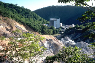 Steam rises from the Kuttara volcano Jigokudani thermal area, which contains active fumaroles, hot springs, hot pools, and mud pots. These high-rise hotels have been constructed on the western flank.
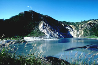 Hiyoriyama lava dome (left) was extruded during late stages of the eruption that produced the Oyunuma crater in the foreground. The dome is mantled by a thin layer of older sediments and breccias that were baked during uplift of the dome. The crater is 300-400 m wide and filled with hot water.
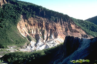 This view shows large areas of hydrothermally altered ground at the Jigokudani ("Valley of Hell") thermal area of Kuttara volcano. Jigokudani is a 300-500 m crater that formed on the W flank of Kuttara.
 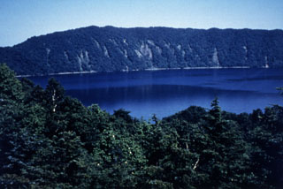 Lake Kuttara fills the 3-km-wide Kuttara caldera, which formed during major late-Pleistocene explosive eruptions. Pumice-rich pyroclastic flow deposits from this eruption cover a wide area around the volcano. Post-caldera volcanism constructed a group of explosion craters and a lava dome on the W flank. A phreatic explosion at one of the W-flank craters postdates the 1663 CE eruption of nearby Usu volcano.
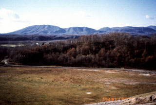 Kuttara volcano, seen here from Shiraoi town, is a low cone that has a 3-km-wide caldera at its summit. The caldera formed during the late Pleistocene, but minor explosions occurred from a crater in a western-flank thermal area as recently as about 200 years ago.
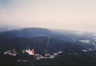 Kuttara volcano consists of a 3-km-wide, lake-filled caldera seen here from the W, near the Pacific coast of Hokkaido. Post-caldera eruptions have produced a series of explosion craters on the west flank. Thermal activity associated with these craters has produced large areas of hydrothermally altered ground seen at the bottom of the photo. The resort town of Noboribetsu Spa is visible at the lower center.
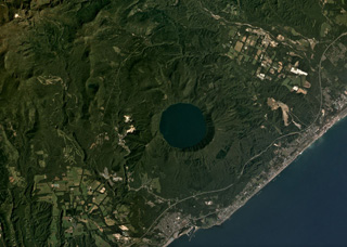 The 3-km-wide Kuttara caldera formed 40,000 years ago and contains Lake Kuttara, shown in this September 2019 Planet Labs satellite image monthly mosaic (N is at the top). The complex also contains cones, domes, and craters, and has ongoing geothermal activity. The Noboribetsu geothermal field and the Hiyoriyama Cryptodome are on the W flank, approximately 1.3 km from the lake edge in this view.
The following 4 samples associated with this volcano can be found in the Smithsonian's NMNH Department of Mineral Sciences collections, and may be availble for research (contact the Rock and Ore Collections Manager). Catalog number links will open a window with more information.
| Catalog Number | Sample Description | Lava Source | Collection Date |
|---|---|---|---|
| NMNH 112876 | Hornblende Dacite | NOBORIBETSU THERMAL AREA | -- |
| NMNH 112876 | Hornblende Dacite | NOBORIBETSU THERMAL AREA | -- |
| NMNH 112877 | Andesite | NOBORIBETSU THERMAL AREA | -- |
| NMNH 112877 | Andesite | NOBORIBETSU THERMAL AREA | -- |
| Copernicus Browser | The Copernicus Browser replaced the Sentinel Hub Playground browser in 2023, to provide access to Earth observation archives from the Copernicus Data Space Ecosystem, the main distribution platform for data from the EU Copernicus missions. |
| MIROVA | Middle InfraRed Observation of Volcanic Activity (MIROVA) is a near real time volcanic hot-spot detection system based on the analysis of MODIS (Moderate Resolution Imaging Spectroradiometer) data. In particular, MIROVA uses the Middle InfraRed Radiation (MIR), measured over target volcanoes, in order to detect, locate and measure the heat radiation sourced from volcanic activity. |
| MODVOLC Thermal Alerts | Using infrared satellite Moderate Resolution Imaging Spectroradiometer (MODIS) data, scientists at the Hawai'i Institute of Geophysics and Planetology, University of Hawai'i, developed an automated system called MODVOLC to map thermal hot-spots in near real time. For each MODIS image, the algorithm automatically scans each 1 km pixel within it to check for high-temperature hot-spots. When one is found the date, time, location, and intensity are recorded. MODIS looks at every square km of the Earth every 48 hours, once during the day and once during the night, and the presence of two MODIS sensors in space allows at least four hot-spot observations every two days. Each day updated global maps are compiled to display the locations of all hot spots detected in the previous 24 hours. There is a drop-down list with volcano names which allow users to 'zoom-in' and examine the distribution of hot-spots at a variety of spatial scales. |
|
WOVOdat
Single Volcano View Temporal Evolution of Unrest Side by Side Volcanoes |
WOVOdat is a database of volcanic unrest; instrumentally and visually recorded changes in seismicity, ground deformation, gas emission, and other parameters from their normal baselines. It is sponsored by the World Organization of Volcano Observatories (WOVO) and presently hosted at the Earth Observatory of Singapore.
GVMID Data on Volcano Monitoring Infrastructure The Global Volcano Monitoring Infrastructure Database GVMID, is aimed at documenting and improving capabilities of volcano monitoring from the ground and space. GVMID should provide a snapshot and baseline view of the techniques and instrumentation that are in place at various volcanoes, which can be use by volcano observatories as reference to setup new monitoring system or improving networks at a specific volcano. These data will allow identification of what monitoring gaps exist, which can be then targeted by remote sensing infrastructure and future instrument deployments. |
| Volcanic Hazard Maps | The IAVCEI Commission on Volcanic Hazards and Risk has a Volcanic Hazard Maps database designed to serve as a resource for hazard mappers (or other interested parties) to explore how common issues in hazard map development have been addressed at different volcanoes, in different countries, for different hazards, and for different intended audiences. In addition to the comprehensive, searchable Volcanic Hazard Maps Database, this website contains information about diversity of volcanic hazard maps, illustrated using examples from the database. This site is for educational purposes related to volcanic hazard maps. Hazard maps found on this website should not be used for emergency purposes. For the most recent, official hazard map for a particular volcano, please seek out the proper institutional authorities on the matter. |
| IRIS seismic stations/networks | Incorporated Research Institutions for Seismology (IRIS) Data Services map showing the location of seismic stations from all available networks (permanent or temporary) within a radius of 0.18° (about 20 km at mid-latitudes) from the given location of Kuttara. Users can customize a variety of filters and options in the left panel. Note that if there are no stations are known the map will default to show the entire world with a "No data matched request" error notice. |
| UNAVCO GPS/GNSS stations | Geodetic Data Services map from UNAVCO showing the location of GPS/GNSS stations from all available networks (permanent or temporary) within a radius of 20 km from the given location of Kuttara. Users can customize the data search based on station or network names, location, and time window. Requires Adobe Flash Player. |
| DECADE Data | The DECADE portal, still in the developmental stage, serves as an example of the proposed interoperability between The Smithsonian Institution's Global Volcanism Program, the Mapping Gas Emissions (MaGa) Database, and the EarthChem Geochemical Portal. The Deep Earth Carbon Degassing (DECADE) initiative seeks to use new and established technologies to determine accurate global fluxes of volcanic CO2 to the atmosphere, but installing CO2 monitoring networks on 20 of the world's 150 most actively degassing volcanoes. The group uses related laboratory-based studies (direct gas sampling and analysis, melt inclusions) to provide new data for direct degassing of deep earth carbon to the atmosphere. |
| Large Eruptions of Kuttara | Information about large Quaternary eruptions (VEI >= 4) is cataloged in the Large Magnitude Explosive Volcanic Eruptions (LaMEVE) database of the Volcano Global Risk Identification and Analysis Project (VOGRIPA). |
| EarthChem | EarthChem develops and maintains databases, software, and services that support the preservation, discovery, access and analysis of geochemical data, and facilitate their integration with the broad array of other available earth science parameters. EarthChem is operated by a joint team of disciplinary scientists, data scientists, data managers and information technology developers who are part of the NSF-funded data facility Integrated Earth Data Applications (IEDA). IEDA is a collaborative effort of EarthChem and the Marine Geoscience Data System (MGDS). |

