

AVO reported that earthquake activity near Takawangha had decreased in both rate and magnitude. The rate of earthquakes had been about three events per day during the previous three weeks, much lower than the 150 events per day recorded during the peak of the swarm in mid-March. Recent satellite images did not indicate any deformation on the island and no other signs of volcanic unrest had been detected. On 18 July the Volcano Alert Level was lowered to Normal (the lowest level on a four-level scale) and the Aviation Color Code was lowered to Green (the lowest color on a four-color scale).
Source: US Geological Survey Alaska Volcano Observatory (AVO)
2023: March
| July
2022: November
2017: January
| February
AVO reported that earthquake activity near Takawangha had decreased in both rate and magnitude. The rate of earthquakes had been about three events per day during the previous three weeks, much lower than the 150 events per day recorded during the peak of the swarm in mid-March. Recent satellite images did not indicate any deformation on the island and no other signs of volcanic unrest had been detected. On 18 July the Volcano Alert Level was lowered to Normal (the lowest level on a four-level scale) and the Aviation Color Code was lowered to Green (the lowest color on a four-color scale).
Source: US Geological Survey Alaska Volcano Observatory (AVO)
AVO reported that earthquake activity near Takawangha had decreased in both rate and magnitude from the peak of the swarm recorded during 9-11 March. More than 800 earthquakes, including multiple M2 and above events, were detected beneath Tanaga Island at depths less than 9 km below sea level during 11-17 March. The decline in activity decreased the potential for an eruption, so AVO lowered the Volcano Alert Level to Advisory (the second lowest level on a four-level scale) and the Aviation Color Code to Yellow (the second lowest color on a four-color scale) on 16 March. The Volcano Alert Level and Aviation Color Code for Tanaga (8 km W) were also lowered to the same level. Several M 2 and higher earthquakes were detected during 17-18 March, in addition to numerous smaller events. Earthquake activity persisted through 20 March.
Source: US Geological Survey Alaska Volcano Observatory (AVO)
AVO reported that the earthquake swarm at Takawangha that began in November 2022 started to decline on 1 March. Seismicity abruptly increased again on 8 March and was sustained, with M4 or lower earthquakes occurring at depths of less than about 6 km below sea level. Earthquake activity beneath Takawangha volcano and nearby Tanaga Volcano (8 km W), both on Tanaga Island, continued at a high rate during 8-9 March, with more than 100 events per hour at times. Sustained seismicity indicated an increased potential for an eruption, so AVO raised the Volcano Alert Level for Takawangha to Watch (the second highest level on a four-level scale) and the Aviation Color Code to Orange (the second highest level on a four-color scale) at 1722 on 9 March. It was uncertain which volcano would erupt, if an eruption were to occur, so the Volcano Alert Level and Aviation Color Code for Tanaga were also raised to the same level. Earthquakes beneath Tanaga and Takawangha occurred at a rate of up to several events per minute during 10-11 March and at a slightly reduced rate during 12-14 March. The earthquakes had magnitudes up to about 4 and were mostly occurring at depths less than about 6 km.
Source: US Geological Survey Alaska Volcano Observatory (AVO)
AVO reported that the earthquake swarm at Takawangha that began in November 2022 was ongoing with 120 earthquakes located during 25 February-3 March. The number of events per day was highest on 28 February and 1 March, with over 50 earthquakes located on each of those days. Three earthquakes had magnitudes greater than 3, occurred at shallow depths of less than 6 km, and were located about 6 km E of the volcano. During 3-7 March small daily earthquakes with magnitudes less than M2 occurred in the vicinity of the volcano. The Aviation Color Code remained at Yellow (the second lowest level on a four-color scale) and the Volcano Alert Level remained at Advisory (the second lowest level on a four-level scale).
Source: US Geological Survey Alaska Volcano Observatory (AVO)
On 18 November AVO raised the Aviation Color Code for Takawangha to Yellow (the second lowest level on a four-color scale) and the Volcano Alert Level to Advisory (the second lowest level on a four-level scale) based on increased seismicity. The number of small earthquakes detected near the volcano had increased during the previous few days and intensified during 17-18 November. The earthquakes were located at depths of 3-6 km below sea level with the largest magnitudes between 2 and 3. The seismicity possibly indicated magma movement at depth. The intensity of the seismicity was variable during 19-22 November.
Source: US Geological Survey Alaska Volcano Observatory (AVO)
On 10 February AVO stated that the seismic swarm that began at Takawangha on 23 January had significantly declined the previous week and that seismicity was nearly at background levels. The Aviation Color Code was lowered to Green and the Volcano Alert Level was lowered to Normal.
Source: US Geological Survey Alaska Volcano Observatory (AVO)
On 3 February AVO stated that the seismic swarm that began at Takawangha on 23 January continued but at a decreased rate and intensity. The rate of earthquakes peaked at 190 events on 24 January, and since then had steadily declined; 2-8 events per day were recorded from late January to 3 February. Most of the events were located 7-8 km ESE, at shallow depths. The Aviation Color Code remained at Yellow and the Volcano Alert Level remained at Advisory.
Source: US Geological Survey Alaska Volcano Observatory (AVO)
On 27 January AVO stated that the seismic swarm that began at Takawangha on 23 January had significantly decreased during the previous day. The rate of earthquakes peaked at 190 events on 24 January and had steadily decreased to 22 detected on 27 January. Most of the events were located 7-8 km ESE, at shallow depths. The swarm continued at a decreased rate and intensity through 31 January. The Aviation Color Code remained at Yellow and the Volcano Alert Level remained at Advisory.
Source: US Geological Survey Alaska Volcano Observatory (AVO)
AVO reported that an energetic earthquake swarm on Tanaga Island began on 23 January, with earthquakes located 6-7 km ESE of Takawangha volcano, and was possibly due to brittle failure in the surrounding rock caused by magma movement. AVO raised the Aviation Color Code to Yellow and Alert Level to Advisory.
Source: US Geological Survey Alaska Volcano Observatory (AVO)
The Global Volcanism Program has no Bulletin Reports available for Takawangha.
|
|
||||||||||||||||||||||||||||
There is data available for 1 confirmed eruptive period.
1550 (?) Confirmed Eruption (Explosive / Effusive)
| Episode 1 | Eruption (Explosive / Effusive) | |||||||||||||||||||
|---|---|---|---|---|---|---|---|---|---|---|---|---|---|---|---|---|---|---|---|
| 1550 (?) - Unknown | Evidence from Isotopic: 14C (uncalibrated) | ||||||||||||||||||
|
List of 2 Events for Episode 1
|
|||||||||||||||||||
The Global Volcanism Program has no synonyms or subfeatures listed for Takawangha.
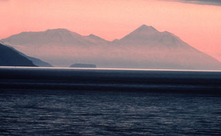 Takawangha volcano (left), seen here from the E, has an ice-filled caldera on northern Tanaga Island. Numerous small cones are located within the caldera, as well as on the rim and flanks. Tanaga volcano is to the right.
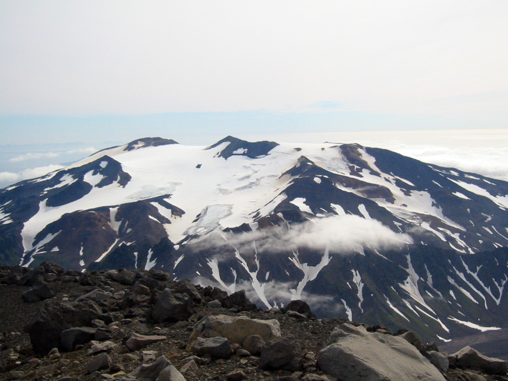
 Takawangha is seen here looking E from the summit of East Tanaga. It lies across a saddle from historically active Tanaga volcano to the west. The summit has five Holocene craters that produced explosive eruptions and lava flows that reached the lower flanks during the last few thousand years.
 There are no samples for Takawangha in the Smithsonian's NMNH Department of Mineral Sciences Rock and Ore collection.
| Alaska Volcano Observatory (Link to Takawangha) | The Alaska Volcano Observatory (AVO) is a joint program of the U.S. Geological Survey (USGS), the Geophysical Institute of the University of Alaska Fairbanks (UAFGI), and the State of Alaska Division of Geological and Geophysical Surveys (ADGGS). AVO was formed in 1988, and uses federal, state, and university resources to monitor and study Alaska's hazardous volcanoes, to predict and record eruptive activity, and to mitigate volcanic hazards to life and property. |
| Copernicus Browser | The Copernicus Browser replaced the Sentinel Hub Playground browser in 2023, to provide access to Earth observation archives from the Copernicus Data Space Ecosystem, the main distribution platform for data from the EU Copernicus missions. |
| MIROVA | Middle InfraRed Observation of Volcanic Activity (MIROVA) is a near real time volcanic hot-spot detection system based on the analysis of MODIS (Moderate Resolution Imaging Spectroradiometer) data. In particular, MIROVA uses the Middle InfraRed Radiation (MIR), measured over target volcanoes, in order to detect, locate and measure the heat radiation sourced from volcanic activity. |
| MODVOLC Thermal Alerts | Using infrared satellite Moderate Resolution Imaging Spectroradiometer (MODIS) data, scientists at the Hawai'i Institute of Geophysics and Planetology, University of Hawai'i, developed an automated system called MODVOLC to map thermal hot-spots in near real time. For each MODIS image, the algorithm automatically scans each 1 km pixel within it to check for high-temperature hot-spots. When one is found the date, time, location, and intensity are recorded. MODIS looks at every square km of the Earth every 48 hours, once during the day and once during the night, and the presence of two MODIS sensors in space allows at least four hot-spot observations every two days. Each day updated global maps are compiled to display the locations of all hot spots detected in the previous 24 hours. There is a drop-down list with volcano names which allow users to 'zoom-in' and examine the distribution of hot-spots at a variety of spatial scales. |
|
WOVOdat
Single Volcano View Temporal Evolution of Unrest Side by Side Volcanoes |
WOVOdat is a database of volcanic unrest; instrumentally and visually recorded changes in seismicity, ground deformation, gas emission, and other parameters from their normal baselines. It is sponsored by the World Organization of Volcano Observatories (WOVO) and presently hosted at the Earth Observatory of Singapore.
GVMID Data on Volcano Monitoring Infrastructure The Global Volcano Monitoring Infrastructure Database GVMID, is aimed at documenting and improving capabilities of volcano monitoring from the ground and space. GVMID should provide a snapshot and baseline view of the techniques and instrumentation that are in place at various volcanoes, which can be use by volcano observatories as reference to setup new monitoring system or improving networks at a specific volcano. These data will allow identification of what monitoring gaps exist, which can be then targeted by remote sensing infrastructure and future instrument deployments. |
| Volcanic Hazard Maps | The IAVCEI Commission on Volcanic Hazards and Risk has a Volcanic Hazard Maps database designed to serve as a resource for hazard mappers (or other interested parties) to explore how common issues in hazard map development have been addressed at different volcanoes, in different countries, for different hazards, and for different intended audiences. In addition to the comprehensive, searchable Volcanic Hazard Maps Database, this website contains information about diversity of volcanic hazard maps, illustrated using examples from the database. This site is for educational purposes related to volcanic hazard maps. Hazard maps found on this website should not be used for emergency purposes. For the most recent, official hazard map for a particular volcano, please seek out the proper institutional authorities on the matter. |
| IRIS seismic stations/networks | Incorporated Research Institutions for Seismology (IRIS) Data Services map showing the location of seismic stations from all available networks (permanent or temporary) within a radius of 0.18° (about 20 km at mid-latitudes) from the given location of Takawangha. Users can customize a variety of filters and options in the left panel. Note that if there are no stations are known the map will default to show the entire world with a "No data matched request" error notice. |
| UNAVCO GPS/GNSS stations | Geodetic Data Services map from UNAVCO showing the location of GPS/GNSS stations from all available networks (permanent or temporary) within a radius of 20 km from the given location of Takawangha. Users can customize the data search based on station or network names, location, and time window. Requires Adobe Flash Player. |
| DECADE Data | The DECADE portal, still in the developmental stage, serves as an example of the proposed interoperability between The Smithsonian Institution's Global Volcanism Program, the Mapping Gas Emissions (MaGa) Database, and the EarthChem Geochemical Portal. The Deep Earth Carbon Degassing (DECADE) initiative seeks to use new and established technologies to determine accurate global fluxes of volcanic CO2 to the atmosphere, but installing CO2 monitoring networks on 20 of the world's 150 most actively degassing volcanoes. The group uses related laboratory-based studies (direct gas sampling and analysis, melt inclusions) to provide new data for direct degassing of deep earth carbon to the atmosphere. |
| Large Eruptions of Takawangha | Information about large Quaternary eruptions (VEI >= 4) is cataloged in the Large Magnitude Explosive Volcanic Eruptions (LaMEVE) database of the Volcano Global Risk Identification and Analysis Project (VOGRIPA). |
| EarthChem | EarthChem develops and maintains databases, software, and services that support the preservation, discovery, access and analysis of geochemical data, and facilitate their integration with the broad array of other available earth science parameters. EarthChem is operated by a joint team of disciplinary scientists, data scientists, data managers and information technology developers who are part of the NSF-funded data facility Integrated Earth Data Applications (IEDA). IEDA is a collaborative effort of EarthChem and the Marine Geoscience Data System (MGDS). |