

AVO reported that on 26 October strong winds in areas NW of Aniakchak and E of Port Heiden dispersed unconsolidated ash up to 0.9 km (3,000 ft) a.s.l. to the NW. The ash cloud was visible in satellite images and in Port Heiden webcam views. The Volcano Alert Level remained at Normal (the lowest level on a four-level scale) and the Aviation Color Code remained at Green (the lowest level on a four-color scale). Equipment failed on 30 October, so AVO could no longer seismically monitor the volcano at an adequate level and determine if activity was at a typical background level. Both the Volcano Alert Level and the Aviation Color Code were changed to Unassigned.
Source: US Geological Survey Alaska Volcano Observatory (AVO)
2023: February
| March
| April
| August
| October
2022: June
2021: July
AVO reported that on 26 October strong winds in areas NW of Aniakchak and E of Port Heiden dispersed unconsolidated ash up to 0.9 km (3,000 ft) a.s.l. to the NW. The ash cloud was visible in satellite images and in Port Heiden webcam views. The Volcano Alert Level remained at Normal (the lowest level on a four-level scale) and the Aviation Color Code remained at Green (the lowest level on a four-color scale). Equipment failed on 30 October, so AVO could no longer seismically monitor the volcano at an adequate level and determine if activity was at a typical background level. Both the Volcano Alert Level and the Aviation Color Code were changed to Unassigned.
Source: US Geological Survey Alaska Volcano Observatory (AVO)
On 17 August AVO reported that number of earthquakes beneath Aniakchak and the measurable uplift of the ground surface in the caldera had declined to background levels. The Aviation Color Code was lowered to Green (the lowest level on a four-color scale) and the Volcano Alert Level was lowered to Normal (the lowest level on a four-level scale).
Source: US Geological Survey Alaska Volcano Observatory (AVO)
On 13 April AVO issued an Information Statement about the ongoing unrest at Aniakchak. Measurements of the earthquake rate in the ongoing swarm were disrupted by a partial network outage that began on 4 March and reduced the ability to detect smaller earthquakes. Earthquake activity continued to be above background levels with a M 3.3 on 6 April as the largest recent event. In addition to the earthquake swarm, high rates of deformation were detected in radar data. A zone of uplift centered within the W side of the caldera was first detected between 4 and 27 February. The ground uplift rates were about 4 cm per week during February-March and about 3 cm per week during 23 March-4 April. These uplift rates are at the high end of those observed for restless volcanoes worldwide.
Seismic and deformation data suggested that magma was intruding beneath the caldera at a depth of 3-4 km below sea level. AVO noted that unrest at calderas such as Aniakchak sometimes lasts for many months or even years and could be variable . If an eruption were to occur, it could be after a period of months or years and would likely be preceded by additional signals that would allow AVO to provide advance warning. Aniakchak has a local monitoring network consisting of six seismometers, a web camera, and an infrasound sensor, as well as with satellite remote sensing data and regional infrasound and lightning networks. AVO recently installed an additional seismic station and web camera in Port Heiden, 26 km NW. The Aviation Color Code remained at Yellow (the second lowest level on a four-color scale) and the Volcano Alert Level remained at Advisory (the second lowest level on a four-level scale).
Source: US Geological Survey Alaska Volcano Observatory (AVO)
AVO reported that the earthquake swarm at Aniakchak was ongoing with 120 earthquakes located during 25 February-3 March. Magnitudes were as high as M3.1 and several earthquakes had magnitudes between M2 and M3. The earthquakes were located at shallow depths (less than 5 km) and below the S part of the caldera and to the E of the volcano. Daily, small, shallow earthquakes with magnitudes as high as M2.7 were recorded during 4-7 March. The Aviation Color Code remained at Yellow (the second lowest level on a four-color scale) and the Volcano Alert Level remained at Advisory (the second lowest level on a four-level scale).
Source: US Geological Survey Alaska Volcano Observatory (AVO)
On 22 February AVO raised the Aviation Color Code for Aniakchak to Yellow (the second lowest level on a four-color scale) and the Volcano Alert Level to Advisory (the second lowest level on a four-level scale) due to a recent increase in the number of earthquakes and a shallowing of those events. Background seismicity was generally characterized as deep (more than 15 km below sea level) long-period events occurring at a rate of about four events per month. Beginning in October 2022 the rate increased, and the earthquakes were located at depths less than 9 km below sea level. The earthquake rate further increased on 31 January and was sustained with dozens of earthquakes detected per day, including a M 3.7 earthquake recorded on 17 February.
Elevated seismicity continued during 23-27 February at a variable rate. Dozens of earthquakes were recorded daily during 22-26 February, though more than one hundred small earthquakes (not all locatable) were detected during 24-25 February. Small earthquakes occurred at the rate of about 10 per hour during 26-28 February. AVO noted that there was no indication that an eruption of Aniakchak was imminent, or that one will occur. Increases in seismic activity have been detected previously at other similar volcanoes, with no subsequent eruptions.
Source: US Geological Survey Alaska Volcano Observatory (AVO)
AVO reported that strong winds in a region NW of Aniakchak and E of Port Heiden resuspended ash and blew it NW on 30 June. A dense cloud of possible resuspended ash near ground levels was identified in Port Heiden webcam views. The altitude of the cloud was unknown, though the report noted that resuspended ash clouds typically do not rise above 5 km (16,400 ft) a.s.l. The cloud was not a result of volcanic activity; the Aviation Color Code and the Volcano Alert Level remained at Green and Normal, respectively.
Source: US Geological Survey Alaska Volcano Observatory (AVO)
AVO reported that strong winds in a region N of Aniakchak and E of Port Heiden resuspended ash and blew it N on 2 August. A dense cloud of possible resuspended ash near ground levels was identified in Port Heiden webcam views. The cloud was also visible in satellite data drifting about 200 km N. The report noted that resuspended ash clouds typically do not rise above 5 km (16,400 ft) a.s.l. The cloud was not a result of volcanic activity; the Aviation Color Code and the Volcano Alert Level remained at Green and Normal, respectively.
Source: US Geological Survey Alaska Volcano Observatory (AVO)
The Global Volcanism Program has no Bulletin Reports available for Aniakchak.
|
|
||||||||||||||||||||||||||||
There is data available for 16 confirmed eruptive periods.
[ 1951 Jun 25 - 1951 Jun 25 ] Discredited Eruption
Pilot Everett Skinner observed extensive brown haze that reduced visibility at Port Heiden airport to under 1/3 km. Airport officials attributed the haze to an eruption of Aniakchak volcano (BVE). This event was determined by Cameron (2004, pers. comm.) to have been a result of resuspended ash.
[ 1942 ] Uncertain Eruption
| Episode 1 | Uncertain | ||||
|---|---|---|---|---|
| 1942 - Unknown | Evidence from Unknown | |||
| Decker (1971) listed a 1942? eruption not mentioned by Miller et al. (1998). | ||||
1931 May 1 - 1931 Jun 13 (on or after) Confirmed Eruption (Explosive / Effusive) VEI: 4
| Episode 1 | Eruption (Explosive / Effusive) | West and SW caldera floor | ||||||||||||||||||||||||||||||||||||||||||||||||||||||||||||||||||||||||||||||||||||||||
|---|---|---|---|---|---|---|---|---|---|---|---|---|---|---|---|---|---|---|---|---|---|---|---|---|---|---|---|---|---|---|---|---|---|---|---|---|---|---|---|---|---|---|---|---|---|---|---|---|---|---|---|---|---|---|---|---|---|---|---|---|---|---|---|---|---|---|---|---|---|---|---|---|---|---|---|---|---|---|---|---|---|---|---|---|---|---|---|---|---|
| 1931 May 1 - 1931 Jun 13 (on or after) | Evidence from Observations: Reported | ||||||||||||||||||||||||||||||||||||||||||||||||||||||||||||||||||||||||||||||||||||||||
|
List of 16 Events for Episode 1 at West and SW caldera floor
|
|||||||||||||||||||||||||||||||||||||||||||||||||||||||||||||||||||||||||||||||||||||||||
1540 ± 100 years Confirmed Eruption (Explosive / Effusive) VEI: 4
| Episode 1 | Eruption (Explosive / Effusive) | NW & S caldera floor (Half Cone, Vent Mtn) | |||||||||||||||||||||||||||||||||
|---|---|---|---|---|---|---|---|---|---|---|---|---|---|---|---|---|---|---|---|---|---|---|---|---|---|---|---|---|---|---|---|---|---|---|
| 1540 ± 100 years - Unknown | Evidence from Isotopic: 14C (calibrated) | |||||||||||||||||||||||||||||||||
|
List of 5 Events for Episode 1 at NW & S caldera floor (Half Cone, Vent Mtn)
|
||||||||||||||||||||||||||||||||||
1470 ± 20 years Confirmed Eruption (Explosive / Effusive)
| Episode 1 | Eruption (Explosive / Effusive) | SE caldera floor (New Cone) | |||||||||||||
|---|---|---|---|---|---|---|---|---|---|---|---|---|---|---|
| 1470 ± 20 years - Unknown | Evidence from Isotopic: 14C (calibrated) | |||||||||||||
|
List of 1 Events for Episode 1 at SE caldera floor (New Cone)
|
||||||||||||||
1370 ± 55 years Confirmed Eruption (Explosive / Effusive)
| Episode 1 | Eruption (Explosive / Effusive) | NW caldera floor (Half Cone) | ||||||||||||||||||
|---|---|---|---|---|---|---|---|---|---|---|---|---|---|---|---|---|---|---|---|
| 1370 ± 55 years - Unknown | Evidence from Isotopic: 14C (calibrated) | ||||||||||||||||||
|
List of 2 Events for Episode 1 at NW caldera floor (Half Cone)
|
|||||||||||||||||||
1280 ± 145 years Confirmed Eruption (Explosive / Effusive)
| Episode 1 | Eruption (Explosive / Effusive) | NW caldera floor (Half Cone) | ||||||||||||||||||
|---|---|---|---|---|---|---|---|---|---|---|---|---|---|---|---|---|---|---|---|
| 1280 ± 145 years - Unknown | Evidence from Isotopic: 14C (calibrated) | ||||||||||||||||||
|
List of 2 Events for Episode 1 at NW caldera floor (Half Cone)
|
|||||||||||||||||||
1190 ± 30 years Confirmed Eruption (Explosive / Effusive)
| Episode 1 | Eruption (Explosive / Effusive) | NW caldera floor (Half Cone) | |||||||||||||||||||||||
|---|---|---|---|---|---|---|---|---|---|---|---|---|---|---|---|---|---|---|---|---|---|---|---|---|
| 1190 ± 30 years - Unknown | Evidence from Isotopic: 14C (calibrated) | |||||||||||||||||||||||
|
List of 3 Events for Episode 1 at NW caldera floor (Half Cone)
|
||||||||||||||||||||||||
1120 ± 80 years Confirmed Eruption (Explosive / Effusive)
| Episode 1 | Eruption (Explosive / Effusive) | East-central caldera (Surprise Cone) | ||||||||||||||||||
|---|---|---|---|---|---|---|---|---|---|---|---|---|---|---|---|---|---|---|---|
| 1120 ± 80 years - Unknown | Evidence from Isotopic: 14C (calibrated) | ||||||||||||||||||
|
List of 2 Events for Episode 1 at East-central caldera (Surprise Cone)
|
|||||||||||||||||||
1050 (?) Confirmed Eruption (Explosive / Effusive)
| Episode 1 | Eruption (Explosive / Effusive) | Vent Mtn and other vents? | ||||||||||||||||||
|---|---|---|---|---|---|---|---|---|---|---|---|---|---|---|---|---|---|---|---|
| 1050 (?) - Unknown | Evidence from Correlation: Tephrochronology | ||||||||||||||||||
|
List of 2 Events for Episode 1 at Vent Mtn and other vents?
|
|||||||||||||||||||
0700 ± 250 years Confirmed Eruption (Explosive / Effusive) VEI: 0
| Episode 1 | Eruption (Explosive / Effusive) | S & NW caldera floor (Vent Mtn & Half Cone) | ||||||||||||||||||
|---|---|---|---|---|---|---|---|---|---|---|---|---|---|---|---|---|---|---|---|
| 0700 ± 250 years - Unknown | Evidence from Correlation: Tephrochronology | ||||||||||||||||||
|
List of 2 Events for Episode 1 at S & NW caldera floor (Vent Mtn & Half Cone)
|
|||||||||||||||||||
0460 (?) Confirmed Eruption (Explosive / Effusive)
| Episode 1 | Eruption (Explosive / Effusive) | |||||||||||||||||||
|---|---|---|---|---|---|---|---|---|---|---|---|---|---|---|---|---|---|---|---|
| 0460 (?) - Unknown | Evidence from Isotopic: 14C (uncalibrated) | ||||||||||||||||||
|
List of 2 Events for Episode 1
|
|||||||||||||||||||
0200 ± 255 years Confirmed Eruption (Explosive / Effusive)
| Episode 1 | Eruption (Explosive / Effusive) | Northern & western caldera floor | ||||||||||||||||||
|---|---|---|---|---|---|---|---|---|---|---|---|---|---|---|---|---|---|---|---|
| 0200 ± 255 years - Unknown | Evidence from Correlation: Tephrochronology | ||||||||||||||||||
|
List of 2 Events for Episode 1 at Northern & western caldera floor
|
|||||||||||||||||||
0370 BCE ± 210 years Confirmed Eruption (Explosive / Effusive)
| Episode 1 | Eruption (Explosive / Effusive) | |||||||||||||||||||
|---|---|---|---|---|---|---|---|---|---|---|---|---|---|---|---|---|---|---|---|
| 0370 BCE ± 210 years - Unknown | Evidence from Isotopic: 14C (calibrated) | ||||||||||||||||||
|
List of 2 Events for Episode 1
|
|||||||||||||||||||
1645 BCE ± 10 years Confirmed Eruption (Explosive / Effusive) VEI: 6 (?)
| Episode 1 | Eruption (Explosive / Effusive) | |||||||||||||||||||||||||||||||||||||||||||||||||
|---|---|---|---|---|---|---|---|---|---|---|---|---|---|---|---|---|---|---|---|---|---|---|---|---|---|---|---|---|---|---|---|---|---|---|---|---|---|---|---|---|---|---|---|---|---|---|---|---|---|
| 1645 BCE ± 10 years - Unknown | Evidence from Sidereal: Ice Core | ||||||||||||||||||||||||||||||||||||||||||||||||
|
List of 8 Events for Episode 1
|
|||||||||||||||||||||||||||||||||||||||||||||||||
2550 BCE ± 500 years Confirmed Eruption (Explosive / Effusive)
| Episode 1 | Eruption (Explosive / Effusive) | ||||||||||||||
|---|---|---|---|---|---|---|---|---|---|---|---|---|---|---|
| 2550 BCE ± 500 years - Unknown | Evidence from Correlation: Tephrochronology | |||||||||||||
|
List of 1 Events for Episode 1
|
||||||||||||||
5930 BCE ± 240 years Confirmed Eruption (Explosive / Effusive)
| Episode 1 | Eruption (Explosive / Effusive) | Black Nose Pumice | |||||||||||||||||||||||
|---|---|---|---|---|---|---|---|---|---|---|---|---|---|---|---|---|---|---|---|---|---|---|---|---|
| 5930 BCE ± 240 years - Unknown | Evidence from Isotopic: 14C (calibrated) | |||||||||||||||||||||||
|
List of 3 Events for Episode 1 at Black Nose Pumice
|
||||||||||||||||||||||||
6300 BCE ± 1250 years Confirmed Eruption (Explosive / Effusive) VEI: 6 (?)
| Episode 1 | Eruption (Explosive / Effusive) | |||||||||||||||||||||||||||||
|---|---|---|---|---|---|---|---|---|---|---|---|---|---|---|---|---|---|---|---|---|---|---|---|---|---|---|---|---|---|
| 6300 BCE ± 1250 years - Unknown | Evidence from Correlation: Tephrochronology | ||||||||||||||||||||||||||||
|
List of 4 Events for Episode 1
|
|||||||||||||||||||||||||||||
This compilation of synonyms and subsidiary features may not be comprehensive. Features are organized into four major categories: Cones, Craters, Domes, and Thermal Features. Synonyms of features appear indented below the primary name. In some cases additional feature type, elevation, or location details are provided.
Cones |
||||
| Feature Name | Feature Type | Elevation | Latitude | Longitude |
| Blocky Cone | Cone | |||
| Breezy Cone | Tuff cone | |||
| Half Cone | Cone | |||
| New Cone | Cone | |||
| Surprise Cone | Tuff cone | 514 m | ||
| Vent Mountain | Cone | 1021 m | ||
| Windy Cone | Tuff cone | |||
Craters |
||||
| Feature Name | Feature Type | Elevation | Latitude | Longitude |
| Aniakchak | Caldera | |||
| NW Maar | Maar | |||
| SW Maar | Maar | |||
Domes |
||||
| Feature Name | Feature Type | Elevation | Latitude | Longitude |
| Bolshoi Dome | Dome | 440 m | ||
| Doublet Crater | Dome | |||
| Pumice Dome | Dome | |||
| Vulcan Dome | Dome | |||
| West Dome | Dome | 610 m | ||
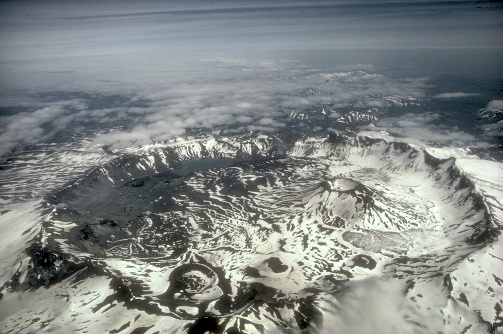
 The 10-km-wide Aniakchak caldera is one of the most dramatic volcanoes on the Alaska Peninsula. It was formed about 3400 years ago during an eruption in which voluminous pyroclastic flows reached the Bering Sea, 80 km away. This view from the NE shows the largest post-caldera volcano, Vent Mountain (upper right) and Surprise Lake (lower right), which drains through The Gates (left center), a steep-walled notch in the 1-km-high eastern caldera rim. The only historical eruption of Aniakchak took place in 1931.
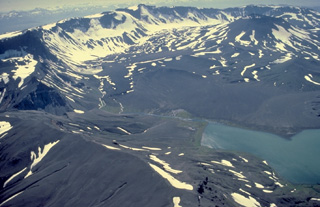
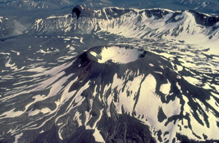 Vent Mountain, a post-caldera volcano that rises 450 m above the caldera floor, is the largest of a variety of volcanic features on the floor of the 10-km-wide caldera. In addition to Vent Mountain, the most prominent post-caldera features are Half Cone, on the NW side and a 1931 vent near the west rim. Lava flows, tuff cones, maars, cinder cones, and lava domes are all found within Aniakchak caldera. This view from the SW shows the east caldera rim, with The Gates, a steep-walled notch in the east rim, at the upper left.
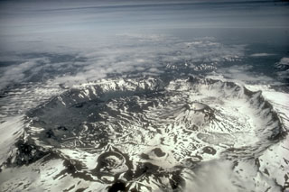 Aniakchak is a 10-km-wide summit caldera containing numerous cones, lava domes, and lava flows on the caldera floor. The largest intra-caldera cone is Vent Mountain that reaches 430 m in height and has a diameter at the base of 2.5 km. At least 20 Holocene eruptions may have occurred before the Aniakchak II caldera-forming eruption.
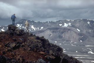 Volcanologists from the U.S. Geological Survey on the rim of the intra-caldera Vent Mountain at Aniakchak look NW towards Half Cone, a prominent feature on the caldera floor and the source of an explosive post-caldera eruption. The NW caldera rim of Aniakchak caldera forms the skyline.
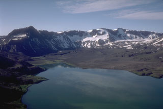 This view looks south across the caldera from the north rim of Aniakchak. The prominent dark peak on the skyline (left) is Black Nose, a remnant of pre-caldera volcaniclastics. A pumice-covered glacier and associated moraine is in the distance against the caldera wall. Surprise Lake once covered a much larger part of the caldera floor before catastrophically draining through a notch in the east caldera rim.
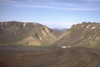 The Gates is a v-shaped notch in the 1-km-high eastern rim of Aniakchak caldera. Surprise Lake was once much larger but is now restricted to the NW part of the caldera floor. It is thought to have drained catastrophically through The Gates at the time of an eruption at Half Cone about 500 years ago.
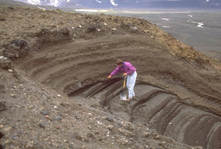 A geologist examines pyroclastic deposits (above hand) from a violent eruption of Half Cone less than 500 years ago. The Half Cone layers overlie dark gray phreatomagmatic deposits from Surprise tuff cone in Aniakchak caldera. The Half Cone eruption produced about 1 km3 of tephra and resulted in truncation of the SE side of the cone.
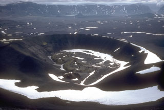 The primary Aniakchak 1931 eruption site is against the NW caldera wall. This 600-m-wide crater produced intermittent explosions of pumice-lithic tephra over the course of several weeks in May and June 1931. During the final phases of the eruption a small lava flow formed in the bottom of the crater. The fissure eruption cut through Vent Mountain and across the caldera floor to the western caldera wall.
The following 54 samples associated with this volcano can be found in the Smithsonian's NMNH Department of Mineral Sciences collections, and may be availble for research (contact the Rock and Ore Collections Manager). Catalog number links will open a window with more information.
| Catalog Number | Sample Description | Lava Source | Collection Date |
|---|---|---|---|
| NMNH 117233-106 | Pumice | -- | -- |
| NMNH 117233-107 | Pumice | -- | -- |
| NMNH 117233-108 | Pumice | -- | -- |
| NMNH 117233-109 | Pumice | -- | -- |
| NMNH 117233-110 | Pumice | -- | -- |
| NMNH 117233-111 | Pumice | -- | -- |
| NMNH 117233-112 | Pumice | -- | -- |
| NMNH 117233-113 | Pumice | -- | -- |
| NMNH 117233-114 | Pumice | -- | -- |
| NMNH 117233-115 | Pumice | -- | -- |
| NMNH 117233-116 | Pumice | -- | -- |
| NMNH 117233-117 | Pumice | -- | -- |
| NMNH 117233-118 | Pumice | -- | -- |
| NMNH 117233-119 | Basalt | -- | -- |
| NMNH 117233-120 | Pumice | -- | -- |
| NMNH 117233-121 | Pumice | -- | -- |
| NMNH 117233-122 | Tuff | -- | -- |
| NMNH 117233-123 | Pumice | -- | -- |
| NMNH 117233-124 | Pumice | -- | -- |
| NMNH 117233-125 | Pumice | -- | -- |
| NMNH 117233-126 | Pumice | -- | -- |
| NMNH 117233-127 | Basalt | -- | -- |
| NMNH 117233-128 | Dacite | -- | -- |
| NMNH 117233-131 | Obsidian | -- | -- |
| NMNH 117233-132 | Pumice | -- | -- |
| NMNH 117233-133 | Pumice | -- | -- |
| NMNH 117233-134 | Pumice | -- | -- |
| NMNH 117233-135 | Pumice | -- | -- |
| NMNH 117233-136 | Pumice | -- | -- |
| NMNH 117233-137 | Pumice | -- | -- |
| NMNH 117233-138 | Pumice | -- | -- |
| NMNH 117233-139 | Andesite | -- | -- |
| NMNH 117233-140 | Basalt | -- | -- |
| NMNH 117233-141 | Basalt | -- | -- |
| NMNH 117233-143 | Basalt | -- | -- |
| NMNH 117233-144 | Basalt | -- | -- |
| NMNH 117233-145 | Pumice | -- | -- |
| NMNH 117233-146 | Pumice | -- | -- |
| NMNH 117233-147 | Pumice | -- | -- |
| NMNH 117233-148 | Pumice | Aniakchak Ash Flow | -- |
| NMNH 117233-149 | Pumice | Aniakchak Ash Flow | -- |
| NMNH 117233-150 | Pumice | Aniakchak Ash Flow | -- |
| NMNH 117233-151 | Pumice | Aniakchak Ash Flow | -- |
| NMNH 117233-152 | Pumice | Aniakchak Ash Flow | -- |
| NMNH 117233-153 | Pumice | Aniakchak Ash Flow | -- |
| NMNH 117233-154 | Pumice | Aniakchak Ash Flow | -- |
| NMNH 117233-155 | Pumice | Aniakchak Ash Flow | -- |
| NMNH 117233-156 | Pumice | Aniakchak Ash Flow | -- |
| NMNH 117233-157 | Pumice | Aniakchak Ash Flow | -- |
| NMNH 117233-158 | Basalt | Aniakchak Ash Flow | -- |
| NMNH 117233-159 | Pumice | Aniakchak Ash Flow | -- |
| NMNH 117233-160 | Pumice | Aniakchak Ash Flow | -- |
| NMNH 117233-193 | Basalt | -- | -- |
| NMNH 117457-1 | Obsidian | -- | -- |
| Alaska Volcano Observatory (Link to Aniakchak) | The Alaska Volcano Observatory (AVO) is a joint program of the U.S. Geological Survey (USGS), the Geophysical Institute of the University of Alaska Fairbanks (UAFGI), and the State of Alaska Division of Geological and Geophysical Surveys (ADGGS). AVO was formed in 1988, and uses federal, state, and university resources to monitor and study Alaska's hazardous volcanoes, to predict and record eruptive activity, and to mitigate volcanic hazards to life and property. |
| Copernicus Browser | The Copernicus Browser replaced the Sentinel Hub Playground browser in 2023, to provide access to Earth observation archives from the Copernicus Data Space Ecosystem, the main distribution platform for data from the EU Copernicus missions. |
| MIROVA | Middle InfraRed Observation of Volcanic Activity (MIROVA) is a near real time volcanic hot-spot detection system based on the analysis of MODIS (Moderate Resolution Imaging Spectroradiometer) data. In particular, MIROVA uses the Middle InfraRed Radiation (MIR), measured over target volcanoes, in order to detect, locate and measure the heat radiation sourced from volcanic activity. |
| MODVOLC Thermal Alerts | Using infrared satellite Moderate Resolution Imaging Spectroradiometer (MODIS) data, scientists at the Hawai'i Institute of Geophysics and Planetology, University of Hawai'i, developed an automated system called MODVOLC to map thermal hot-spots in near real time. For each MODIS image, the algorithm automatically scans each 1 km pixel within it to check for high-temperature hot-spots. When one is found the date, time, location, and intensity are recorded. MODIS looks at every square km of the Earth every 48 hours, once during the day and once during the night, and the presence of two MODIS sensors in space allows at least four hot-spot observations every two days. Each day updated global maps are compiled to display the locations of all hot spots detected in the previous 24 hours. There is a drop-down list with volcano names which allow users to 'zoom-in' and examine the distribution of hot-spots at a variety of spatial scales. |
|
WOVOdat
Single Volcano View Temporal Evolution of Unrest Side by Side Volcanoes |
WOVOdat is a database of volcanic unrest; instrumentally and visually recorded changes in seismicity, ground deformation, gas emission, and other parameters from their normal baselines. It is sponsored by the World Organization of Volcano Observatories (WOVO) and presently hosted at the Earth Observatory of Singapore.
GVMID Data on Volcano Monitoring Infrastructure The Global Volcano Monitoring Infrastructure Database GVMID, is aimed at documenting and improving capabilities of volcano monitoring from the ground and space. GVMID should provide a snapshot and baseline view of the techniques and instrumentation that are in place at various volcanoes, which can be use by volcano observatories as reference to setup new monitoring system or improving networks at a specific volcano. These data will allow identification of what monitoring gaps exist, which can be then targeted by remote sensing infrastructure and future instrument deployments. |
| Volcanic Hazard Maps | The IAVCEI Commission on Volcanic Hazards and Risk has a Volcanic Hazard Maps database designed to serve as a resource for hazard mappers (or other interested parties) to explore how common issues in hazard map development have been addressed at different volcanoes, in different countries, for different hazards, and for different intended audiences. In addition to the comprehensive, searchable Volcanic Hazard Maps Database, this website contains information about diversity of volcanic hazard maps, illustrated using examples from the database. This site is for educational purposes related to volcanic hazard maps. Hazard maps found on this website should not be used for emergency purposes. For the most recent, official hazard map for a particular volcano, please seek out the proper institutional authorities on the matter. |
| IRIS seismic stations/networks | Incorporated Research Institutions for Seismology (IRIS) Data Services map showing the location of seismic stations from all available networks (permanent or temporary) within a radius of 0.18° (about 20 km at mid-latitudes) from the given location of Aniakchak. Users can customize a variety of filters and options in the left panel. Note that if there are no stations are known the map will default to show the entire world with a "No data matched request" error notice. |
| UNAVCO GPS/GNSS stations | Geodetic Data Services map from UNAVCO showing the location of GPS/GNSS stations from all available networks (permanent or temporary) within a radius of 20 km from the given location of Aniakchak. Users can customize the data search based on station or network names, location, and time window. Requires Adobe Flash Player. |
| DECADE Data | The DECADE portal, still in the developmental stage, serves as an example of the proposed interoperability between The Smithsonian Institution's Global Volcanism Program, the Mapping Gas Emissions (MaGa) Database, and the EarthChem Geochemical Portal. The Deep Earth Carbon Degassing (DECADE) initiative seeks to use new and established technologies to determine accurate global fluxes of volcanic CO2 to the atmosphere, but installing CO2 monitoring networks on 20 of the world's 150 most actively degassing volcanoes. The group uses related laboratory-based studies (direct gas sampling and analysis, melt inclusions) to provide new data for direct degassing of deep earth carbon to the atmosphere. |
| Large Eruptions of Aniakchak | Information about large Quaternary eruptions (VEI >= 4) is cataloged in the Large Magnitude Explosive Volcanic Eruptions (LaMEVE) database of the Volcano Global Risk Identification and Analysis Project (VOGRIPA). |
| EarthChem | EarthChem develops and maintains databases, software, and services that support the preservation, discovery, access and analysis of geochemical data, and facilitate their integration with the broad array of other available earth science parameters. EarthChem is operated by a joint team of disciplinary scientists, data scientists, data managers and information technology developers who are part of the NSF-funded data facility Integrated Earth Data Applications (IEDA). IEDA is a collaborative effort of EarthChem and the Marine Geoscience Data System (MGDS). |