The Global Volcanism Program has no activity reports available for Washington.
The Global Volcanism Program has no Weekly Reports available for Washington.
The Global Volcanism Program has no Bulletin Reports available for Washington.
|
|
||||||||||||||||||
The Global Volcanism Program is not aware of any Holocene eruptions from Washington. If this volcano has had large eruptions (VEI >= 4) prior to 12,000 years ago, information might be found on the Washington page in the LaMEVE (Large Magnitude Explosive Volcanic Eruptions) database, a part of the Volcano Global Risk Identification and Analysis Project (VOGRIPA).
This compilation of synonyms and subsidiary features may not be comprehensive. Features are organized into four major categories: Cones, Craters, Domes, and Thermal Features. Synonyms of features appear indented below the primary name. In some cases additional feature type, elevation, or location details are provided.
Cones |
||||
| Feature Name | Feature Type | Elevation | Latitude | Longitude |
| Cache Mountain | Pyroclastic cone | 1700 m | 44° 23' 0.00" N | 121° 47' 0.00" W |
| Hayrick Butte | Pyroclastic cone | 1683 m | 44° 24' 0.00" N | 121° 52' 0.00" W |
| Hoodoo Butte | Tuya | 1738 m | 44° 24' 0.00" N | 121° 53' 0.00" W |
| Little Cache Mountain | Pyroclastic cone | 1730 m | 44° 22' 0.00" N | 121° 48' 0.00" W |
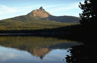 Mount Washington, reflected here in Big Lake on its NW side, is a Pleistocene shield volcano deeply dissected by glaciers. Erosion has exposed many dikes in the summit cone, which has not erupted since the late Pleistocene. Vents on the NE flank, behind the ridge on the left, erupted about 1300 years ago, probably as part of a a fissure-fed eruption at Blue Lake Crater.
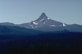 The sharp-topped pinnacle of Mount Washington, seen here from east of Santiam Pass on its NE, is a lava plug that caps a heavily eroded shield volcano. The steep-sided lava plug forming the summit was the last major Oregon peak to be climbed, resisting ascent until 1923.
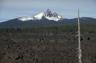 The dramatic summit pinnacle of Mount Washington is a central lava plug that caps a shield volcano. Mount Washington has been extensively dissected by glacial erosion, revealing the inner structure of the volcano. Fresh lava flows from cinder cones near North Sister volcano appear in the foreground of this view from the SE.
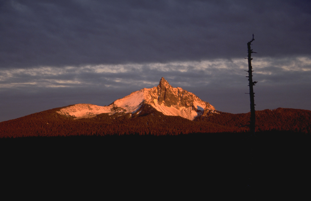
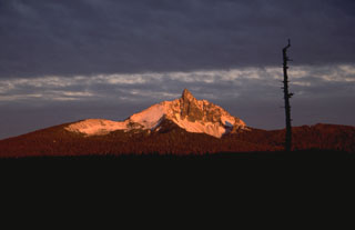 Early morning alpenglow gilds the summit of Mount Washington, one of the most distinctive landmarks of the central Oregon Cascades. Mount Washington is an extensively eroded basaltic shield volcano capped by a steep-sided central plug. The central edifice has not been active since the late Pleistocene, but a series of small spatter cones on its NE flank about 4 km from the summit erupted some 1300 years ago.
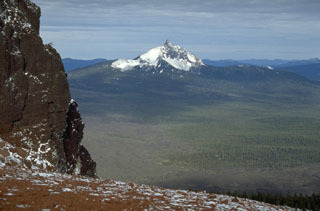 Mount Washington, seen here from Black Butte to the SE, is an eroded Pleistocene shield volcano capped by a steep central lava plug. NE flank spatter cones were active about 1300 years ago. Fresh lava flows in the foreground of this photo originated from Belknap volcano and cinder cones near North Sister volcano.
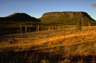 The contrasting morphology of rounded Hayrick Butte on the left and flat-topped Hoodoo Butte on the right, north of Mount Washington in the central Oregon Cascades, reflects dramatic differences in their origin. Hoodoo Butte is a "tuya," a volcanic cone formed by eruptions that ponded in a cavity melted through a glacial ice sheet. Hayrick Butte formed slightly later, when the Pleistocene ice sheet had melted, and formed the classic rounded profile of a scoria cone.
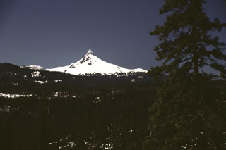 Early spring snows linger on the dramatic spine of Mount Washington, seen here from the east, north of Santiam Pass. Washington is of several major Pleistocene Cascade volcanoes, including Mount Thielsen, North Sister, and Mount Jefferson, whose resistant central conduit has been exposed by erosion.
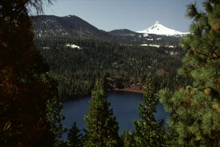 Blue Lake Crater in the foreground is one of three overlapping craters located east of Santiam Pass. The craters formed about 1,300 years ago during explosions through older volcanic bedrock; a chain of spatter cones about 6 km SSW of Blue Lake may have been active during the same eruption. The snow-covered summit of Pleistocene Mount Washington is visible in the background.
There are no samples for Washington in the Smithsonian's NMNH Department of Mineral Sciences Rock and Ore collection.
| Copernicus Browser | The Copernicus Browser replaced the Sentinel Hub Playground browser in 2023, to provide access to Earth observation archives from the Copernicus Data Space Ecosystem, the main distribution platform for data from the EU Copernicus missions. |
|
WOVOdat
Single Volcano View Temporal Evolution of Unrest Side by Side Volcanoes |
WOVOdat is a database of volcanic unrest; instrumentally and visually recorded changes in seismicity, ground deformation, gas emission, and other parameters from their normal baselines. It is sponsored by the World Organization of Volcano Observatories (WOVO) and presently hosted at the Earth Observatory of Singapore.
GVMID Data on Volcano Monitoring Infrastructure The Global Volcano Monitoring Infrastructure Database GVMID, is aimed at documenting and improving capabilities of volcano monitoring from the ground and space. GVMID should provide a snapshot and baseline view of the techniques and instrumentation that are in place at various volcanoes, which can be use by volcano observatories as reference to setup new monitoring system or improving networks at a specific volcano. These data will allow identification of what monitoring gaps exist, which can be then targeted by remote sensing infrastructure and future instrument deployments. |
| IRIS seismic stations/networks | Incorporated Research Institutions for Seismology (IRIS) Data Services map showing the location of seismic stations from all available networks (permanent or temporary) within a radius of 0.18° (about 20 km at mid-latitudes) from the given location of Washington. Users can customize a variety of filters and options in the left panel. Note that if there are no stations are known the map will default to show the entire world with a "No data matched request" error notice. |
| UNAVCO GPS/GNSS stations | Geodetic Data Services map from UNAVCO showing the location of GPS/GNSS stations from all available networks (permanent or temporary) within a radius of 20 km from the given location of Washington. Users can customize the data search based on station or network names, location, and time window. Requires Adobe Flash Player. |
| Large Eruptions of Washington | Information about large Quaternary eruptions (VEI >= 4) is cataloged in the Large Magnitude Explosive Volcanic Eruptions (LaMEVE) database of the Volcano Global Risk Identification and Analysis Project (VOGRIPA). |
| EarthChem | EarthChem develops and maintains databases, software, and services that support the preservation, discovery, access and analysis of geochemical data, and facilitate their integration with the broad array of other available earth science parameters. EarthChem is operated by a joint team of disciplinary scientists, data scientists, data managers and information technology developers who are part of the NSF-funded data facility Integrated Earth Data Applications (IEDA). IEDA is a collaborative effort of EarthChem and the Marine Geoscience Data System (MGDS). |

