
Tectonic earthquake swarm
A seismic swarm started on 17 February, with activity peaking by 20 February, and still declining as of 26 February (figure 1). More than 300 small high-frequency earthquakes (eight with M > 3.0) were recorded, the largest (M 4.0) at 0319 on 19 February. Hypocenters show a 3-km-long pattern elongated to the NNW, at 3-5 km depths (figure 2). The focal mechanism for the largest event showed mainly strike-slip motion (right-lateral on a N-S plane, or left-lateral on an E-W plane), with a small normal component. There were no reports of injuries or damages.
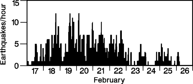 |
Figure 1. Hourly number of earthquakes in the Coso Mountains, 17-26 February 1992. Courtesy of the USGS. |
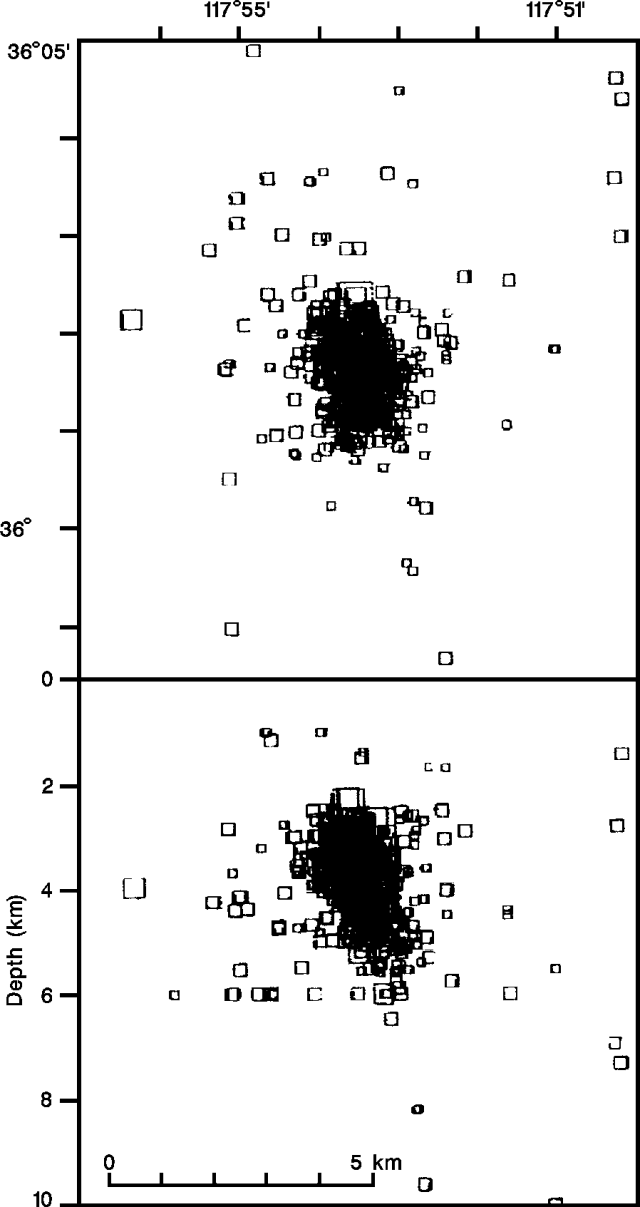 |
Figure 2. Epicenter map (top) and E-W cross-section showing focal depths (bottom) of >300 high-frequency earthquakes recorded in the Coso Mountains, 17-26 February 1992. Courtesy of the USGS. |
The Coso region is an active geothermal area that has had seismic swarms in the past, as in 1982 when thousands of events were recorded, the largest M 4.9. The Volcano Peak cinder cone and lava flow, apparently the youngest features in the Coso Mountains, are believed to have been erupted 0.039 ± 0.033 mybp. (K/Ar age).
Information Contacts: J. Mori and W. Duffield, USGS.
The Global Volcanism Program has no Weekly Reports available for Coso Volcanic Field.
Reports are organized chronologically and indexed below by Month/Year (Publication Volume:Number), and include a one-line summary. Click on the index link or scroll down to read the reports.
Tectonic earthquake swarm
A seismic swarm started on 17 February, with activity peaking by 20 February, and still declining as of 26 February (figure 1). More than 300 small high-frequency earthquakes (eight with M > 3.0) were recorded, the largest (M 4.0) at 0319 on 19 February. Hypocenters show a 3-km-long pattern elongated to the NNW, at 3-5 km depths (figure 2). The focal mechanism for the largest event showed mainly strike-slip motion (right-lateral on a N-S plane, or left-lateral on an E-W plane), with a small normal component. There were no reports of injuries or damages.
|
Figure 1. Hourly number of earthquakes in the Coso Mountains, 17-26 February 1992. Courtesy of the USGS. |
|
Figure 2. Epicenter map (top) and E-W cross-section showing focal depths (bottom) of >300 high-frequency earthquakes recorded in the Coso Mountains, 17-26 February 1992. Courtesy of the USGS. |
The Coso region is an active geothermal area that has had seismic swarms in the past, as in 1982 when thousands of events were recorded, the largest M 4.9. The Volcano Peak cinder cone and lava flow, apparently the youngest features in the Coso Mountains, are believed to have been erupted 0.039 ± 0.033 mybp. (K/Ar age).
Information Contacts: J. Mori and W. Duffield, USGS.
|
|
||||||||||||||||||||||||||
The Global Volcanism Program is not aware of any Holocene eruptions from Coso Volcanic Field. If this volcano has had large eruptions (VEI >= 4) prior to 12,000 years ago, information might be found on the Coso Volcanic Field page in the LaMEVE (Large Magnitude Explosive Volcanic Eruptions) database, a part of the Volcano Global Risk Identification and Analysis Project (VOGRIPA).
This compilation of synonyms and subsidiary features may not be comprehensive. Features are organized into four major categories: Cones, Craters, Domes, and Thermal Features. Synonyms of features appear indented below the primary name. In some cases additional feature type, elevation, or location details are provided.
Synonyms |
||||
| Coso Range | ||||
Cones |
||||
| Feature Name | Feature Type | Elevation | Latitude | Longitude |
| Volcano Butte | Cone | |||
| Volcano Peak | Cone | |||
Domes |
||||
| Feature Name | Feature Type | Elevation | Latitude | Longitude |
| Cactus Peak | Dome | |||
| Sugarloaf Mountain | Dome | |||
Thermal |
||||
| Feature Name | Feature Type | Elevation | Latitude | Longitude |
| Coso Hot Springs | Hot Spring | |||
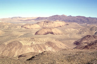 The Coso volcanic field at the western edge of the Basin and Range province consists of largely Pliocene to late-Pleistocene rhyolitic lava domes and basaltic cinder cones covering a 400 km2 area. This view looks south across the range from Cactus Peak with some of the 38 light-colored rhyolitic lava domes of the Coso volcanic field in the foreground and dark-colored basaltic cinder cones and associated lava flows in the background. Active fumaroles and thermal springs are present in an area that is a producing geothermal field.
 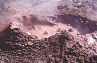 Bubbling mudpots are abundant in the Coso Hot Springs on the eastern margin of the Coso volcanic field. The hot springs occur along faults at the margins of a horst capped by rhyolitic rocks and are associated with fumaroles, mudpots, and widespread areas of hydrothermally altered ground.
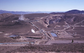 A cooperative program of the U.S. Navy China Lake Naval Weapons Station and private industry has developed geothermal power at the Coso volcanic field. The first well was drilled in 1981 and production now exceeds 250 megawatts, greatly reducing energy costs to the Navy and providing additional electricity to the southern California power grid. This view from the NW shows turbine plants and production well ponds at Coso. Devils Kitchen, a fumarolic area with extensively hydrothermally altered ground, appears at the upper right.
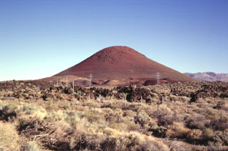 Red Cone, a basaltic cinder cone at the western margin of the Coso volcanic field, is a prominent landmark visible from Highway 395, which follows the eastern margin of the Sierra Nevada Range. The late-Pleistocene cinder cone is the largest of a group of isolated cones along the valley floor. An area of more concentrated young basaltic cones and lava flows occurs to the SE along the crest of the volcanic horst forming the Coso Range.
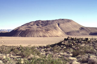 The Sugarloaf Mountain lava dome and associated lava flows, seen here from the west, is the largest of 38 rhyolitic lava domes of the Coso volcanic field, rising 300 m above its base. The high-silica rhyolite of Sugarloaf Mountain contains localized areas of obsidian that were used as a source of arrowheads for native Americans. The dome has been dated at about 41,000 ± 21,000 years and is one of the youngest volcanic vents at Coso.
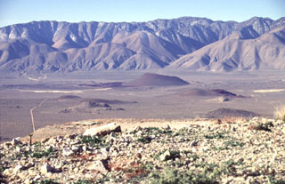 Red Cone (center) is the largest of a group of isolated basaltic scoria cones and lava flows on the floor of the Rose Valley in the western part of the Coso volcanic field. The late-Pleistocene scoria cone is seen here from the NE, with the towering fault scarp of the Sierra Nevada Range in the background. Highway 395 traverses Rose Valley between the cone and the Sierras.
 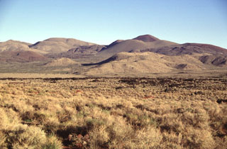 A series of basaltic cinder cones and related lava flows at the southern end of the Coso volcanic field form some of the youngest volcanic products at Coso. The cones and flows are concentrated along the south edge of a NE-trending horst that is capped by rhyolitic lava domes and flows. Many of the flows, such as the one left of center, are intracanyon flows that traveled down existing drainages.
The following 51 samples associated with this volcano can be found in the Smithsonian's NMNH Department of Mineral Sciences collections, and may be availble for research (contact the Rock and Ore Collections Manager). Catalog number links will open a window with more information.
| Catalog Number | Sample Description | Lava Source | Collection Date |
|---|---|---|---|
| NMNH 117460-100 | Rhyolite | -- | -- |
| NMNH 117460-101 | Rhyolite | -- | -- |
| NMNH 117460-102 | Rhyolite | Dome #22 | -- |
| NMNH 117460-103 | Rhyolite | -- | -- |
| NMNH 117460-104 | Obsidian | -- | -- |
| NMNH 117460-105 | Perlite | -- | -- |
| NMNH 117460-106 | Obsidian | Dome #24 | -- |
| NMNH 117460-107 | Obsidian | Dome #26 | -- |
| NMNH 117460-108 | Obsidian | Dome #27 | -- |
| NMNH 117460-109 | Rhyolite | Dome #28 | -- |
| NMNH 117460-110 | Rhyolite | Dome #29 | -- |
| NMNH 117460-111 | Rhyolite | Dome #30 | -- |
| NMNH 117460-112 | Rhyolite | Dome #31 | -- |
| NMNH 117460-113 | Rhyolite | Dome #32 | -- |
| NMNH 117460-114 | Rhyolite | Dome #33 | -- |
| NMNH 117460-115 | Rhyolite | Dome #34 | -- |
| NMNH 117460-116 | Rhyolite | Dome #35 | -- |
| NMNH 117460-117 | Rhyolite | Dome #36 | -- |
| NMNH 117460-159 | Rhyolite | Dome #1 | -- |
| NMNH 117460-160 | Rhyolite | Dome #9 | -- |
| NMNH 117460-161 | Rhyolite | Dome #11 | -- |
| NMNH 117460-162 | Rhyolite | Dome #12 | -- |
| NMNH 117460-163 | Obsidian | Dome #16 | -- |
| NMNH 117460-164 | Obsidian | Dome #17 | -- |
| NMNH 117460-165 | Rhyolite | Dome #23 | -- |
| NMNH 117460-166 | Obsidian | Dome #25 | -- |
| NMNH 117460-167 | Obsidian | Dome #38 | -- |
| NMNH 117460-168 | Rhyolite | Dome #29 | -- |
| NMNH 117460-169 | Pumice | Dome #29 | -- |
| NMNH 117460-172 | Rhyolite | Dome #2 | -- |
| NMNH 117460-173 | Rhyolite | Dome #37 | -- |
| NMNH 117460-74 | Marekanite | Olancha dome | -- |
| NMNH 117460-81 | Rhyolite | -- | -- |
| NMNH 117460-82 | Rhyolite | Dome #2 | -- |
| NMNH 117460-83 | Rhyolite | Dome #3 | -- |
| NMNH 117460-84 | Rhyolite | -- | -- |
| NMNH 117460-85 | Perlite | Dome #4 | -- |
| NMNH 117460-86 | Obsidian | Dome #5 | -- |
| NMNH 117460-87 | Obsidian | Dome #6 | -- |
| NMNH 117460-88 | Rhyolite | Dome #7 | -- |
| NMNH 117460-89 | Rhyolite | Dome #8 | -- |
| NMNH 117460-90 | Obsidian | Dome #10 | -- |
| NMNH 117460-91 | Obsidian | Dome #13 | -- |
| NMNH 117460-92 | Obsidian | Dome #14 | -- |
| NMNH 117460-93 | Obsidian | Dome #15 | -- |
| NMNH 117460-94 | Obsidian | Dome #18 | -- |
| NMNH 117460-95 | Obsidian | Dome #19 | -- |
| NMNH 117460-96 | Obsidian | Dome #20 | -- |
| NMNH 117460-97 | Obsidian | Dome #20 | -- |
| NMNH 117460-98 | Obsidian | Dome #20 | -- |
| NMNH 117460-99 | Rhyolite | Dome #21 | -- |
| Copernicus Browser | The Copernicus Browser replaced the Sentinel Hub Playground browser in 2023, to provide access to Earth observation archives from the Copernicus Data Space Ecosystem, the main distribution platform for data from the EU Copernicus missions. |
|
WOVOdat
Single Volcano View Temporal Evolution of Unrest Side by Side Volcanoes |
WOVOdat is a database of volcanic unrest; instrumentally and visually recorded changes in seismicity, ground deformation, gas emission, and other parameters from their normal baselines. It is sponsored by the World Organization of Volcano Observatories (WOVO) and presently hosted at the Earth Observatory of Singapore.
GVMID Data on Volcano Monitoring Infrastructure The Global Volcano Monitoring Infrastructure Database GVMID, is aimed at documenting and improving capabilities of volcano monitoring from the ground and space. GVMID should provide a snapshot and baseline view of the techniques and instrumentation that are in place at various volcanoes, which can be use by volcano observatories as reference to setup new monitoring system or improving networks at a specific volcano. These data will allow identification of what monitoring gaps exist, which can be then targeted by remote sensing infrastructure and future instrument deployments. |
| IRIS seismic stations/networks | Incorporated Research Institutions for Seismology (IRIS) Data Services map showing the location of seismic stations from all available networks (permanent or temporary) within a radius of 0.18° (about 20 km at mid-latitudes) from the given location of Coso Volcanic Field. Users can customize a variety of filters and options in the left panel. Note that if there are no stations are known the map will default to show the entire world with a "No data matched request" error notice. |
| UNAVCO GPS/GNSS stations | Geodetic Data Services map from UNAVCO showing the location of GPS/GNSS stations from all available networks (permanent or temporary) within a radius of 20 km from the given location of Coso Volcanic Field. Users can customize the data search based on station or network names, location, and time window. Requires Adobe Flash Player. |
| Large Eruptions of Coso Volcanic Field | Information about large Quaternary eruptions (VEI >= 4) is cataloged in the Large Magnitude Explosive Volcanic Eruptions (LaMEVE) database of the Volcano Global Risk Identification and Analysis Project (VOGRIPA). |
| EarthChem | EarthChem develops and maintains databases, software, and services that support the preservation, discovery, access and analysis of geochemical data, and facilitate their integration with the broad array of other available earth science parameters. EarthChem is operated by a joint team of disciplinary scientists, data scientists, data managers and information technology developers who are part of the NSF-funded data facility Integrated Earth Data Applications (IEDA). IEDA is a collaborative effort of EarthChem and the Marine Geoscience Data System (MGDS). |

