
T-phase data indicates possible eruption along the Blanco Fault Zone
"The NOAA Real-Time T-Phase Monitoring System recorded significant seismicity in mid-January [1994] from the East Blanco Depression of the Blanco Transform Fault Zone, ~65 km SE of the JDFR/Blanco intersection (figure 1). The event was confirmed by Navy SOSUS operators at Naval Facility Whidbey Island. The East Blanco Depression is believed to be a pull-apart basin based on extensional structures interpreted from SeaBeam bathymetry and SeaMARC-II sidescan imagery. See Embley and Wilson (1992) for additional information about the area with bathymetric and structural maps.
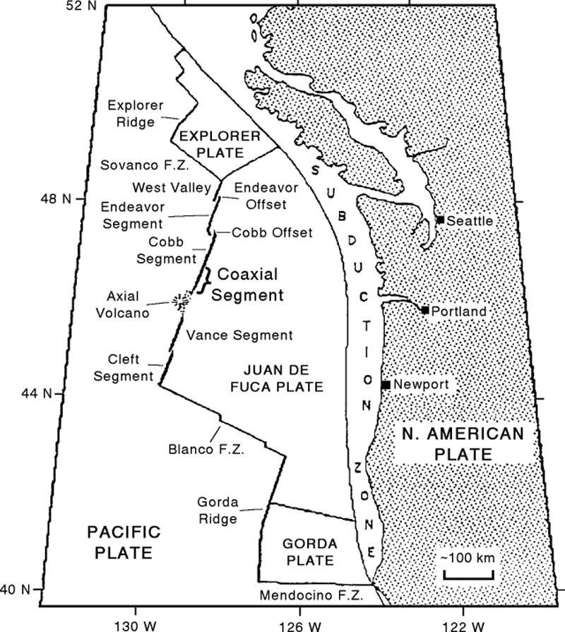 |
Figure 1. General plate tectonic map of the NE Pacific Ocean showing the North American, Pacific, Explorer, Juan de Fuca, and Gorda plates. The Coaxial Segment is just N of Axial Volcano along the Juan de Fuca Ridge. Courtesy of Bill Chadwick, NOAA. |
"The recorded T-phases [seismic phases below 1 Hz that traveled through the ocean] were very similar to those recorded from the eruption in January 1993 at Socorro Island, off the Mexican coast (18:01), and unlike earthquake swarms typically recorded from the Blanco Fracture Zone. Possible precursors (or earlier activity) were noticed as early as 10 December 1993, but intense activity began on 10 January. On some days, intermittent low-frequency tremor-like signals were very common, rising above the detection level for 3-5 minutes at intervals of 10-15 minutes; other days there were very few signals. The overall acoustic energy was considerably greater than that recorded from the Coaxial Segment last June, and the similarity to the Socorro Island event makes seafloor extrusion a real possibility. Discrete earthquakes embedded in the tremor signals allowed for time-delay calculations from three SOSUS arrays, which resulted in consistent locations near 44.2°N, 129.7°W, on the flank of the East Blanco Depression. Due to the emergent nature of the acoustic signals, the error associated with this location could be quite large (± 5 km). This intense seismo-acoustic activity from the East Blanco Depression decreased suddenly on 16 January, apparently associated with a series of relatively large earthquakes from the area, which may be related. No significant migration of activity was observed; only minor activity has been recorded since that time.
"There are currently several research cruises that may be diverted to respond to the event at some level. NOAA Ship Discoverer will be at the site 27-29 January to conduct oceanographic sampling and possibly bathymetric resurveys. RAFOS floats are available to seed hydrothermal plumes, if detected, to allow later investigation. The Univ of Washington research vessel Thomas Thompson will transit the area in Mar. The Oregon State Univ research vessel Wecoma will be in the area in April. NOAA Ship Surveyor may spend three days on-site in May. Numerous other cruises involving NOAA, Woods Hole, Univ of California (Scripps), and Navy vessels will begin in June."
Reference. Embley, R. W., and Wilson, D. S., 1992, Morphology of the Blanco Transform Fault Zone-NE Pacific: Implications for its tectonic evolution: Marine Geophysical Researches, v. 14, p. 25-45.
Further References. Dziak, R.P., Fox, C.G., Embley, R.W., Lupton, J.E., Koski, R.A., Evans, L.J., and Chadwick, W.W., 1994, Detection and response to a probable volcanogenic T-wave event swarm on the Western Blanco Transform Fault Zone (abs.): EOS v. 75, p. 717.
Information Contacts: C. Fox and W. Chadwick, NOAA Vents T-phase Project.
The Global Volcanism Program has no Weekly Reports available for East Blanco Depression.
Reports are organized chronologically and indexed below by Month/Year (Publication Volume:Number), and include a one-line summary. Click on the index link or scroll down to read the reports.
T-phase data indicates possible eruption along the Blanco Fault Zone
"The NOAA Real-Time T-Phase Monitoring System recorded significant seismicity in mid-January [1994] from the East Blanco Depression of the Blanco Transform Fault Zone, ~65 km SE of the JDFR/Blanco intersection (figure 1). The event was confirmed by Navy SOSUS operators at Naval Facility Whidbey Island. The East Blanco Depression is believed to be a pull-apart basin based on extensional structures interpreted from SeaBeam bathymetry and SeaMARC-II sidescan imagery. See Embley and Wilson (1992) for additional information about the area with bathymetric and structural maps.
|
Figure 1. General plate tectonic map of the NE Pacific Ocean showing the North American, Pacific, Explorer, Juan de Fuca, and Gorda plates. The Coaxial Segment is just N of Axial Volcano along the Juan de Fuca Ridge. Courtesy of Bill Chadwick, NOAA. |
"The recorded T-phases [seismic phases below 1 Hz that traveled through the ocean] were very similar to those recorded from the eruption in January 1993 at Socorro Island, off the Mexican coast (18:01), and unlike earthquake swarms typically recorded from the Blanco Fracture Zone. Possible precursors (or earlier activity) were noticed as early as 10 December 1993, but intense activity began on 10 January. On some days, intermittent low-frequency tremor-like signals were very common, rising above the detection level for 3-5 minutes at intervals of 10-15 minutes; other days there were very few signals. The overall acoustic energy was considerably greater than that recorded from the Coaxial Segment last June, and the similarity to the Socorro Island event makes seafloor extrusion a real possibility. Discrete earthquakes embedded in the tremor signals allowed for time-delay calculations from three SOSUS arrays, which resulted in consistent locations near 44.2°N, 129.7°W, on the flank of the East Blanco Depression. Due to the emergent nature of the acoustic signals, the error associated with this location could be quite large (± 5 km). This intense seismo-acoustic activity from the East Blanco Depression decreased suddenly on 16 January, apparently associated with a series of relatively large earthquakes from the area, which may be related. No significant migration of activity was observed; only minor activity has been recorded since that time.
"There are currently several research cruises that may be diverted to respond to the event at some level. NOAA Ship Discoverer will be at the site 27-29 January to conduct oceanographic sampling and possibly bathymetric resurveys. RAFOS floats are available to seed hydrothermal plumes, if detected, to allow later investigation. The Univ of Washington research vessel Thomas Thompson will transit the area in Mar. The Oregon State Univ research vessel Wecoma will be in the area in April. NOAA Ship Surveyor may spend three days on-site in May. Numerous other cruises involving NOAA, Woods Hole, Univ of California (Scripps), and Navy vessels will begin in June."
Reference. Embley, R. W., and Wilson, D. S., 1992, Morphology of the Blanco Transform Fault Zone-NE Pacific: Implications for its tectonic evolution: Marine Geophysical Researches, v. 14, p. 25-45.
Further References. Dziak, R.P., Fox, C.G., Embley, R.W., Lupton, J.E., Koski, R.A., Evans, L.J., and Chadwick, W.W., 1994, Detection and response to a probable volcanogenic T-wave event swarm on the Western Blanco Transform Fault Zone (abs.): EOS v. 75, p. 717.
Information Contacts: C. Fox and W. Chadwick, NOAA Vents T-phase Project.
|
|
||||||||||||||||||
The Global Volcanism Program is not aware of any Holocene eruptions from East Blanco Depression. If this volcano has had large eruptions (VEI >= 4) prior to 12,000 years ago, information might be found on the East Blanco Depression page in the LaMEVE (Large Magnitude Explosive Volcanic Eruptions) database, a part of the Volcano Global Risk Identification and Analysis Project (VOGRIPA).
The Global Volcanism Program has no synonyms or subfeatures listed for East Blanco Depression.
The Global Volcanism Program has no photographs available for East Blanco Depression.
There are no samples for East Blanco Depression in the Smithsonian's NMNH Department of Mineral Sciences Rock and Ore collection.
| Copernicus Browser | The Copernicus Browser replaced the Sentinel Hub Playground browser in 2023, to provide access to Earth observation archives from the Copernicus Data Space Ecosystem, the main distribution platform for data from the EU Copernicus missions. |
| MIROVA | Middle InfraRed Observation of Volcanic Activity (MIROVA) is a near real time volcanic hot-spot detection system based on the analysis of MODIS (Moderate Resolution Imaging Spectroradiometer) data. In particular, MIROVA uses the Middle InfraRed Radiation (MIR), measured over target volcanoes, in order to detect, locate and measure the heat radiation sourced from volcanic activity. |
| MODVOLC Thermal Alerts | Using infrared satellite Moderate Resolution Imaging Spectroradiometer (MODIS) data, scientists at the Hawai'i Institute of Geophysics and Planetology, University of Hawai'i, developed an automated system called MODVOLC to map thermal hot-spots in near real time. For each MODIS image, the algorithm automatically scans each 1 km pixel within it to check for high-temperature hot-spots. When one is found the date, time, location, and intensity are recorded. MODIS looks at every square km of the Earth every 48 hours, once during the day and once during the night, and the presence of two MODIS sensors in space allows at least four hot-spot observations every two days. Each day updated global maps are compiled to display the locations of all hot spots detected in the previous 24 hours. There is a drop-down list with volcano names which allow users to 'zoom-in' and examine the distribution of hot-spots at a variety of spatial scales. |
|
WOVOdat
Single Volcano View Temporal Evolution of Unrest Side by Side Volcanoes |
WOVOdat is a database of volcanic unrest; instrumentally and visually recorded changes in seismicity, ground deformation, gas emission, and other parameters from their normal baselines. It is sponsored by the World Organization of Volcano Observatories (WOVO) and presently hosted at the Earth Observatory of Singapore.
GVMID Data on Volcano Monitoring Infrastructure The Global Volcano Monitoring Infrastructure Database GVMID, is aimed at documenting and improving capabilities of volcano monitoring from the ground and space. GVMID should provide a snapshot and baseline view of the techniques and instrumentation that are in place at various volcanoes, which can be use by volcano observatories as reference to setup new monitoring system or improving networks at a specific volcano. These data will allow identification of what monitoring gaps exist, which can be then targeted by remote sensing infrastructure and future instrument deployments. |
| Volcanic Hazard Maps | The IAVCEI Commission on Volcanic Hazards and Risk has a Volcanic Hazard Maps database designed to serve as a resource for hazard mappers (or other interested parties) to explore how common issues in hazard map development have been addressed at different volcanoes, in different countries, for different hazards, and for different intended audiences. In addition to the comprehensive, searchable Volcanic Hazard Maps Database, this website contains information about diversity of volcanic hazard maps, illustrated using examples from the database. This site is for educational purposes related to volcanic hazard maps. Hazard maps found on this website should not be used for emergency purposes. For the most recent, official hazard map for a particular volcano, please seek out the proper institutional authorities on the matter. |
| IRIS seismic stations/networks | Incorporated Research Institutions for Seismology (IRIS) Data Services map showing the location of seismic stations from all available networks (permanent or temporary) within a radius of 0.18° (about 20 km at mid-latitudes) from the given location of East Blanco Depression. Users can customize a variety of filters and options in the left panel. Note that if there are no stations are known the map will default to show the entire world with a "No data matched request" error notice. |
| UNAVCO GPS/GNSS stations | Geodetic Data Services map from UNAVCO showing the location of GPS/GNSS stations from all available networks (permanent or temporary) within a radius of 20 km from the given location of East Blanco Depression. Users can customize the data search based on station or network names, location, and time window. Requires Adobe Flash Player. |
| DECADE Data | The DECADE portal, still in the developmental stage, serves as an example of the proposed interoperability between The Smithsonian Institution's Global Volcanism Program, the Mapping Gas Emissions (MaGa) Database, and the EarthChem Geochemical Portal. The Deep Earth Carbon Degassing (DECADE) initiative seeks to use new and established technologies to determine accurate global fluxes of volcanic CO2 to the atmosphere, but installing CO2 monitoring networks on 20 of the world's 150 most actively degassing volcanoes. The group uses related laboratory-based studies (direct gas sampling and analysis, melt inclusions) to provide new data for direct degassing of deep earth carbon to the atmosphere. |
| EarthChem | EarthChem develops and maintains databases, software, and services that support the preservation, discovery, access and analysis of geochemical data, and facilitate their integration with the broad array of other available earth science parameters. EarthChem is operated by a joint team of disciplinary scientists, data scientists, data managers and information technology developers who are part of the NSF-funded data facility Integrated Earth Data Applications (IEDA). IEDA is a collaborative effort of EarthChem and the Marine Geoscience Data System (MGDS). |

