
The Global Volcanism Program has no activity reports available for Los Azufres.
The Global Volcanism Program has no Weekly Reports available for Los Azufres.
The Global Volcanism Program has no Bulletin Reports available for Los Azufres.
|
|
||||||||||||||||||
The Global Volcanism Program is not aware of any Holocene eruptions from Los Azufres. If this volcano has had large eruptions (VEI >= 4) prior to 12,000 years ago, information might be found on the Los Azufres page in the LaMEVE (Large Magnitude Explosive Volcanic Eruptions) database, a part of the Volcano Global Risk Identification and Analysis Project (VOGRIPA).
This compilation of synonyms and subsidiary features may not be comprehensive. Features are organized into four major categories: Cones, Craters, Domes, and Thermal Features. Synonyms of features appear indented below the primary name. In some cases additional feature type, elevation, or location details are provided.
Domes |
||||
| Feature Name | Feature Type | Elevation | Latitude | Longitude |
| Chinapo, Cerro | Dome | |||
| Chino, Cerro el | Dome | |||
| Gallo, Cerro el | Dome | |||
| Guangoche, Cerro el | Dome | |||
| Humaredas, Cerro las | Dome | |||
| Jilguero, Cerro el | Dome | |||
| Mesa el Bosque | Dome | |||
| Mesa el Carpintero | Dome | |||
| Mesa el Rosario | Dome | |||
| Pizcuaro, Cerro | Dome | |||
| Providencia, Cerro la | Dome | |||
| San Andrés, Cerro de | Dome | |||
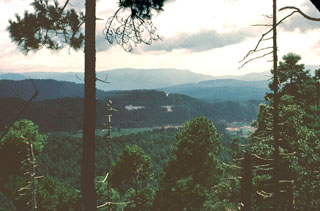 Los Azufres is one of several silicic volcanic complexes with active geothermal near the center of the Trans-Mexican Volcanic Belt. Located about 200 km NW of Mexico City, Los Azufres consists of an 18 x 20 km early Pleistocene caldera that was later partially filled by resurgent dacite to rhyolite lava domes. This view shows the Agua Fria fault and thermal features looking NE from Cerro Pizcuaro.
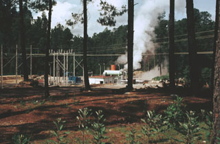 Los Azufres geothermal field began producing electricity in 1982, the year this photo was taken. The power plant at well AZ-6 shown here is located in the southern (Tejamaniles) section of the field. Surface exposures here consist of the roughly 1-million-year-old Agua Fria rhyolite rocks. Exploratory drilling began at Los Azufres in 1976, and 67 wells had been drilled by 1998 in an area of 60 km2, of which 33 were producing electricity.
The following 2 samples associated with this volcano can be found in the Smithsonian's NMNH Department of Mineral Sciences collections, and may be availble for research (contact the Rock and Ore Collections Manager). Catalog number links will open a window with more information.
| Catalog Number | Sample Description | Lava Source | Collection Date |
|---|---|---|---|
| NMNH 117450-45 | Obsidian | -- | -- |
| NMNH 117450-47 | Obsidian | -- | -- |
| Copernicus Browser | The Copernicus Browser replaced the Sentinel Hub Playground browser in 2023, to provide access to Earth observation archives from the Copernicus Data Space Ecosystem, the main distribution platform for data from the EU Copernicus missions. |
|
WOVOdat
Single Volcano View Temporal Evolution of Unrest Side by Side Volcanoes |
WOVOdat is a database of volcanic unrest; instrumentally and visually recorded changes in seismicity, ground deformation, gas emission, and other parameters from their normal baselines. It is sponsored by the World Organization of Volcano Observatories (WOVO) and presently hosted at the Earth Observatory of Singapore.
GVMID Data on Volcano Monitoring Infrastructure The Global Volcano Monitoring Infrastructure Database GVMID, is aimed at documenting and improving capabilities of volcano monitoring from the ground and space. GVMID should provide a snapshot and baseline view of the techniques and instrumentation that are in place at various volcanoes, which can be use by volcano observatories as reference to setup new monitoring system or improving networks at a specific volcano. These data will allow identification of what monitoring gaps exist, which can be then targeted by remote sensing infrastructure and future instrument deployments. |
| IRIS seismic stations/networks | Incorporated Research Institutions for Seismology (IRIS) Data Services map showing the location of seismic stations from all available networks (permanent or temporary) within a radius of 0.18° (about 20 km at mid-latitudes) from the given location of Los Azufres. Users can customize a variety of filters and options in the left panel. Note that if there are no stations are known the map will default to show the entire world with a "No data matched request" error notice. |
| UNAVCO GPS/GNSS stations | Geodetic Data Services map from UNAVCO showing the location of GPS/GNSS stations from all available networks (permanent or temporary) within a radius of 20 km from the given location of Los Azufres. Users can customize the data search based on station or network names, location, and time window. Requires Adobe Flash Player. |
| Large Eruptions of Los Azufres | Information about large Quaternary eruptions (VEI >= 4) is cataloged in the Large Magnitude Explosive Volcanic Eruptions (LaMEVE) database of the Volcano Global Risk Identification and Analysis Project (VOGRIPA). |
| EarthChem | EarthChem develops and maintains databases, software, and services that support the preservation, discovery, access and analysis of geochemical data, and facilitate their integration with the broad array of other available earth science parameters. EarthChem is operated by a joint team of disciplinary scientists, data scientists, data managers and information technology developers who are part of the NSF-funded data facility Integrated Earth Data Applications (IEDA). IEDA is a collaborative effort of EarthChem and the Marine Geoscience Data System (MGDS). |

