The Global Volcanism Program has no activity reports available for Chingo.
The Global Volcanism Program has no Weekly Reports available for Chingo.
The Global Volcanism Program has no Bulletin Reports available for Chingo.
|
|
||||||||||||||||||||||||||
The Global Volcanism Program is not aware of any Holocene eruptions from Chingo. If this volcano has had large eruptions (VEI >= 4) prior to 12,000 years ago, information might be found on the Chingo page in the LaMEVE (Large Magnitude Explosive Volcanic Eruptions) database, a part of the Volcano Global Risk Identification and Analysis Project (VOGRIPA).
This compilation of synonyms and subsidiary features may not be comprehensive. Features are organized into four major categories: Cones, Craters, Domes, and Thermal Features. Synonyms of features appear indented below the primary name. In some cases additional feature type, elevation, or location details are provided.
Cones |
||||
| Feature Name | Feature Type | Elevation | Latitude | Longitude |
| Castillo, Cerro de los | Pyroclastic cone | 862 m | 14° 9' 0.00" N | 89° 44' 0.00" W |
| Chingo, Volcán | Stratovolcano | 1775 m | 14° 7' 0.00" N | 89° 44' 0.00" W |
| Compañía, Cerro | Pyroclastic cone | 902 m | 14° 9' 0.00" N | 89° 44' 0.00" W |
| Cunistepeque, Cerro | Pyroclastic cone | 1242 m | 14° 8' 0.00" N | 89° 48' 0.00" W |
| Guacamayas, Cerro de las | Pyroclastic cone | 920 m | 14° 8' 0.00" N | 89° 44' 0.00" W |
| Malacara | Pyroclastic cone | 900 m | 14° 5' 0.00" N | 89° 42' 0.00" W |
| Olla, Cerro la | Pyroclastic cone | 932 m | 14° 4' 0.00" N | 89° 44' 0.00" W |
| Redondo, Cerro | Pyroclastic cone | 1050 m | 14° 9' 0.00" N | 89° 49' 0.00" W |
| San Bartolo, Cerro | Pyroclastic cone | 14° 14' 0.00" N | 89° 45' 0.00" W | |
| Siete Cerros, Loma Los
Chucamitepeque |
Cone | 900 m | 14° 3' 30.00" N | 89° 43' 0.00" W |
| Utal, Cerro del | Pyroclastic cone | 880 m | 14° 4' 0.00" N | 89° 42' 0.00" W |
| Viboras, Volcán las | Shield volcano | 1100 m | 14° 12' 0.00" N | 89° 44' 0.00" W |
| Yupiltepeque, Cerro de | Pyroclastic cone | 1300 m | 14° 13' 0.00" N | 89° 48' 0.00" W |
Craters |
||||
| Feature Name | Feature Type | Elevation | Latitude | Longitude |
| Depresión de San Lorenzo | Maar | 560 m | 14° 2' 0.00" N | 89° 47' 0.00" W |
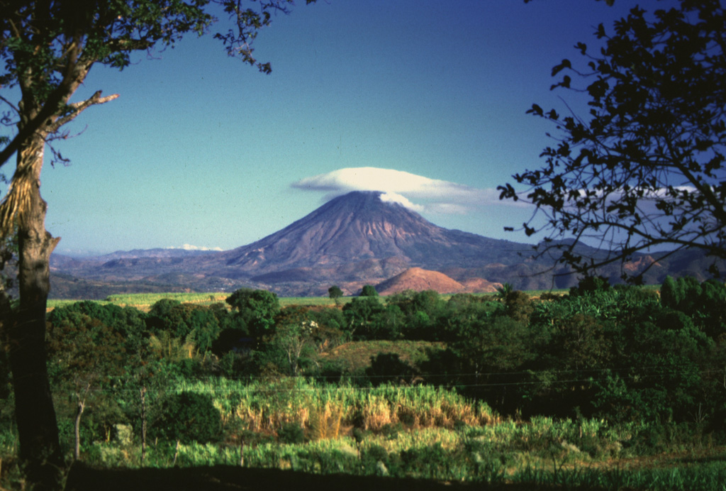
 Volcán Chingo, located along the Guatemala/El Salvador border, is the second highest of a group of volcanoes in SE Guatemala. It is seen here from the Guatemalan side above Laguna Atescatempo, which was created when lava flows from the Volcán Chingo area dammed local drainages. Many basaltic scoria cones are located on the flanks on both sides of the border.
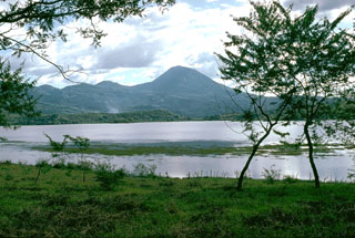
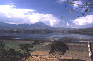 The largest peak on the El Salvador/Guatemala border is Volcán Chingo, seen here from the SW on the shores of Laguna de Llano on the Salvador side of the border.
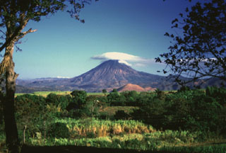 Volcán Chingo is located on the Guatemala/El Salvador border, seen here from the SE on the Salvador side of the border. The light-brown hill below is Cerro Laguneta. Other flank vents are located on the NE side and several recent lava flows are to the west and north.
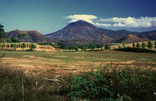 This view of Volcán Chingo from the SE side shows several smaller cones on the Salvador side of the volcano. Loma Los Siete Cerros is to the left, and the rounded cone of Cerro Laguneta to the right.
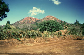 Loma Los Siete Cerros (Peak of the Seven Hills) is part of the Volcán Chingo volcanic field. This complex of overlapping scoria cones on the Salvadoran side is seen here from the east and is one of many flank vents. Among the youngest vents are those that produced lava flows on the NW side in Guatemala. Other young flows erupted from an intermittent chain of cones extending N-S on both side of the summit.
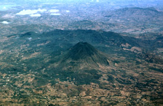 Volcán Chingo is located along the Guatemala/El Salvador border. This aerial view is from the SW, the Guatemala side. The border with El Salvador extends from the bottom-right part of the photo through Volcán Chingo to Lake Guija at the upper left corner of the photo.
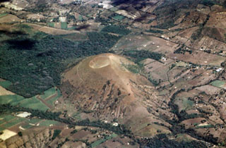 Cerro La Olla is one of a chain of young scoria cones erupted on either side of Volcán Chingo. The southern vents, including Cerro La Olla, lie in El Salvador, while the northern vents, the largest of which is Volcán Las Viboras, are in Guatemala.
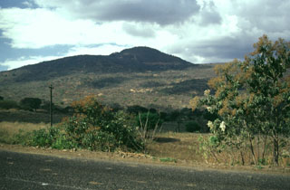 Volcán Las Viboras, north of Volcán Chingo, is a part of the Chingo volcanic field in Guatemala. Las Viboras (seen here from the north) contains a scoria cone at the summit. Recent lava flows of estimated Holocene age were erupted along this same fault on the N flank of Las Viboras and on the NW flank.
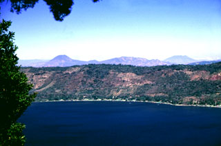 The northern wall of Coatepeque caldera rises about 250 m above the surface of Lago de Coatepeque, whose shores are lined with residences and small hotels. The peak beyond the caldera to the left is Volcán Chingo along the El Salvador/Guatemala border. The broader peak to the far right is Volcán Suchitán, one of the largest volcanoes in SE Guatemala.
 There are no samples for Chingo in the Smithsonian's NMNH Department of Mineral Sciences Rock and Ore collection.
| Copernicus Browser | The Copernicus Browser replaced the Sentinel Hub Playground browser in 2023, to provide access to Earth observation archives from the Copernicus Data Space Ecosystem, the main distribution platform for data from the EU Copernicus missions. |
| MIROVA | Middle InfraRed Observation of Volcanic Activity (MIROVA) is a near real time volcanic hot-spot detection system based on the analysis of MODIS (Moderate Resolution Imaging Spectroradiometer) data. In particular, MIROVA uses the Middle InfraRed Radiation (MIR), measured over target volcanoes, in order to detect, locate and measure the heat radiation sourced from volcanic activity. |
| MODVOLC Thermal Alerts | Using infrared satellite Moderate Resolution Imaging Spectroradiometer (MODIS) data, scientists at the Hawai'i Institute of Geophysics and Planetology, University of Hawai'i, developed an automated system called MODVOLC to map thermal hot-spots in near real time. For each MODIS image, the algorithm automatically scans each 1 km pixel within it to check for high-temperature hot-spots. When one is found the date, time, location, and intensity are recorded. MODIS looks at every square km of the Earth every 48 hours, once during the day and once during the night, and the presence of two MODIS sensors in space allows at least four hot-spot observations every two days. Each day updated global maps are compiled to display the locations of all hot spots detected in the previous 24 hours. There is a drop-down list with volcano names which allow users to 'zoom-in' and examine the distribution of hot-spots at a variety of spatial scales. |
|
WOVOdat
Single Volcano View Temporal Evolution of Unrest Side by Side Volcanoes |
WOVOdat is a database of volcanic unrest; instrumentally and visually recorded changes in seismicity, ground deformation, gas emission, and other parameters from their normal baselines. It is sponsored by the World Organization of Volcano Observatories (WOVO) and presently hosted at the Earth Observatory of Singapore.
GVMID Data on Volcano Monitoring Infrastructure The Global Volcano Monitoring Infrastructure Database GVMID, is aimed at documenting and improving capabilities of volcano monitoring from the ground and space. GVMID should provide a snapshot and baseline view of the techniques and instrumentation that are in place at various volcanoes, which can be use by volcano observatories as reference to setup new monitoring system or improving networks at a specific volcano. These data will allow identification of what monitoring gaps exist, which can be then targeted by remote sensing infrastructure and future instrument deployments. |
| Volcanic Hazard Maps | The IAVCEI Commission on Volcanic Hazards and Risk has a Volcanic Hazard Maps database designed to serve as a resource for hazard mappers (or other interested parties) to explore how common issues in hazard map development have been addressed at different volcanoes, in different countries, for different hazards, and for different intended audiences. In addition to the comprehensive, searchable Volcanic Hazard Maps Database, this website contains information about diversity of volcanic hazard maps, illustrated using examples from the database. This site is for educational purposes related to volcanic hazard maps. Hazard maps found on this website should not be used for emergency purposes. For the most recent, official hazard map for a particular volcano, please seek out the proper institutional authorities on the matter. |
| IRIS seismic stations/networks | Incorporated Research Institutions for Seismology (IRIS) Data Services map showing the location of seismic stations from all available networks (permanent or temporary) within a radius of 0.18° (about 20 km at mid-latitudes) from the given location of Chingo. Users can customize a variety of filters and options in the left panel. Note that if there are no stations are known the map will default to show the entire world with a "No data matched request" error notice. |
| UNAVCO GPS/GNSS stations | Geodetic Data Services map from UNAVCO showing the location of GPS/GNSS stations from all available networks (permanent or temporary) within a radius of 20 km from the given location of Chingo. Users can customize the data search based on station or network names, location, and time window. Requires Adobe Flash Player. |
| DECADE Data | The DECADE portal, still in the developmental stage, serves as an example of the proposed interoperability between The Smithsonian Institution's Global Volcanism Program, the Mapping Gas Emissions (MaGa) Database, and the EarthChem Geochemical Portal. The Deep Earth Carbon Degassing (DECADE) initiative seeks to use new and established technologies to determine accurate global fluxes of volcanic CO2 to the atmosphere, but installing CO2 monitoring networks on 20 of the world's 150 most actively degassing volcanoes. The group uses related laboratory-based studies (direct gas sampling and analysis, melt inclusions) to provide new data for direct degassing of deep earth carbon to the atmosphere. |
| Large Eruptions of Chingo | Information about large Quaternary eruptions (VEI >= 4) is cataloged in the Large Magnitude Explosive Volcanic Eruptions (LaMEVE) database of the Volcano Global Risk Identification and Analysis Project (VOGRIPA). |
| EarthChem | EarthChem develops and maintains databases, software, and services that support the preservation, discovery, access and analysis of geochemical data, and facilitate their integration with the broad array of other available earth science parameters. EarthChem is operated by a joint team of disciplinary scientists, data scientists, data managers and information technology developers who are part of the NSF-funded data facility Integrated Earth Data Applications (IEDA). IEDA is a collaborative effort of EarthChem and the Marine Geoscience Data System (MGDS). |

