The Global Volcanism Program has no activity reports available for Ayarza.
The Global Volcanism Program has no Weekly Reports available for Ayarza.
The Global Volcanism Program has no Bulletin Reports available for Ayarza.
|
|
||||||||||||||||||
The Global Volcanism Program is not aware of any Holocene eruptions from Ayarza. If this volcano has had large eruptions (VEI >= 4) prior to 12,000 years ago, information might be found on the Ayarza page in the LaMEVE (Large Magnitude Explosive Volcanic Eruptions) database, a part of the Volcano Global Risk Identification and Analysis Project (VOGRIPA).
The Global Volcanism Program has no synonyms or subfeatures listed for Ayarza.
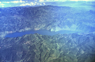 The figure-8-shaped Ayarza caldera appears elongated in this aerial oblique view from the SW. The double caldera was formed during two major rhyolitic eruptions about 27,000 and 23,100 years ago. These were among the youngest silicic eruptions in northern Central America. The larger western caldera (left) has a maximum depth of 240 m, and the eastern caldera is 140 m deep. Caldera walls rise an additional 300-600 m above the surface of Laguna de Ayarza.
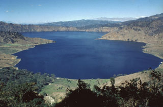 Ayarza, a scenic double caldera filled by Laguna de Ayarza, is seen here from the ESE. The peninsulas of Punta el Picacho (left) and Punta el Picachito (right) lie across an 800-m-wide channel separating the two halves of the 5 x 7 km wide, figure-8-shaped caldera. Both calderas, whose steep walls rise nearly 600 m above the lake surface, were formed within several thousand years of each other during major rhyolitic explosive eruptions in the late Pleistocene between about 27,000 and 23,100 years ago.
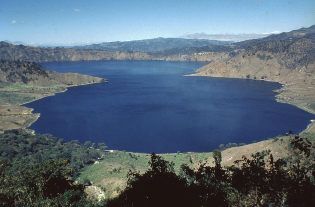
 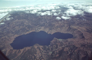 Scenic Laguna de Ayarza fills a double caldera formed during the late Pleistocene. The caldera lies about 40 km NE of the active volcanic front. The older eastern caldera (left) was associated with eruption of the Mixta pumice fall and ashflow about 27,000 years ago, and the larger western caldera was formed during eruption of the Pinos Altos airfall pumice and Tapalapa ashflows radiocarbon dated at about 23,100 years before present. Bathymetry of the lake floor shows no evidence for post-caldera eruptions.
  One of the most prominent topographic features of SE Guatemala is the figure-8-shaped double caldera of Ayarza volcano. Both calderas were formed within several thousand years of each other during major rhyolitic explosive eruptions in the late Pleistocene, about 27,000 years ago (eastern caldera) and 23,000 years ago (the larger western caldera). Formation of the older caldera was accompanied by the eruption of the chemically mixed pumices of the "Mixta" unit. The city of San Rafael las Flores, 6 km to the NE, is at the upper left.
 There are no samples for Ayarza in the Smithsonian's NMNH Department of Mineral Sciences Rock and Ore collection.
| Copernicus Browser | The Copernicus Browser replaced the Sentinel Hub Playground browser in 2023, to provide access to Earth observation archives from the Copernicus Data Space Ecosystem, the main distribution platform for data from the EU Copernicus missions. |
|
WOVOdat
Single Volcano View Temporal Evolution of Unrest Side by Side Volcanoes |
WOVOdat is a database of volcanic unrest; instrumentally and visually recorded changes in seismicity, ground deformation, gas emission, and other parameters from their normal baselines. It is sponsored by the World Organization of Volcano Observatories (WOVO) and presently hosted at the Earth Observatory of Singapore.
GVMID Data on Volcano Monitoring Infrastructure The Global Volcano Monitoring Infrastructure Database GVMID, is aimed at documenting and improving capabilities of volcano monitoring from the ground and space. GVMID should provide a snapshot and baseline view of the techniques and instrumentation that are in place at various volcanoes, which can be use by volcano observatories as reference to setup new monitoring system or improving networks at a specific volcano. These data will allow identification of what monitoring gaps exist, which can be then targeted by remote sensing infrastructure and future instrument deployments. |
| IRIS seismic stations/networks | Incorporated Research Institutions for Seismology (IRIS) Data Services map showing the location of seismic stations from all available networks (permanent or temporary) within a radius of 0.18° (about 20 km at mid-latitudes) from the given location of Ayarza. Users can customize a variety of filters and options in the left panel. Note that if there are no stations are known the map will default to show the entire world with a "No data matched request" error notice. |
| UNAVCO GPS/GNSS stations | Geodetic Data Services map from UNAVCO showing the location of GPS/GNSS stations from all available networks (permanent or temporary) within a radius of 20 km from the given location of Ayarza. Users can customize the data search based on station or network names, location, and time window. Requires Adobe Flash Player. |
| Large Eruptions of Ayarza | Information about large Quaternary eruptions (VEI >= 4) is cataloged in the Large Magnitude Explosive Volcanic Eruptions (LaMEVE) database of the Volcano Global Risk Identification and Analysis Project (VOGRIPA). |
| EarthChem | EarthChem develops and maintains databases, software, and services that support the preservation, discovery, access and analysis of geochemical data, and facilitate their integration with the broad array of other available earth science parameters. EarthChem is operated by a joint team of disciplinary scientists, data scientists, data managers and information technology developers who are part of the NSF-funded data facility Integrated Earth Data Applications (IEDA). IEDA is a collaborative effort of EarthChem and the Marine Geoscience Data System (MGDS). |

