


Submarine eruption or dike intrusion south of the Spar Fracture Zone
A submarine eruption or dike intrusion on 30 August 1999 was identified by seismic events from the Icelandic Seismological Network (SIL) at the Vedurstofa Islands. The swarm was centered ~180 km N of Grimsey and 100 km N of Kolbeinsey Island near 68.15°N, 17.75°W along the Southern Kolbeinsey Ridge south of the Spar Fracture Zone (figures 1 and 2). Although the swarm started at 0456 (UTC), most of the 143 earthquakes registered occurred between 0830 and 1100, with events continuing until after 2300 (figure 3). Seismic activity on the southern segment of Kolbeinsey Ridge had been registered since 1 July 1999.
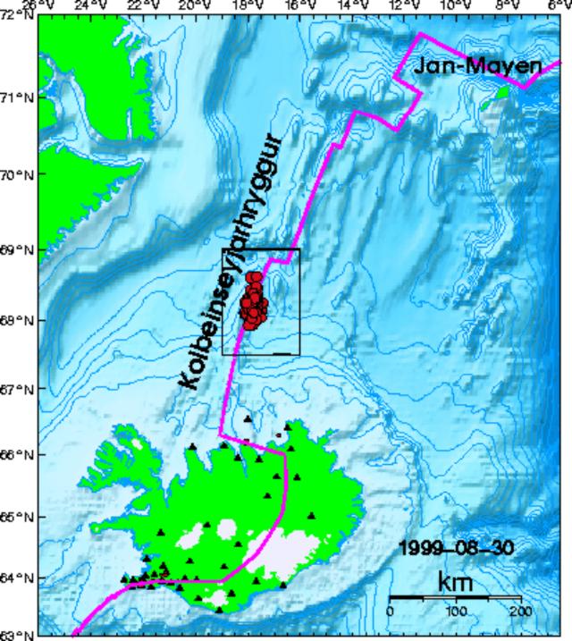 |
Figure 1. Bathymetric relief map showing Iceland, the Kolbeinsey Ridge, and the earthquake swarm of 30 August 1999. Courtesy of the Icelandic Meteorological Office. |
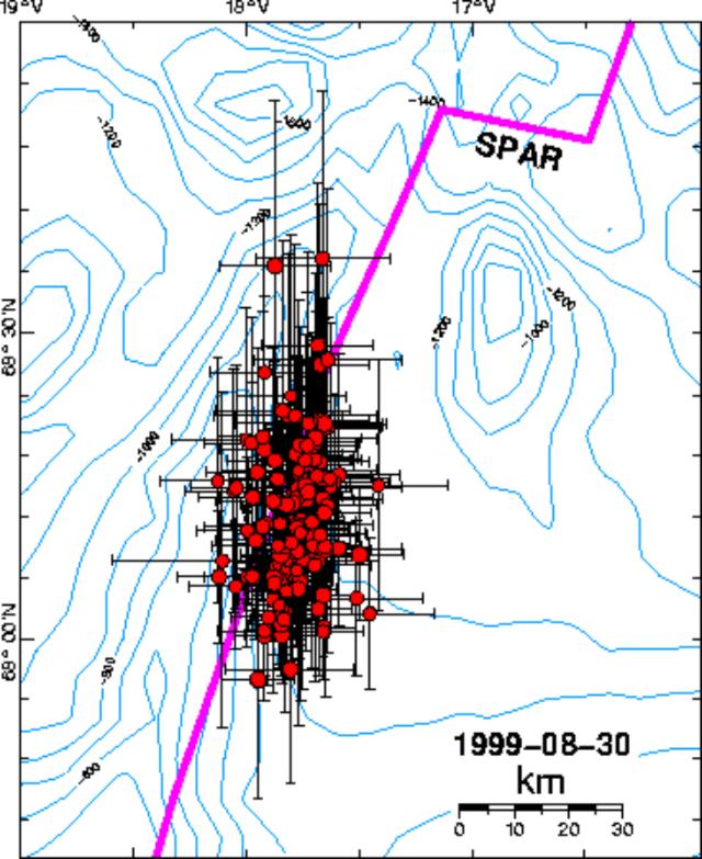 |
Figure 2. Bathymetric map showing the 30 August 1999 earthquake swarm along the Southern Kolbeinsey Ridge south of the Spar Fracture Zone. Courtesy of the Icelandic Meteorological Office. |
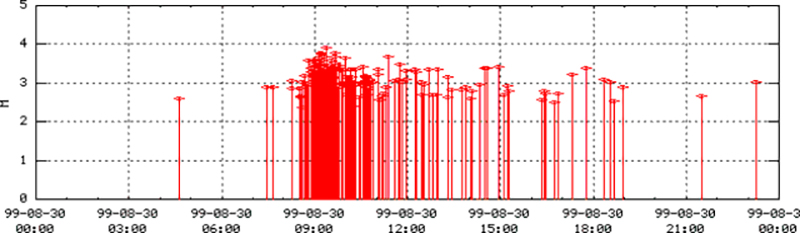 |
Figure 3. Earthquakes from the Kolbeinsey Ridge swarm on 30 August 1999 plotted by time and magnitude. Courtesy of the Icelandic Meteorological Office. |
Kolbeinsey Ridge is divided from Iceland by an oblique running transform fault, the Tjörnes Fracture Zone (TFZ). It is a slow-spreading ridge with an estimated asymmetric spreading of 10 mm/year. The ridge crest is nearly bare of sediments, although the bathymetry is very shallow. Kolbeinsey Ridge is cut by two major transform faults, the Spar Fracture Zone and the 70.8° Fracture Zone, and is thus divided into three segments, the Southern Kolbeinsey Ridge (SKR), the Northern Kolbeinsey Ridge (NKR), and the Central Kolbeinsey Ridge (CKR). The most active part of the ridge is the CKR north of the Spar Fracture Zone. Individual submarine volcanoes have not been named so far because the SIL registers events in detail only up to 300 km N of the Tjörnes Peninsula, covering just the southernmost segment of Kolbeinsey Ridge. Seismic events cluster along three lineaments in the region where the Tjörnes Fracture Zone cuts Kolbeinsey Ridge: the Grimsey lineament (east of Grimsey and N of the actual TFZ), the Husavik-Flatey fault (the actual TFZ), and the Dalvik lineament (cutting the Eyrarfjördur in half subparallel to the actual TFZ). This area is known for its hydrothermal fields made of anhydrite chimneys 200-400 m beneath sea level, which are detected along the seismic lineaments.
A submarine eruption was reported in 1372 on the Kolbeinsey Ridge NW of Grimsey Island at about 66.67°N, but the location is uncertain. Other reports of submarine eruptions N of Iceland have an even more uncertain location (1755) or have been discredited (1783 and 1838).
Further References. Kodaira, S., Mjelde, R., Gunnarsson, K., Shiobara, I., and Shimamura, H., 1997, Crustal structure of the Kolbeinsey Ridge, North Atlantic, obtained by use of ocean bottom, seismographs: JGR, v. 102, B2.
Rögnvaldsson, S.T., Gudmundsson, A., and Slunga, R., 1998, Seismotectonic analysis of the Tjörnes Fracture Zone, an active transform fault in north Iceland: JGR, v. 103, B12.
Information Contacts: Carsten Riedel, Christian-Albrechts-Universität, Kiel, Germany (URL: http://www.ifg.uni-kiel.de/); Icelandic Meteorological Office, Bustadavegur 9, 150 Reykjavík, Iceland (URL: http://www.vedur.is/).
The Global Volcanism Program has no Weekly Reports available for Kolbeinsey Ridge.
Reports are organized chronologically and indexed below by Month/Year (Publication Volume:Number), and include a one-line summary. Click on the index link or scroll down to read the reports.
Submarine eruption or dike intrusion south of the Spar Fracture Zone
A submarine eruption or dike intrusion on 30 August 1999 was identified by seismic events from the Icelandic Seismological Network (SIL) at the Vedurstofa Islands. The swarm was centered ~180 km N of Grimsey and 100 km N of Kolbeinsey Island near 68.15°N, 17.75°W along the Southern Kolbeinsey Ridge south of the Spar Fracture Zone (figures 1 and 2). Although the swarm started at 0456 (UTC), most of the 143 earthquakes registered occurred between 0830 and 1100, with events continuing until after 2300 (figure 3). Seismic activity on the southern segment of Kolbeinsey Ridge had been registered since 1 July 1999.
|
Figure 1. Bathymetric relief map showing Iceland, the Kolbeinsey Ridge, and the earthquake swarm of 30 August 1999. Courtesy of the Icelandic Meteorological Office. |
|
Figure 2. Bathymetric map showing the 30 August 1999 earthquake swarm along the Southern Kolbeinsey Ridge south of the Spar Fracture Zone. Courtesy of the Icelandic Meteorological Office. |
|
Figure 3. Earthquakes from the Kolbeinsey Ridge swarm on 30 August 1999 plotted by time and magnitude. Courtesy of the Icelandic Meteorological Office. |
Kolbeinsey Ridge is divided from Iceland by an oblique running transform fault, the Tjörnes Fracture Zone (TFZ). It is a slow-spreading ridge with an estimated asymmetric spreading of 10 mm/year. The ridge crest is nearly bare of sediments, although the bathymetry is very shallow. Kolbeinsey Ridge is cut by two major transform faults, the Spar Fracture Zone and the 70.8° Fracture Zone, and is thus divided into three segments, the Southern Kolbeinsey Ridge (SKR), the Northern Kolbeinsey Ridge (NKR), and the Central Kolbeinsey Ridge (CKR). The most active part of the ridge is the CKR north of the Spar Fracture Zone. Individual submarine volcanoes have not been named so far because the SIL registers events in detail only up to 300 km N of the Tjörnes Peninsula, covering just the southernmost segment of Kolbeinsey Ridge. Seismic events cluster along three lineaments in the region where the Tjörnes Fracture Zone cuts Kolbeinsey Ridge: the Grimsey lineament (east of Grimsey and N of the actual TFZ), the Husavik-Flatey fault (the actual TFZ), and the Dalvik lineament (cutting the Eyrarfjördur in half subparallel to the actual TFZ). This area is known for its hydrothermal fields made of anhydrite chimneys 200-400 m beneath sea level, which are detected along the seismic lineaments.
A submarine eruption was reported in 1372 on the Kolbeinsey Ridge NW of Grimsey Island at about 66.67°N, but the location is uncertain. Other reports of submarine eruptions N of Iceland have an even more uncertain location (1755) or have been discredited (1783 and 1838).
Further References. Kodaira, S., Mjelde, R., Gunnarsson, K., Shiobara, I., and Shimamura, H., 1997, Crustal structure of the Kolbeinsey Ridge, North Atlantic, obtained by use of ocean bottom, seismographs: JGR, v. 102, B2.
Rögnvaldsson, S.T., Gudmundsson, A., and Slunga, R., 1998, Seismotectonic analysis of the Tjörnes Fracture Zone, an active transform fault in north Iceland: JGR, v. 103, B12.
Information Contacts: Carsten Riedel, Christian-Albrechts-Universität, Kiel, Germany (URL: http://www.ifg.uni-kiel.de/); Icelandic Meteorological Office, Bustadavegur 9, 150 Reykjavík, Iceland (URL: http://www.vedur.is/).
|
|
||||||||||||||||||||||||||
There is data available for 2 confirmed eruptive periods.
[ 1838 Jun 11 (?) ] Discredited Eruption
[ 1783 ] Discredited Eruption
1755 Sep 18 Confirmed Eruption (Explosive / Effusive)
| Episode 1 | Eruption (Explosive / Effusive) | Volcano Uncertain: north of Iceland | ||||||||||||||||||
|---|---|---|---|---|---|---|---|---|---|---|---|---|---|---|---|---|---|---|---|
| 1755 Sep 18 - Unknown | Evidence from Unknown | ||||||||||||||||||
|
List of 2 Events for Episode 1 at Volcano Uncertain: north of Iceland
|
|||||||||||||||||||
1372 Confirmed Eruption (Explosive / Effusive) VEI: 2 (?)
| Episode 1 | Eruption (Explosive / Effusive) | NW of Grimsey Island | ||||||||||||||||||
|---|---|---|---|---|---|---|---|---|---|---|---|---|---|---|---|---|---|---|---|
| 1372 - Unknown | Evidence from Observations: Reported | ||||||||||||||||||
|
List of 2 Events for Episode 1 at NW of Grimsey Island
|
|||||||||||||||||||
The Global Volcanism Program has no synonyms or subfeatures listed for Kolbeinsey Ridge.
The Global Volcanism Program has no photographs available for Kolbeinsey Ridge.
There are no samples for Kolbeinsey Ridge in the Smithsonian's NMNH Department of Mineral Sciences Rock and Ore collection.
| Catalogue of Icelandic Volcanoes (Link to Kolbeinsey Ridge) | The Catalogue of Icelandic Volcanoes is an interactive, web-based tool, containing information on volcanic systems that belong to the active volcanic zones of Iceland. It is a collaboration of the Icelandic Meteorological Office (the state volcano observatory), the Institute of Earth Sciences at the University of Iceland, and the Civil Protection Department of the National Commissioner of the Iceland Police, with contributions from a large number of specialists in Iceland and elsewhere. This official publication is intended to serve as an accurate and up-to-date source of information about active volcanoes in Iceland and their characteristics. The Catalogue forms a part of an integrated volcanic risk assessment project in Iceland GOSVÁ (commenced in 2012), as well as being part of the effort of FUTUREVOLC (2012-2016) on establishing an Icelandic volcano supersite. |
| Copernicus Browser | The Copernicus Browser replaced the Sentinel Hub Playground browser in 2023, to provide access to Earth observation archives from the Copernicus Data Space Ecosystem, the main distribution platform for data from the EU Copernicus missions. |
| MIROVA | Middle InfraRed Observation of Volcanic Activity (MIROVA) is a near real time volcanic hot-spot detection system based on the analysis of MODIS (Moderate Resolution Imaging Spectroradiometer) data. In particular, MIROVA uses the Middle InfraRed Radiation (MIR), measured over target volcanoes, in order to detect, locate and measure the heat radiation sourced from volcanic activity. |
| MODVOLC Thermal Alerts | Using infrared satellite Moderate Resolution Imaging Spectroradiometer (MODIS) data, scientists at the Hawai'i Institute of Geophysics and Planetology, University of Hawai'i, developed an automated system called MODVOLC to map thermal hot-spots in near real time. For each MODIS image, the algorithm automatically scans each 1 km pixel within it to check for high-temperature hot-spots. When one is found the date, time, location, and intensity are recorded. MODIS looks at every square km of the Earth every 48 hours, once during the day and once during the night, and the presence of two MODIS sensors in space allows at least four hot-spot observations every two days. Each day updated global maps are compiled to display the locations of all hot spots detected in the previous 24 hours. There is a drop-down list with volcano names which allow users to 'zoom-in' and examine the distribution of hot-spots at a variety of spatial scales. |
|
WOVOdat
Single Volcano View Temporal Evolution of Unrest Side by Side Volcanoes |
WOVOdat is a database of volcanic unrest; instrumentally and visually recorded changes in seismicity, ground deformation, gas emission, and other parameters from their normal baselines. It is sponsored by the World Organization of Volcano Observatories (WOVO) and presently hosted at the Earth Observatory of Singapore.
GVMID Data on Volcano Monitoring Infrastructure The Global Volcano Monitoring Infrastructure Database GVMID, is aimed at documenting and improving capabilities of volcano monitoring from the ground and space. GVMID should provide a snapshot and baseline view of the techniques and instrumentation that are in place at various volcanoes, which can be use by volcano observatories as reference to setup new monitoring system or improving networks at a specific volcano. These data will allow identification of what monitoring gaps exist, which can be then targeted by remote sensing infrastructure and future instrument deployments. |
| Volcanic Hazard Maps | The IAVCEI Commission on Volcanic Hazards and Risk has a Volcanic Hazard Maps database designed to serve as a resource for hazard mappers (or other interested parties) to explore how common issues in hazard map development have been addressed at different volcanoes, in different countries, for different hazards, and for different intended audiences. In addition to the comprehensive, searchable Volcanic Hazard Maps Database, this website contains information about diversity of volcanic hazard maps, illustrated using examples from the database. This site is for educational purposes related to volcanic hazard maps. Hazard maps found on this website should not be used for emergency purposes. For the most recent, official hazard map for a particular volcano, please seek out the proper institutional authorities on the matter. |
| IRIS seismic stations/networks | Incorporated Research Institutions for Seismology (IRIS) Data Services map showing the location of seismic stations from all available networks (permanent or temporary) within a radius of 0.18° (about 20 km at mid-latitudes) from the given location of Kolbeinsey Ridge. Users can customize a variety of filters and options in the left panel. Note that if there are no stations are known the map will default to show the entire world with a "No data matched request" error notice. |
| UNAVCO GPS/GNSS stations | Geodetic Data Services map from UNAVCO showing the location of GPS/GNSS stations from all available networks (permanent or temporary) within a radius of 20 km from the given location of Kolbeinsey Ridge. Users can customize the data search based on station or network names, location, and time window. Requires Adobe Flash Player. |
| DECADE Data | The DECADE portal, still in the developmental stage, serves as an example of the proposed interoperability between The Smithsonian Institution's Global Volcanism Program, the Mapping Gas Emissions (MaGa) Database, and the EarthChem Geochemical Portal. The Deep Earth Carbon Degassing (DECADE) initiative seeks to use new and established technologies to determine accurate global fluxes of volcanic CO2 to the atmosphere, but installing CO2 monitoring networks on 20 of the world's 150 most actively degassing volcanoes. The group uses related laboratory-based studies (direct gas sampling and analysis, melt inclusions) to provide new data for direct degassing of deep earth carbon to the atmosphere. |
| Large Eruptions of Kolbeinsey Ridge | Information about large Quaternary eruptions (VEI >= 4) is cataloged in the Large Magnitude Explosive Volcanic Eruptions (LaMEVE) database of the Volcano Global Risk Identification and Analysis Project (VOGRIPA). |
| EarthChem | EarthChem develops and maintains databases, software, and services that support the preservation, discovery, access and analysis of geochemical data, and facilitate their integration with the broad array of other available earth science parameters. EarthChem is operated by a joint team of disciplinary scientists, data scientists, data managers and information technology developers who are part of the NSF-funded data facility Integrated Earth Data Applications (IEDA). IEDA is a collaborative effort of EarthChem and the Marine Geoscience Data System (MGDS). |