PVMBG reported that during 1 January-15 June gas plumes from Makian rose no higher than the crater rim. Seismicity fluctuated but decreased overall. On 16 June the Alert Level was lowered to 1 (on a scale of 1-4).
Source: Pusat Vulkanologi dan Mitigasi Bencana Geologi (PVMBG, also known as CVGHM)
Seismicity increased during May 2009 after tectonic earthquakes
Makian remained in repose as tectonic earthquakes striking the region preceded a cluster of volcanic earthquakes during May and early June 2009. Makian lies SW of the S-central portion of Halmahera Island (in the province of Maluku Utara). Some local residents refer to the island as Mt. Kie Besi; however, it is better known under the name of Mt. Makian (other variants include Kie Besi, Makjan, Makyan, and Wakiong).
The last eruption of Makian occurred in 1988 (SEAN 13:07, 13:08, 13:10, and 13:11) and created a volcanic dome or plug on the crater floor with a diameter of 600 m and volume of ~ 282,600 m3. The 1988 eruption led to the temporary evacuation of the island's 15,000 residents (SEAN 13:07). Not previously discussed in the Bulletin, the TOMS image archive shows several SO2 clouds from the 1988 eruption (during 30 July-5 August 1988) as well as visible and infrared imagery (Sawada, 1994).
The following information was translated from a Center of Volcanology and Geological Hazard Mitigation (CVGHM) report dated 17 July 2009. Authorities raised the hazard status on 2 June 2009 (from normal, Alert Level 1 to 2) due to the following seismic and other observations.
The pattern of earthquakes and tremor, high for most of May 2009, decreased rapidly after the 28th (table 2). Hot explosions continued until at least mid-June from sulfurous vents on the S side of the lava dome. Emissions from these vents were off-white, with weak pressure, and they fed a plume reaching ~ 10 m above the peak.
Table 2. Seismicity recorded at Makian during 1 May-3 June 2009. Courtesy of Center of Volcanology and Geological Hazard Mitigation (CVGHM).
| Date | Deep volcanic earthquakes | Shallow volcanic earthquakes | Maximum tremor amplitude |
| 01-28 May 2009 | 43 (2/day avg.) | 18 (1/day avg.) | 0.5-1 mm |
| 29-31 May 2009 | 7 (2/day avg.) | 13 (4/day avg.) | 0.5-8 mm |
| 01 June 2009 | 1 | 1 | 0.5-6 mm |
| 02-03 June 2009 | 1-10/day | 1-4/day | -- |
An increase in tectonic earthquakes in the Maluku Utara (N Moluccas) region preceded the increased activity at Makian. No recent morphological changes have been observed. Based on observations up to 30 June 2009, the hazard status was downgraded to Alert Level 1 on 16 July. However, authorities still prohibited people from climbing to the peak.
The MODVOLC system had no recorded thermal alerts from Makian from at least the beginning of 2000 through August 2009.
Reference. Sawada, Y, 1994, Tracking of Regional Volcanic Ash Clouds by Geostationary Meteorological Satellite, in Volcanic Ash and Aviation Safety: Proceedings of the First International Symposium on Volcanic Ash and Aviation Safety, edited by Thomas J. Casadevall, U.S. Geological Survey Bulletin 2047.
Information Contacts: Center of Volcanology and Geological Hazard Mitigation (CVGHM), Jalan Diponegoro 57, Bandung 40122, Indonesia (URL: http://vsi.esdm.go.id/); Hawai'i Institute of Geophysics and Planetology (HIGP) Thermal Alerts System, School of Ocean and Earth Science and Technology (SOEST), Univ. of Hawai'i, 2525 Correa Road, Honolulu, HI 96822, USA (URL: http://modis.higp.hawaii.edu/).
2016: March
| June
2009: May
| July
2001: August
PVMBG reported that during 1 January-15 June gas plumes from Makian rose no higher than the crater rim. Seismicity fluctuated but decreased overall. On 16 June the Alert Level was lowered to 1 (on a scale of 1-4).
Source: Pusat Vulkanologi dan Mitigasi Bencana Geologi (PVMBG, also known as CVGHM)
PVMBG reported that seismicity at Makian increased at the beginning of January and was characterized by deep volcanic earthquakes, low-frequency events, and tremor. Tremor amplitude increased at the beginning of March. Gas emissions did not change; weak solfatara emissions continued to rise from the crater floor. The Alert Level was raised to 3 (on a scale of 1-4) on 7 March. Residents and tourists were reminded not to approach the crater within a radius of 1.5 km.
Source: Pusat Vulkanologi dan Mitigasi Bencana Geologi (PVMBG, also known as CVGHM)
CVGHM reported that on 16 July the Alert Level for Makian was lowered from 2 to 1 (on a scale of 1-4) because no visual changes or increased seismicity were noted. Residents and tourists were not permitted to climb Makian.
Source: Pusat Vulkanologi dan Mitigasi Bencana Geologi (PVMBG, also known as CVGHM)
CVGHM reported that during 28 May-2 June seismicity from Makian increased, particularly the occurrence of tremor. Little, if any, increases in emissions were seen. The Alert level was raised to 2 (on a scale of 1-4).
Source: Pusat Vulkanologi dan Mitigasi Bencana Geologi (PVMBG, also known as CVGHM)
VSI stated that last week's report of volcanic activity at Makian on 16 August was false. An observer mistook the glow from a bush fire as volcanic activity.
Sources: Darwin Volcanic Ash Advisory Centre (VAAC); Pusat Vulkanologi dan Mitigasi Bencana Geologi (PVMBG, also known as CVGHM)
An eruption began at Makian on 16 August at 1930. During the eruption, chunks of incandescent lava were ejected 75 m through the air. Residents were evacuated to the S side of the island. The volcano is at Alert Level Red.
NOTE: VSI has since reported that this eruption is likely to have been a bush fire. We are seeking more information.
Source: Société Volcanologique Européenne
Reports are organized chronologically and indexed below by Month/Year (Publication Volume:Number), and include a one-line summary. Click on the index link or scroll down to read the reports.
Evacuation due to possible pending eruption
The Jakarta Domestic Service reported on 13 June that "the Social Affairs Dept. has designated Malifut County in Kao Subdistrict, North Maluku District, as a resettlement area for 3,250 families being evacuated from Makian Island, because there is a possibility that the volcano on the island will erupt at any time."
Information Contacts: Jakarta DRS, Jakarta.
Investigation by volcanologists reveal no signs of activity
Fears of renewed activity at Makian, which last erupted in 1890, stemmed from earthquakes felt in the area in 1972. Investigations carried out between January 1973 and July 1976 by GSI volcanologists indicated that the earthquakes recorded were of tectonic origin and that the volcano shows no signs of renewed activity.
Information Contacts: G. de Néve, GSI, Bandung.
100-year dormancy ends with large ash eruption; 15,000 evacuated; no fatalities
Makian emitted a white fume cloud 500 m above the summit crater on 17 July, ending a 100-year dormancy. Local residents reported a reddish glow at the cloud's base. The 15,000 residents of Makian Island were evacuated to Moti Island, 10 km N, in anticipation of a larger event similar to past violent eruptions. A NOTAM issued on 18 July at 1156 warned aircraft to avoid the area below ~2 km altitude. By 28 July, activity was limited to emission of a white fume cloud. On 29 July at 1115, a 7-km ash column was erupted, and at 1121, a larger explosion ejected an 8-km cloud. VSI monitored the eruption from its observation post on Moti Island. Smaller explosions occurred that afternoon and were continuing as of 1 August.
GMS satellite imagery first showed an eruption plume on 29 July [at] 1200, when a cloud 55 km wide and 100 km long extended SW from Makian (figure 1). Its coldest area was from -68 to -75°C, corresponding to an altitude of 14-16 km asl (figure 2). Plumes were not evident at 1800 or 2100. Small volcanic-like clouds, ~30 km wide and 130 km long, were seen from Makian to the WSW at 2100 on 30 July and 0300, 0900, 1200 on 31 July. Other small clouds seen 1-4 August may be atmospheric.
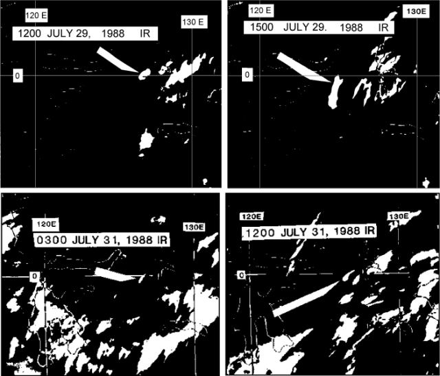 |
Figure 1. Portions of four infrared GMS satellite images on 29 and 31 July 1988, showing clouds that may have been erupted from Makian. Arrows indicate the clouds, apparently attached to the volcano at 1200 on 29 July and at 1200 on 31 July. Courtesy of Y. Sawada. |
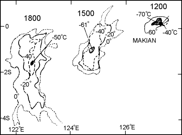 |
Figure 2. Temperature gradients in Makian's 29 July 1988 eruption cloud, measured from three GMS infrared images. The volcano is indicated by a solid triangle. Courtesy of Y. Sawada. |
Information Contacts: VSI; J. Latter, DSIR Geophysics, New Zealand; Y. Sawada, JMA.
Weak steam emission and seismicity
Smaller explosions continued until early August, then activity steadily decreased. Weak emissions of white steam reached more than 100 m above the crater rim during August. About 17 volcanic and seven tectonic earthquakes were registered daily.
Information Contacts: VSI.
Satellite data on July plumes
New data from Japan's GMS satellite.... An image at 1200 on 29 July (figure 1) shows a dense plume with a surface temperature of -70°C (figure 2), suggesting an altitude of 15.2 km (table 1).
Table 1. Analysis of GMS satellite data by Yosihiro Sawada, with parameters of the 29 July Makian plume and possible eruption clouds on 31 July 1988.
| Date | Local time | Attached to volcano? | Width (km) | Length (km) | Direction | Surface Temp. | Height (km) |
| 29 Jul 1988 | 1200 | yes | 60 | 110 | SW | -70°C | 15.2 |
| 29 Jul 1988 | 1500 | no | 90 | 310 | SW-W | -61°C | 13.5 |
| 29 Jul 1988 | 1800 | no | 80 | 430 | SW-W | -50°C | 12.1 |
| 29 Jul 1988 | 2100 | no | 90 | 450 | SW-W | -- | -- |
| 31 Jul 1988 | 0300 | no | 30 | 130 | SW-W | -49°C | 11.9 |
| 31 Jul 1988 | 0600 | no | 20 | 60 | SW | -20°C | 7.6 |
| 31 Jul 1988 | 0900 | yes | 50 | 210 | SW | -14°C | 6.8 |
| 31 Jul 1988 | 1200 | yes | 40 | 130 | W-SW | -73°C | 15.6 |
By the time of the next image, three hours later, the plume was detached from the volcano and was noticeably more diffuse. Possible volcanic plumes were also detected on GMS imagery returned 31 July (figures 1 and 3), but no ground reports of large eruption clouds are known at those times.
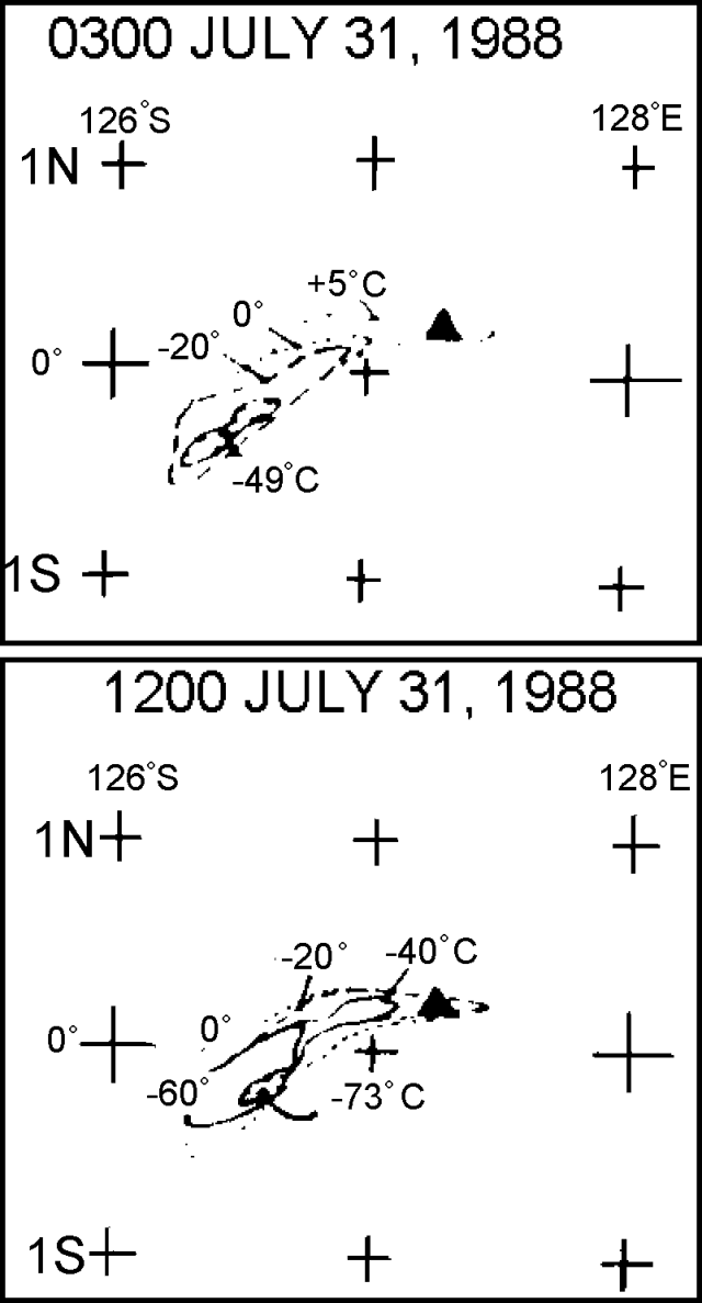 |
Figure 3. Temperature gradients in the clouds shown in figure 1. Makian is marked by a solid triangle. Courtesy of Y. Sawada. |
Information Contacts: Y. Sawada, JMA.
More details on July-August eruption
. . . . The number of shallow volcanic earthquakes began to increase sharply on 20 July. Based on seismic and visual data, VSI anticipated that an eruption would begin within two weeks, and the 15,000 residents of Makian Island were evacuated to Moti Island, ~6 km to the N.
On 28 July, 521 seismic events were recorded, and tremor began . . . at 2200. The eruption started the next morning at 1112 with a continuous thunderous explosion that was clearly heard on Moti Island. A dark ash cloud reached 8-10 km height. On 30 July at 1006, an explosion was followed by nuées ardentes that advanced E (along the Ng. Powate valley) and N (Ng. Para valley). Originating from ~1,200 m asl, the nuées ardentes descended to 250 m altitude, and some finally reached the sea. A series of smaller explosions began on 31 July and continued until 6 August, feeding ash columns that decreased from 6 to 1-2 km above the crater.
As of the first week in December, white fume was still rising weakly from the crater. Seismicity continued to decrease, with 17 tectonic and 14 volcanic earthquakes recorded 1-7 December.
Information Contacts: VSI.
Brush fire leads to a falsely alleged 16-17 August 2001 eruption report
Makian was falsely alleged to have begun erupting at 1930 on 16 August 2001. The same Jakarta news article also reported that the volcano continued to spew lava on 17 August forcing residents to evacuate. The article also noted that hot ash and debris were ejected to a height of 20 m and dark clouds rose 75 m.
The Volcanological Survey of Indonesia (VSI) later indicated that the report was false. An observer had mistakenly interpreted the glow from a brush fire as volcanic activity. VSI has not reported any recent volcanic activity at Makian.
Information Contacts: Dali Ahmad, Volcanological Survey of Indonesia (VSI), Jalan Diponegoro No. 57, Bandung 40122, Indonesia (URL: http://www.vsi.esdm.go.id/).; Darwin VAAC, Bureau of Meteorology, Northern Territory Regional Office, PO Box 40050, Casuarina, Northern Territory 0811, Australia; Meteorological and Geophysical Agency of Indonesia (Badan Meteorologi dan Geofisika, BMG), Jalan Angkasa I/2 Kemayoran, Jakarta Pusat 10720, Indonesia (URL: http://www.bmg.go.id/), Société Volcanologique Européenne.
Seismicity increased during May 2009 after tectonic earthquakes
Makian remained in repose as tectonic earthquakes striking the region preceded a cluster of volcanic earthquakes during May and early June 2009. Makian lies SW of the S-central portion of Halmahera Island (in the province of Maluku Utara). Some local residents refer to the island as Mt. Kie Besi; however, it is better known under the name of Mt. Makian (other variants include Kie Besi, Makjan, Makyan, and Wakiong).
The last eruption of Makian occurred in 1988 (SEAN 13:07, 13:08, 13:10, and 13:11) and created a volcanic dome or plug on the crater floor with a diameter of 600 m and volume of ~ 282,600 m3. The 1988 eruption led to the temporary evacuation of the island's 15,000 residents (SEAN 13:07). Not previously discussed in the Bulletin, the TOMS image archive shows several SO2 clouds from the 1988 eruption (during 30 July-5 August 1988) as well as visible and infrared imagery (Sawada, 1994).
The following information was translated from a Center of Volcanology and Geological Hazard Mitigation (CVGHM) report dated 17 July 2009. Authorities raised the hazard status on 2 June 2009 (from normal, Alert Level 1 to 2) due to the following seismic and other observations.
The pattern of earthquakes and tremor, high for most of May 2009, decreased rapidly after the 28th (table 2). Hot explosions continued until at least mid-June from sulfurous vents on the S side of the lava dome. Emissions from these vents were off-white, with weak pressure, and they fed a plume reaching ~ 10 m above the peak.
Table 2. Seismicity recorded at Makian during 1 May-3 June 2009. Courtesy of Center of Volcanology and Geological Hazard Mitigation (CVGHM).
| Date | Deep volcanic earthquakes | Shallow volcanic earthquakes | Maximum tremor amplitude |
| 01-28 May 2009 | 43 (2/day avg.) | 18 (1/day avg.) | 0.5-1 mm |
| 29-31 May 2009 | 7 (2/day avg.) | 13 (4/day avg.) | 0.5-8 mm |
| 01 June 2009 | 1 | 1 | 0.5-6 mm |
| 02-03 June 2009 | 1-10/day | 1-4/day | -- |
An increase in tectonic earthquakes in the Maluku Utara (N Moluccas) region preceded the increased activity at Makian. No recent morphological changes have been observed. Based on observations up to 30 June 2009, the hazard status was downgraded to Alert Level 1 on 16 July. However, authorities still prohibited people from climbing to the peak.
The MODVOLC system had no recorded thermal alerts from Makian from at least the beginning of 2000 through August 2009.
Reference. Sawada, Y, 1994, Tracking of Regional Volcanic Ash Clouds by Geostationary Meteorological Satellite, in Volcanic Ash and Aviation Safety: Proceedings of the First International Symposium on Volcanic Ash and Aviation Safety, edited by Thomas J. Casadevall, U.S. Geological Survey Bulletin 2047.
Information Contacts: Center of Volcanology and Geological Hazard Mitigation (CVGHM), Jalan Diponegoro 57, Bandung 40122, Indonesia (URL: http://vsi.esdm.go.id/); Hawai'i Institute of Geophysics and Planetology (HIGP) Thermal Alerts System, School of Ocean and Earth Science and Technology (SOEST), Univ. of Hawai'i, 2525 Correa Road, Honolulu, HI 96822, USA (URL: http://modis.higp.hawaii.edu/).
This compilation of synonyms and subsidiary features may not be comprehensive. Features are organized into four major categories: Cones, Craters, Domes, and Thermal Features. Synonyms of features appear indented below the primary name. In some cases additional feature type, elevation, or location details are provided.
Synonyms |
| Wakiong | Makjan | Makyan | Makian |
|
|
||||||||||||||||||||||||
There is data available for 8 confirmed Holocene eruptive periods.
1988 Jul 29 - 1988 Aug 5 Confirmed Eruption Max VEI: 3
| Episode 1 | Eruption Episode | |||||||||||||||||||||||||||||||||||||||||||||||||||||||||||||||||
|---|---|---|---|---|---|---|---|---|---|---|---|---|---|---|---|---|---|---|---|---|---|---|---|---|---|---|---|---|---|---|---|---|---|---|---|---|---|---|---|---|---|---|---|---|---|---|---|---|---|---|---|---|---|---|---|---|---|---|---|---|---|---|---|---|---|
| 1988 Jul 29 - 1988 Aug 5 | Evidence from Observations: Reported | ||||||||||||||||||||||||||||||||||||||||||||||||||||||||||||||||
|
List of 11 Events for Episode 1
| |||||||||||||||||||||||||||||||||||||||||||||||||||||||||||||||||
1890 Jun 20 - 1890 Jun 30 Confirmed Eruption Max VEI: 2
| Episode 1 | Eruption Episode | |||||||||||||||||||||||||||||||||||||||||||||||||||||||||||||||||
|---|---|---|---|---|---|---|---|---|---|---|---|---|---|---|---|---|---|---|---|---|---|---|---|---|---|---|---|---|---|---|---|---|---|---|---|---|---|---|---|---|---|---|---|---|---|---|---|---|---|---|---|---|---|---|---|---|---|---|---|---|---|---|---|---|---|
| 1890 Jun 20 - 1890 Jun 30 | Evidence from Observations: Reported | ||||||||||||||||||||||||||||||||||||||||||||||||||||||||||||||||
|
List of 11 Events for Episode 1
| |||||||||||||||||||||||||||||||||||||||||||||||||||||||||||||||||
1864 Oct - 1864 Oct Confirmed Eruption Max VEI: 1
| Episode 1 | Eruption Episode | |||||||||||||||||||||||||
|---|---|---|---|---|---|---|---|---|---|---|---|---|---|---|---|---|---|---|---|---|---|---|---|---|---|
| 1864 Oct - 1864 Oct | Evidence from Observations: Reported | ||||||||||||||||||||||||
|
List of 3 Events for Episode 1
| |||||||||||||||||||||||||
1863 Aug 25 - 1863 Aug 31 Confirmed Eruption Max VEI: 1
| Episode 1 | Eruption Episode | |||||||||||||||||||||||||
|---|---|---|---|---|---|---|---|---|---|---|---|---|---|---|---|---|---|---|---|---|---|---|---|---|---|
| 1863 Aug 25 - 1863 Aug 31 | Evidence from Observations: Reported | ||||||||||||||||||||||||
|
List of 3 Events for Episode 1
| |||||||||||||||||||||||||
1861 Dec 28 - 1862 Oct Confirmed Eruption Max VEI: 4 (?)
| Episode 1 | Eruption Episode | |||||||||||||||||||||||||||||||||||||||||||||||||||||||||||||||||||||||||||
|---|---|---|---|---|---|---|---|---|---|---|---|---|---|---|---|---|---|---|---|---|---|---|---|---|---|---|---|---|---|---|---|---|---|---|---|---|---|---|---|---|---|---|---|---|---|---|---|---|---|---|---|---|---|---|---|---|---|---|---|---|---|---|---|---|---|---|---|---|---|---|---|---|---|---|---|
| 1861 Dec 28 - 1862 Oct | Evidence from Observations: Reported | ||||||||||||||||||||||||||||||||||||||||||||||||||||||||||||||||||||||||||
|
List of 13 Events for Episode 1
| |||||||||||||||||||||||||||||||||||||||||||||||||||||||||||||||||||||||||||
[ 1860 ] Uncertain Eruption
| Episode 1 | Eruption Episode | |||||||||||||||||||||||||
|---|---|---|---|---|---|---|---|---|---|---|---|---|---|---|---|---|---|---|---|---|---|---|---|---|---|
| 1860 - Unknown | Evidence from Unknown | ||||||||||||||||||||||||
|
List of 3 Events for Episode 1
| |||||||||||||||||||||||||
[ 1854 Jun 18 - 1854 Jun 18 ] Uncertain Eruption
| Episode 1 | Eruption Episode | ||||||||||||||||||||
|---|---|---|---|---|---|---|---|---|---|---|---|---|---|---|---|---|---|---|---|---|
| 1854 Jun 18 - 1854 Jun 18 | Evidence from Unknown | |||||||||||||||||||
|
List of 2 Events for Episode 1
| ||||||||||||||||||||
1760 Sep 22 - 1761 Apr 30 (in or after) Confirmed Eruption Max VEI: 4 (?)
| Episode 1 | Eruption Episode | |||||||||||||||||||||||||||||||||||||||||||||
|---|---|---|---|---|---|---|---|---|---|---|---|---|---|---|---|---|---|---|---|---|---|---|---|---|---|---|---|---|---|---|---|---|---|---|---|---|---|---|---|---|---|---|---|---|---|
| 1760 Sep 22 - 1761 Apr 30 (in or after) | Evidence from Observations: Reported | ||||||||||||||||||||||||||||||||||||||||||||
|
List of 7 Events for Episode 1
| |||||||||||||||||||||||||||||||||||||||||||||
[ 1660 ] Uncertain Eruption
| Episode 1 | Eruption Episode | ||||
|---|---|---|---|---|
| 1660 - Unknown | Evidence from Unknown | |||
1646 Jul 19 - 1646 Jul 21 Confirmed Eruption Max VEI: 4 (?)
| Episode 1 | Eruption Episode | |||||||||||||||||||||||||||||||||||||||||||||||||||||||
|---|---|---|---|---|---|---|---|---|---|---|---|---|---|---|---|---|---|---|---|---|---|---|---|---|---|---|---|---|---|---|---|---|---|---|---|---|---|---|---|---|---|---|---|---|---|---|---|---|---|---|---|---|---|---|---|
| 1646 Jul 19 - 1646 Jul 21 | Evidence from Observations: Reported | ||||||||||||||||||||||||||||||||||||||||||||||||||||||
|
List of 9 Events for Episode 1
| |||||||||||||||||||||||||||||||||||||||||||||||||||||||
[ 1608 - 1609 ] Discredited Eruption
1550 (in or before) Confirmed Eruption Max VEI: 3
| Episode 1 | Eruption Episode | ||||||||||||||||||||||||||||||||||||||||
|---|---|---|---|---|---|---|---|---|---|---|---|---|---|---|---|---|---|---|---|---|---|---|---|---|---|---|---|---|---|---|---|---|---|---|---|---|---|---|---|---|
| 1550 (in or before) - Unknown | Evidence from Observations: Reported | |||||||||||||||||||||||||||||||||||||||
|
List of 6 Events for Episode 1
| ||||||||||||||||||||||||||||||||||||||||
There is no Deformation History data available for Kie Besi.
There is data available for 1 emission periods. Expand each entry for additional details.
| Start Date: 1988 Jul 29 | Stop Date: 1988 Jul 29 | Method: Satellite (Nimbus-7 TOMS) |
| SO2 Altitude Min: 16 km | SO2 Altitude Max: 16 km | Total SO2 Mass: 50 kt |
Data Details
| Date Start | Date End | Assumed SO2 Altitude | SO2 Algorithm | SO2 Mass |
| 19880729 | 16.0 | 50.000 |
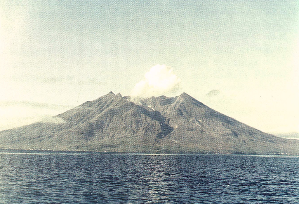
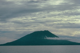 Makian volcano, one of a chain of islands off the western coast of Halmahera Island, has been the source of infrequent, but violent eruptions that have devastated villages on the 10-km-wide island. The 1357-m summit is truncated by a 1.5-km-wide crater containing a small crater lake on the NE side. Two large valleys, on the east and north sides, drain to the coast. Four flank cones occur on the west side.
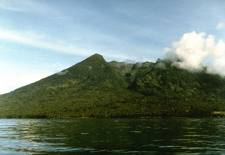 Makian volcano, one of a chain of islands off the western coast of Halmahera Island, has been the source of infrequent, but violent eruptions that have devastated villages on the 10-km-wide island. The large summit crater containing a small crater lake on the NE side is drained by two steep-walled valleys. The northern valley, Barranco Ngopagita is seen in this view from the NW.
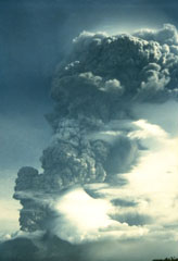 A vigorous eruption column rises above Makian volcano in this 1988 view from neighboring Moti Island. The six-day eruption began on July 29, producing eruption columns that reached 8-10 km altitude. Pyroclastic flows on the 30th reached the coast of the island, whose 15,000 residents had been evacuated. A flat-topped lava dome was extruded in the summit crater at the conclusion of the eruption.
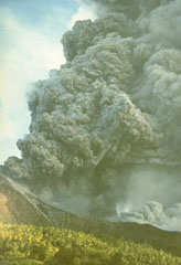 An ash plume rises above Indonesia's Makian volcano in this photo taken on 31 July 1988 from the neighboring Moti Island. The six-day eruption began on 29 July and produced ash plumes that reached 8-10 km altitude. Pyroclastic flows on the 30th reached the coast of the island where 15,000 residents had been evacuated. A lava dome was extruded in the summit crater at the end of the eruption.
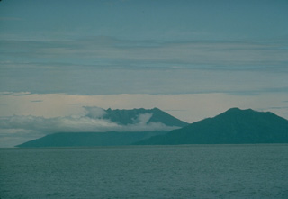 Two volcanoes of the North Maluku islands rise above the sea surface to the SW across the strait west of Halmahera Island. On the right is the 5-km-wide island of Moti, also known as Motir. The truncated, conical island is surrounded by coral reefs, and contains a crater on its SSW side. There are no confirmed historical eruptions from Moti, but flat-topped Makian volcano (left) has been the source of several powerful eruptions since the 16th century that have devastated the 10-km-wide island.
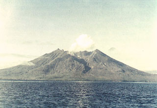 Makian volcano forms a 10-km-wide island near the southern end of a chain of volcanic islands off the western coast of Halmahera. The northern of two prominent valleys that extend from the summit is prominent in this photo. The large 1.5-km-wide summit crater containing a small lake on the NE side gives the 1357-m-high peak a flat-topped profile. Violent eruptions from Makian volcano, also known as Kie Besi, have devastated villages on the island.
The Global Volcanism Program has no maps available for Kie Besi.
There are no samples for Kie Besi in the Smithsonian's NMNH Department of Mineral Sciences Rock and Ore collection.
| Copernicus Browser | The Copernicus Browser replaced the Sentinel Hub Playground browser in 2023, to provide access to Earth observation archives from the Copernicus Data Space Ecosystem, the main distribution platform for data from the EU Copernicus missions. |
| MIROVA | Middle InfraRed Observation of Volcanic Activity (MIROVA) is a near real time volcanic hot-spot detection system based on the analysis of MODIS (Moderate Resolution Imaging Spectroradiometer) data. In particular, MIROVA uses the Middle InfraRed Radiation (MIR), measured over target volcanoes, in order to detect, locate and measure the heat radiation sourced from volcanic activity. |
| MODVOLC Thermal Alerts | Using infrared satellite Moderate Resolution Imaging Spectroradiometer (MODIS) data, scientists at the Hawai'i Institute of Geophysics and Planetology, University of Hawai'i, developed an automated system called MODVOLC to map thermal hot-spots in near real time. For each MODIS image, the algorithm automatically scans each 1 km pixel within it to check for high-temperature hot-spots. When one is found the date, time, location, and intensity are recorded. MODIS looks at every square km of the Earth every 48 hours, once during the day and once during the night, and the presence of two MODIS sensors in space allows at least four hot-spot observations every two days. Each day updated global maps are compiled to display the locations of all hot spots detected in the previous 24 hours. There is a drop-down list with volcano names which allow users to 'zoom-in' and examine the distribution of hot-spots at a variety of spatial scales. |
|
WOVOdat
Single Volcano View Temporal Evolution of Unrest Side by Side Volcanoes |
WOVOdat is a database of volcanic unrest; instrumentally and visually recorded changes in seismicity, ground deformation, gas emission, and other parameters from their normal baselines. It is sponsored by the World Organization of Volcano Observatories (WOVO) and presently hosted at the Earth Observatory of Singapore.
GVMID Data on Volcano Monitoring Infrastructure The Global Volcano Monitoring Infrastructure Database GVMID, is aimed at documenting and improving capabilities of volcano monitoring from the ground and space. GVMID should provide a snapshot and baseline view of the techniques and instrumentation that are in place at various volcanoes, which can be use by volcano observatories as reference to setup new monitoring system or improving networks at a specific volcano. These data will allow identification of what monitoring gaps exist, which can be then targeted by remote sensing infrastructure and future instrument deployments. |
| Volcanic Hazard Maps | The IAVCEI Commission on Volcanic Hazards and Risk has a Volcanic Hazard Maps database designed to serve as a resource for hazard mappers (or other interested parties) to explore how common issues in hazard map development have been addressed at different volcanoes, in different countries, for different hazards, and for different intended audiences. In addition to the comprehensive, searchable Volcanic Hazard Maps Database, this website contains information about diversity of volcanic hazard maps, illustrated using examples from the database. This site is for educational purposes related to volcanic hazard maps. Hazard maps found on this website should not be used for emergency purposes. For the most recent, official hazard map for a particular volcano, please seek out the proper institutional authorities on the matter. |
| IRIS seismic stations/networks | Incorporated Research Institutions for Seismology (IRIS) Data Services map showing the location of seismic stations from all available networks (permanent or temporary) within a radius of 0.18° (about 20 km at mid-latitudes) from the given location of Kie Besi. Users can customize a variety of filters and options in the left panel. Note that if there are no stations are known the map will default to show the entire world with a "No data matched request" error notice. |
| UNAVCO GPS/GNSS stations | Geodetic Data Services map from UNAVCO showing the location of GPS/GNSS stations from all available networks (permanent or temporary) within a radius of 20 km from the given location of Kie Besi. Users can customize the data search based on station or network names, location, and time window. Requires Adobe Flash Player. |
| DECADE Data | The DECADE portal, still in the developmental stage, serves as an example of the proposed interoperability between The Smithsonian Institution's Global Volcanism Program, the Mapping Gas Emissions (MaGa) Database, and the EarthChem Geochemical Portal. The Deep Earth Carbon Degassing (DECADE) initiative seeks to use new and established technologies to determine accurate global fluxes of volcanic CO2 to the atmosphere, but installing CO2 monitoring networks on 20 of the world's 150 most actively degassing volcanoes. The group uses related laboratory-based studies (direct gas sampling and analysis, melt inclusions) to provide new data for direct degassing of deep earth carbon to the atmosphere. |
| Large Eruptions of Kie Besi | Information about large Quaternary eruptions (VEI >= 4) is cataloged in the Large Magnitude Explosive Volcanic Eruptions (LaMEVE) database of the Volcano Global Risk Identification and Analysis Project (VOGRIPA). |
| EarthChem | EarthChem develops and maintains databases, software, and services that support the preservation, discovery, access and analysis of geochemical data, and facilitate their integration with the broad array of other available earth science parameters. EarthChem is operated by a joint team of disciplinary scientists, data scientists, data managers and information technology developers who are part of the NSF-funded data facility Integrated Earth Data Applications (IEDA). IEDA is a collaborative effort of EarthChem and the Marine Geoscience Data System (MGDS). |

