Report on Bamus (Papua New Guinea) — March 1990

Bulletin of the Global Volcanism Network, vol. 15, no. 3 (March 1990)
Managing Editor: Lindsay McClelland.
Bamus (Papua New Guinea) Strong earthquake swarm, then somewhat decreased seismicity
Please cite this report as:
Global Volcanism Program, 1990. Report on Bamus (Papua New Guinea) (McClelland, L., ed.). Bulletin of the Global Volcanism Network, 15:3. Smithsonian Institution. https://doi.org/10.5479/si.GVP.BGVN199003-252110
Bamus
Papua New Guinea
5.2°S, 151.23°E; summit elev. 2248 m
All times are local (unless otherwise noted)
"Seismicity. . . continued throughout March, although at a milder level after the 5th. Following intense February seismicity that involved 83 earthquakes of ML >=4.0, eight of ML >=5.0, and one of ML >=6.0, activity was strong again 3-5 March. More than 720 earthquakes (two of ML = 5.0-5.1 and 10 of ML >=4.5) were recorded before seismicity decreased to 20-50 events/day of small-moderate magnitude. The energy released by the February-March seismicity was relatively large, 1.22 x 10²¹ ergs (figure 1).
 |
Figure 1. Daily number of earthquakes (bars) and cumulative energy release (circles) near Bamus, February-March 1990. Magnitudes (ML) of larger events are given over earthquake count bars. Courtesy of RVO. |
"An inspection of the Bamus area was carried out on 6 March. Rockfalls had occurred at many places on the volcano and in the limestone ranges to the S. However, no change was observed in the temperatures of the solfataric areas on the summit tholoid (which remained at <=15°C).
"Temporary seismograph networks were operated in the area 13-16 February and 6-8 March. Earthquake locations defined a broad 15-km-long seismic zone trending NNE that extended from the Nakanai Mountains to the S flank of Bamus (figure 2). Within this zone was a concentration of locations trending ENE near the S foot of Bamus. Earthquake focal depths ranged from 0 to 23 km.
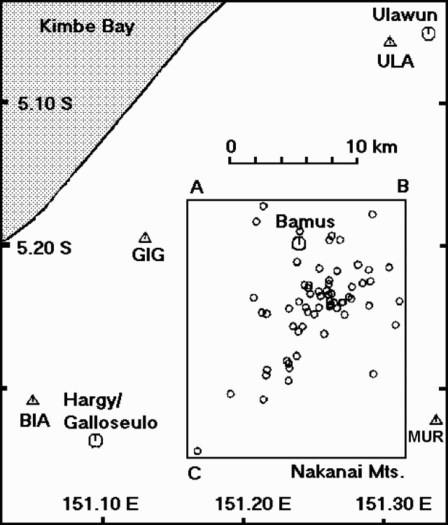 |
Figure 2. Epicenters of seismic events at Bamus, 13-16 February and 6-8 March 1990. Courtesy of RVO. |
"Cross-sections . . . (figure 3) suggest that the main cluster of earthquakes defines an ENE-trending near-vertical fault. This orientation is consistent with the structural pattern evident in the Miocene limestone immediately S of, and underlying, Bamus.
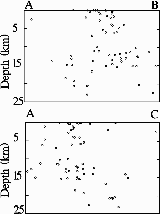 |
Figure 3. Focal depths of seismic events near Bamus during 13-16 February and 6-8 March 1990 projected along lines A-B (top) and A-C (bottom). Horizontal scale (and thus vertical exaggeration) changes from A-B to A-C. Courtesy of RVO. |
"The cause of this seismicity remains uncertain. Its ongoing fluctuating character, and the fact that its swarms include but do not occur in response to larger earthquakes, could be consistent with magmatic injection. On the other hand, ML 5-6 earthquakes are uncommon for magmatic events. Analysis of the magnitude/frequency distribution of the earthquakes shows that the 'b' value is ~1, which is indicative of tectonic earthquake sequences. The seismicity was continuing in early April and was being monitored primarily by the permananent seismograph at Ulawun."
Geological Summary. Symmetrical Bamus volcano, also referred to locally as the South Son, is located SW of Ulawun volcano, known as the Father. The andesitic stratovolcano is covered in rainforest and contains a breached summit crater filled with a lava dome. There is a cone on the southern flank, and a prominent 1.5-km-wide crater with two small adjacent cones halfway up the SE flank. Young pyroclastic-flow deposits are found on the flanks, and residents describe an eruption that took place during the late 19th century.
Information Contacts: I. Itikarai, P. de Saint-Ours, and C. McKee, RVO.