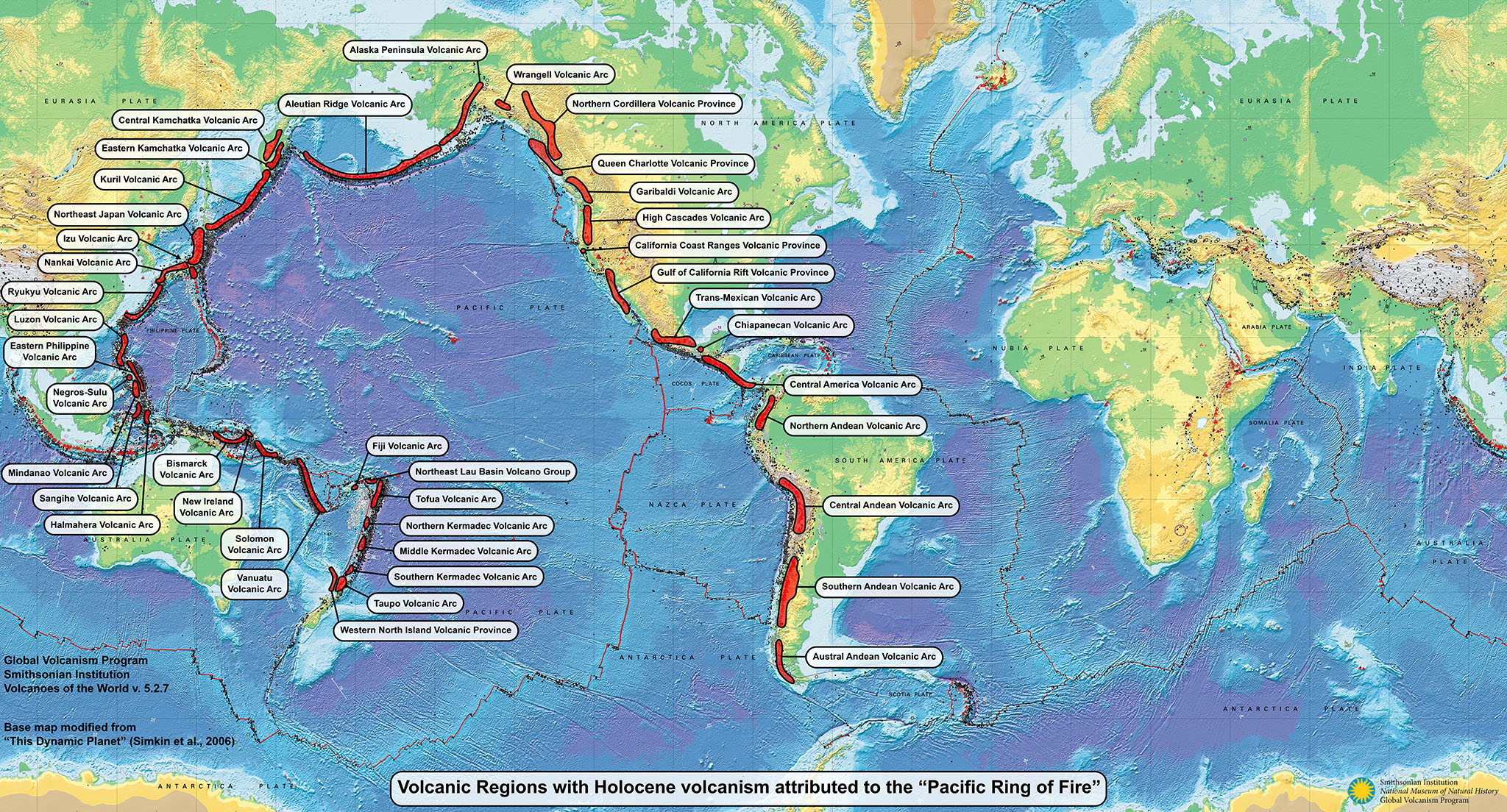
What volcanoes and volcanic regions form the "Pacific Ring of Fire"?
The "Pacific Ring of Fire" (PROF) is not a scientific term, but rather a popular description for many areas around the Pacific Ocean with high levels of volcanic activity that originated more than 100 years before the theory of plate tectonics provided a framework to explain the distribution of most volcanoes. While this is an appealing phrase, these areas do not form a single "ring" structure, adjacent volcanoes do not have connected magma reservoirs, and regions have separate tectonic environments. While hot erupted lava is incandescent, volcanic rocks are not on fire or burning, and volcanic ash is actually tiny fragments of rock. As defined below and shown on the map, the PROF consists of 693 Holocene volcanoes (57% of the 1,222 overall) in 41 different volcanic regions.
Since 1960 there have been eruptions from 196 (28%) of the volcanoes in PROF regions, and from 311 (45%) since 1800; over both time periods about 59% of the volcanoes that have erupted around the world were in these PROF regions. Looking at PROF eruption data compared to the world, since 1960 there were 1,539 eruptions in PROF regions (68% of the global total), and 3,495 since 1800 (65% of the global total). Tectonic subduction environments account for 33 of the PROF regions, 75% of the subduction zones around the world. These statistics are summarized in the table below, and are based on Volcanoes of the World (v. 5.3.4; 30 Dec 2025).
| Statistics Described | Pacific Ring of Fire | Percentage of Global Totals |
|---|---|---|
| All Holocene volcanoes | 693 | 57% of 1,222 |
| Volcanoes with Confirmed Eruptions since 1960 | 196 | 59% of 333 |
| Total count of Confirmed Eruptions since 1960 | 1,539 | 68% of 2,252 |
| Volcanoes with Confirmed Eruptions since 1800 | 311 | 59% of 524 |
| Total count of Confirmed Eruptions since 1800 | 3,495 | 65% of 5,407 |
| Volcanic Regions with Holocene volcanoes | 41 | 35% of 116 |
| Volcanic Regions that are Subduction environments | 33 | 75% of 44 |
Because this is a non-scientific phrase, there is wide variety in definitions of what makes up the PROF. The definition used here attempts to balance what volcanoes a person with basic geographical knowledge might include, along with what groups of volcanoes geologists would consider to be along the boundary of the Pacific Ocean based on plate tectonics.
The PROF is defined here as including regions and volcanoes around the Pacific Ocean at these tectonic plate boundaries: Antarctica:Scotia, Antarctica:South America, Nazca:South America, Cocos:Caribbean, Cocos:North America, Pacific:North America (multiple regions), Juan de Fuca/Gorda:North America, Pacific:Okhotsk, Pacific:Philippine Sea (only northern Izu Arc on or near Honshu), Philippine Sea:Amur, Philippine Sea:Yangtze/Okinawa, Philippine Sea:Sunda (Philippine Mobile Belt), Birds Head:Sunda, Australia:Pacific (multiple regions involving minor plates from Papua New Guinea to New Zealand). Regions are not restricted to active subduction environments, so volcanoes within seven non-subduction regions are included (see table below).
This definition excludes plate-boundary spreading zones, intraplate regions of the oceanic plates (such as hotspot groups in the Galapagos, Hawaii, and Samoa), most of the subduction arcs between the Pacific and Philippine Sea (Izu, Ogasawara, and Marianas), and the volcanoes of Indonesia which are mostly along the Australia:Sunda boundary with no direct connection to the plates of the main Pacific basin. Volcanic Regions that are clearly either inside or outside of the boundary zone volcanoes have also been excluded; some volcanoes within included regions have also been excluded (eg. Izu Volcanic Arc volcanoes away from mainland Japan). Additional information about the regions listed below is available on the "Volcanic Regions and Region Groups" page.
| Volcanic Region | Tectonic Environment |
Holocene Volcanoes |
Active since 1800 |
Eruptions since 1800 |
Active since 1960 |
Eruptions since 1960 |
|---|---|---|---|---|---|---|
| Austral Andean Volcanic Arc | Subduction | 5 | 4 | 14 | 1 | 5 |
| Southern Andean Volcanic Arc | Subduction | 58 | 25 | 269 | 15 | 85 |
| Central Andean Volcanic Arc | Subduction | 52 | 11 | 73 | 6 | 36 |
| Northern Andean Volcanic Arc | Subduction | 35 | 15 | 177 | 9 | 58 |
| Central America Volcanic Arc | Subduction | 62 | 26 | 440 | 19 | 223 |
| Chiapanecan Volcanic Arc | Subduction | 1 | 1 | 2 | 1 | 1 |
| Trans-Mexican Volcanic Arc | Subduction | 21 | 5 | 49 | 2 | 16 |
| Gulf of California Rift Volcanic Province | Rift Zone | 7 | 0 | 0 | 0 | 0 |
| California Coast Ranges Volcano Group | Fracture Zone | 1 | 0 | 0 | 0 | 0 |
| High Cascades Volcanic Arc | Subduction | 19 | 3 | 18 | 1 | 4 |
| Garibaldi Volcanic Arc | Subduction | 8 | 1 | 9 | 0 | 0 |
| Queen Charlotte Volcano Group | Fracture Zone | 4 | 0 | 0 | 0 | 0 |
| Northern Cordilleran Volcanic Province | Intraplate | 13 | 1 | 1 | 0 | 0 |
| Wrangell Volcanic Arc | Subduction | 2 | 1 | 4 | 0 | 0 |
| Alaska Peninsula Volcanic Arc | Subduction | 27 | 13 | 44 | 7 | 25 |
| Aleutian Ridge Volcanic Arc | Subduction | 47 | 25 | 270 | 18 | 136 |
| Central Kamchatka Volcanic Arc | Subduction | 17 | 0 | 0 | 0 | 0 |
| Eastern Kamchatka Volcanic Arc | Subduction | 29 | 13 | 268 | 11 | 140 |
| Kuril Volcanic Arc | Subduction | 66 | 40 | 222 | 18 | 102 |
| Northeast Japan Volcanic Arc | Subduction | 40 | 20 | 211 | 12 | 42 |
| Izu Volcanic Arc | Subduction | 9 | 7 | 82 | 6 | 33 |
| Nankai Volcanic Arc | Subduction | 13 | 6 | 133 | 5 | 39 |
| Ryukyu Volcanic Arc | Subduction | 15 | 10 | 109 | 6 | 51 |
| Luzon Volcanic Arc | Subduction | 9 | 6 | 39 | 3 | 19 |
| Eastern Philippine Volcanic Arc | Subduction | 7 | 4 | 86 | 2 | 36 |
| Negros-Sulu Volcanic Arc | Subduction | 1 | 1 | 31 | 1 | 23 |
| Mindanao Volcanic Province | Intraplate | 6 | 3 | 13 | 0 | 0 |
| Sangihe Volcanic Arc | Subduction | 10 | 10 | 171 | 8 | 84 |
| Halmahera Volcanic Arc | Subduction | 13 | 5 | 71 | 5 | 24 |
| Bismarck Volcanic Arc | Subduction | 24 | 14 | 177 | 11 | 99 |
| Bougainville Volcanic Arc | Subduction | 5 | 1 | 25 | 1 | 9 |
| Solomon Volcanic Province | Intraplate | 6 | 3 | 33 | 1 | 24 |
| Vanuatu Volcanic Arc | Subduction | 15 | 13 | 165 | 10 | 94 |
| Fiji Volcanic Arc | Subduction | 2 | 0 | 0 | 0 | 0 |
| Northeast Lau Basin Volcano Group | Intraplate | 6 | 3 | 10 | 2 | 2 |
| Tofua Volcanic Arc | Subduction | 14 | 12 | 54 | 7 | 25 |
| Northern Kermadec Volcanic Arc | Subduction | 3 | 2 | 30 | 2 | 27 |
| Middle Kermadec Volcanic Arc | Subduction | 5 | 1 | 1 | 1 | 1 |
| Southern Kermadec Volcanic Arc | Subduction | 8 | 1 | 6 | 1 | 6 |
| Taupo Volcanic Arc | Subduction | 6 | 4 | 187 | 4 | 70 |
| Western North Island Volcanic Province | Intraplate | 2 | 1 | 1 | 0 | 0 |
The existence of active volcanoes around the Pacific Ocean was well known to academics by the early 1800's, with some writers using "circle" in their descriptions of this distribution of volcanoes. The first published description of volcanoes around the Pacific Ocean that included "Circle of Fire" and "Ring of Fire" references appears to be from the German geographer Carl Ritter in 1859. The most relevent section is here translated into English: "Their line...extends...from the twin islands of New Zealand [to the] northern Philippines, and presents a row of eighty furnaces burning.... The ring then curves northwards, along the archipelagos of Japan, the Kuriles, Kamchatka, the islands Aleutians and Unalaska, whose fifty volcanoes blaze above the waves of the sea Boreal, or align with the American continent. Finally, the circle is connected to the north of the Cordilleras.... So it is not wrong for us to give this immense circumference of more than three hundred flaming volcanoes the name of the Circle of Fire. This ring of volcanoes [is] open towards the south, while in the north [the continents come] closer together at the Bering Strait.... It is within the ring of fire that the large equatorial zone of the islands inclined to the ecliptic...the sea southern azure, heads through groups swarming from the Philippines to lonely Easter Island." From: Carl Ritter, 1859, On the configuration of the continents and their functions in history, Revue Germanique, v. 8, no. 11, p. 241-267, translated into French by Elisee Reclus).
The French historian and writer Jules Michelet helped popularize this view a couple years later, writing: "From the same post of observation on which I have, in imagination, placed you, [look] towards the arctic hemisphere, and you may discern what Ritter terms the circle of fire. To speak more precisely, it is an opened ring, formed by the volcanoes commencing at the Cordilleras, [extending north to include] those of America, present, for a length of a thousand leagues a succession of sixty gigantic Beacons whose constant eruptions command the abrupt coast and the distant waters. The others, from New Zealand to the North of the Phillipines, number eighty still burning, and a countless host that are extinct. Steering northward, from Japan to Kamschatka, fifty flaming craters dispense their ruddy lights far away to the gloomy seas of the Arctic. In the whole, there is a circle of three hundred active volcanoes around the eastern world." From: Jules Michelet, 1861, The Sea (La Mer.), United States, Rudd & Carleton, p. 46-47.
Volcanic Regions and labels were added by GVP staff on the "This Dynamic Planet Map" (Simkin et al., 2006). A larger version is available for download as a JPG (6 MB, 4096 x 2207) or as an SVG (9 MB).
![]() This image is made available under the Public Domain Dedication CC0 license, but a link to this page and proper attribution as noted below is appreciated.
This image is made available under the Public Domain Dedication CC0 license, but a link to this page and proper attribution as noted below is appreciated.
Global Volcanism Program, 2025. What volcanoes and volcanic regions form the "Pacific Ring of Fire"? (FAQ) in [Database] Volcanoes of the World (v. 5.3.4; 30 Dec 2025). Distributed by Smithsonian Institution, compiled by Venzke, E. https://doi.org/10.5479/si.GVP.VOTW5-2025.5.3