Report on Poas (Costa Rica) — April 1990
Bulletin of the Global Volcanism Network, vol. 15, no. 4 (April 1990)
Managing Editor: Lindsay McClelland.
Poas (Costa Rica) Continued phreatic activity and sulfur emission; crater lake shrink
Please cite this report as:
Global Volcanism Program, 1990. Report on Poas (Costa Rica) (McClelland, L., ed.). Bulletin of the Global Volcanism Network, 15:4. Smithsonian Institution. https://doi.org/10.5479/si.GVP.BGVN199004-345040
Poas
Costa Rica
10.2°N, 84.233°W; summit elev. 2697 m
All times are local (unless otherwise noted)
March activity. Continuous gas emission persisted in March. Gases were carried W and SW by prevailing winds, with major impact on the vegetation, infrastructure, and health of the inhabitants of that area. Winds sometimes changed, carrying gas toward the S and SE where other residents were affected.
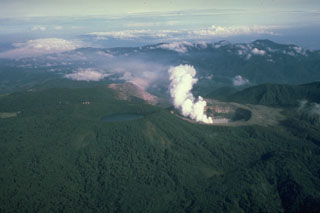
Water level in the crater lake had dropped, leaving isolated pools around a central remnant lake from which most of the activity occurred. Activity included continuous bubbling, small geyser-like eruptions, and intense gas emission (primarily water vapor). Two shallow ponds to the SE were 5-10 m in diameter with a mean temperature of 80°C. On the NE side there were three shallow molten sulfur ponds with a mean temperature of 160°C. In the N part of the crater the most vigorous fumarole emitted orange gas, probably produced by combustion of sulfur, and fine sulfur particles. The gas temperature was about 400°C and a reddish flame was sometimes observed at the base of the gas column.
A permanent seismic station (POA2) continued to record B-type events, with a mean of 337/day in March (figure 26). An A-type earthquake was felt at MM II, 7 km WNW of the summit (in Bajos del Toro) on 8 March at 0239. A series of A-type shocks began to be recorded on 25 March (figure 27). Inhabitants of flank towns, including Poásito (5.5 km SE of the summit), Fraijanes (7 km SSE), and San Pedro de Poás (13.5 km S) felt a M 2.5 earthquake on 1 April at 0204 that was centered 5 km NE of the active crater at 5 km depth. A second felt event, on 2 April at 0215, was centered 6 km SW of the crater at 15 km depth, and had a magnitude of 3.1.
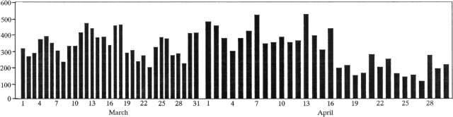 |
Figure 26. Number of low-frequency earthquakes recorded at Poás, March-April 1990. March data courtesy of J. Barquero; April data courtesy of G. Soto. |
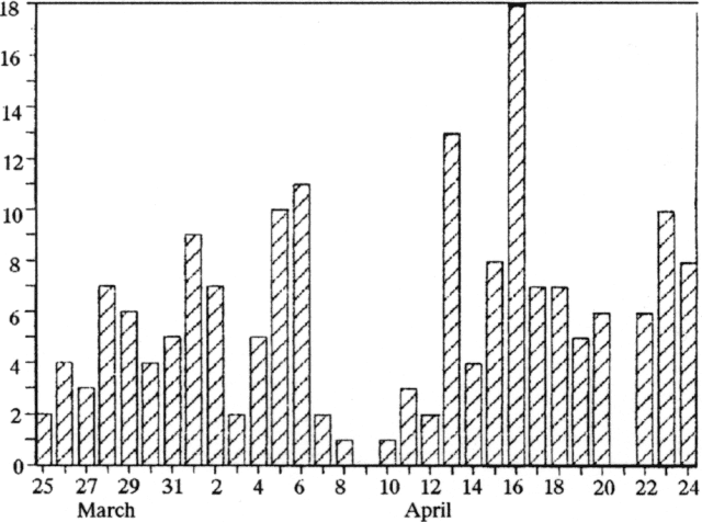 |
Figure 27. Number of A-type earthquakes recorded at Poás, 25 March-24 April 1990. Courtesy of G. Soto. |
Hazel Rymer noted that the March 1990 crater lake was comparable to the lake in April 1989, having apparently evaporated to a low level more rapidly during the 1990 dry season. The base of the mud volcanoes, <1 m above lake level, was 2,282.650 m above sea level on 18 March 1989, while the 30 March 1990 lake level was at 2,278.853 m (elevations tied to a flank benchmark). The location of the hot sulfur lakes, observed last year prior to the ash eruption, was occupied by a vigorous vent, continuously jetting a mixture of sulfurous gases. In early April 1990, boiling mud pools occupied the remainder of the former lake area.
April activity. By the beginning of April, lake level had dropped 4 m since December 1989, shrinking to a small pool in the center of the former lake, where minor phreatic eruptions occurred. Numerous fissures continually emitted gases; at some sites, combustion of sulfur produced flames. By the 18th, the lake's cumulative descent had reached 7 m and it was nearly dry, leaving areas of mud with occasional bubbling caused by the discharge of fumaroles in the bottom of the crater. In addition to activity on the SE part of the crater floor, decsribed in detail below, hot fumaroles were also found in the NE part of the former lake bed (figure 28). The principal fumarole in this area had a vent 2-3 m in diameter. Sprays of very pure yellow sulfur were emitted, as were bluish SO2 and water vapor. The gases were expelled under high pressure with a jet aircraft sound, and burned with yellow-orange flames. At the beginning of the month, temperature (190°C with an infrared thermometer), sound level, and pressure were less than on the 18th, when activity was stronger with temperatures to 793°C. Since 17 April, the vigorous discharge has caused vibrations felt inside the crater and registered by the summit seismic station (VPS-2). The fumarole ejected evaporitic sediments to 75 m height, and similar activity continued through the end of the month. On the 1953-55 dome, fumaroles emitted gas dominated by water, and precipitated sulfur and sulfates. Maximum fumarole temperature (measured by thermocouple) was 90.3°C.
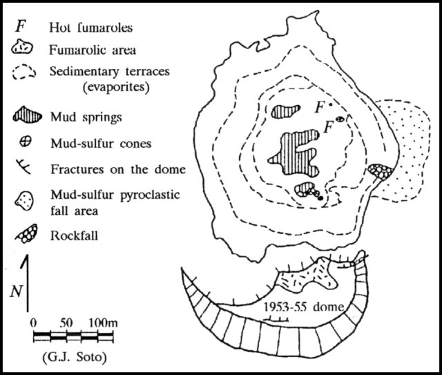 |
Figure 28. Sketch map of the active crater at Poás, 18 April 1990. Courtesy of G. Soto. |
Gases, carrying sediments because of the dryer lake bottom, were carried mainly W and SW, affecting coffee farms, pastures, and especially forests. The inhabitants of various towns, including San Luis (about 13 km SSE of the summit), Cajón, and San Miguel de Grecia (~11 km SW of the summit), suffered health problems, principally with the respiratory tract, vision, and skin allergies. From the night of 26 April through the following day, a wind change concentrated gases strongly in the Parque Nacional del Poás area and toward the SE flank, affecting strawberry crops.
Seismic activity changed substantially from the previous month. Recorded events dropped from 9,460 in March to 9,190 in April. Of these, 9,026 were of low frequency and 159 were volcano-tectonic or A-type. The latter averaged 5/day, a substantial increase. Volcanic tremor also occurred during April, manifested as prolonged vibration of the edifice caused by gases emerging from fumaroles at high pressure.
12 April fieldwork. G. Soto and Clive Oppenheimer climbed into the crater on 12 April at about noon. Bubbling mud pools occupied positions very similar to those of sulfur ponds seen on the SE part of the crater floor in April 1989. Nearly continuous geysering of mud and clumps of solid sulfur was depositing a ring around one of the mud pools. Columns of material ejected in the SE part of the crater reached 10-15 m height, and temperatures measured by an infrared thermometer were between 70 and 100°C. A vent at the NE fumarole site produced a gentle roar and a blue-tinged turbulent plume of gases with pink-orange flames, just visible in daylight, at its base. The plume intermittently stopped burning, turned a thick bright yellow color for a few minutes, then re-ignited and returned to its previous color.
By 0900 the next day, a small dull-yellow sulfur cone had grown at the site of the previous day's geyser-like eruptions. The cone was 2.2 m high with a basal diameter of about 6 m and a crater 2 m across. Small bursts of coagulated, rather plastic sulfur mixed with some silicate occurred at about 1-second intervals, sending ejecta to about 3 m above the rim. A warm, white, acid, vapor cloud was continuously emitted from the crater. The maximum temperature measured by a thermocouple pushed into the substrate at the summit was 97.6°C; when thrown over the rim, the highest measured temperature was 96°C. The crater was filled to within about 0.75 m of the rim with various-sized pellets of somewhat malleable sulfur mixed with silicate, appearing fluidized from agitation in the upward gas stream. Some of the crudely spherical pellets, collected from the sides and base of the cone, were up to 4 cm in diameter. In cross section, they revealed accretionary shells of aggregated sulfur crystals and minor clay alternating with gray clay-rich layers. Shortly before 1130, the vent appeared to become more confined, and the crater was quickly filled by a growing sub-cone. Within minutes, it grew above the old crater rim, forming a perfect cone 3.5-4 m high. A constant spray of sulfur up to 10 m high issued from a narrow vent at the cone's apex for about 30 minutes, dispersing a fine layer to about 15 m downwind. The conduit was often momentarily blocked before being cleared by a slightly stronger gas burst. The continuous ejection of material also built other cones, a few meters high and rich in pyroclastic sulfur, which periodically collapsed and recycled their contents.
29 April fieldwork. When geologists returned to the volcano on 29 April at about 1245, a convecting grayish-white plume, combined from numerous individual vents, was rising to more than 300 m, accompanied by a continuous roar, like a distant jet aircraft, from the center of the crater floor. Moist drops of acid mud fell from the plume, and appeared to form a thin veneer on the inner crater. Three recent cones, presumably of sulfur, on the SE part of the crater floor were also coated with mud and only weakly fuming, with bright yellow sulfur deposited around their conduits. One was irregularly erupting yellowish sulfur. To the NW, small gas eruptions ejected dark clouds of lake sediment, forming a line or cluster of several wide cones. Fumarolic vents varied in color from bright yellow, to different shades of gray, to white. Some had a pronounced tinge of bluish haze. The NE vent, which had been burning on 12 April, was considerably quieter, but a nearby vent was producing a strong plume with pink-orange flames clearly visible at its base. The plume changed color to yellow when combustion ceased; re-ignition was accompanied by a roaring sound. Bright flames also licked the steep inner walls and rim of the remnants of a small cone nearby. A peak thermocouple temperature of 662°C was recorded with the probe in the flames. The origin of the cone was uncertain, although samples of pink-gray ash were collected nearby. At about 1445, a brief, more powerful eruption occurred from the center of the former lake floor. The plume, presumably of non-juvenile material (lake sediments) rose roughly 50 m and produced a hail of blocks that fell noisily to the muddy crater floor.
The next day at 0700, nearly constant eruptions of gas, yellow-tinged apparently dry ash, and blocks, continued from several vents around the center of the crater. Some fresh sulfur had been erupted over one of the old sulfur cones at the SE site. The activity was similar to that observed in the same region in April 1989. At roughly hourly intervals, considerably more powerful activity ejected thick cauliflowering columns of dark ash, accompanied by blocks trailing white vapor above the level of the 1953-55 dome. The episodes lasted 30-50 seconds. There was no evidence that the ash was juvenile, although no samples were obtained. Two gas eruptions were observed at previously inactive sites. The first, at about 0800, occurred very near one of the active phreatic cones. Gas bubbles burst noisily through mud, hurling expanding shells of mud spatter. A similar but much briefer episode occurred 40 m away at about 0810, near the first set of lake sediment terraces. It left a crudely horseshoe-shaped scar in the mud, and a gray fluidized mudflow moved toward the center of the crater. Another strong eruption was seen at 0944, shortly before geologists left the crater, producing a plume that rose to an estimated height of 100 m.
Gravity data. The following is from Hazel Rymer. "Five years of continuous gravity increases at crater-bottom stations, from March 1985 to March 1989, have been recorded by Open University geophysicists. Since 1987, we have also had good elevation control at these stations and have recorded minor deflation. The maximum changes, >200 microGal increases at stations on the 1953 dome, were accompanied by 30 cm deflation (March 1987-March 1989). Gravity variations were similar elsewhere on the crater floor, but elevation changes were less than 6 cm. These data are interpreted in terms of small dendritic magma intrusions and loss of magmatic gas from beneath the lake area (Rymer and Brown, 1987). Evidence to support this model comes from detailed analysis of the energy budget of the crater lake. While gravity increased gradually from 1985 to 1989, the power output through the lake area jumped in 1986 from a fairly steady 190 MW to about 300 MW, maintained to the present. Thus, steady gravity increase was associated with a sustained power output since the stepped increase in 1986.
"Microgravity and elevation data collected by Open Univ geophysicists and Earthwatch volunteers between 19 and 30 March 1990 revealed gravity decreases of about 50 microGal at crater bottom stations with elevations unchanged from 1989 to within 2 cm."
Reference. Rymer, H. and Brown, G., 1987, Gravity changes as a precursor to volcanic eruption of Poás volcano: Nature, v. 342, p. 902-905.
Geological Summary. The broad vegetated edifice of Poás, one of the most active volcanoes of Costa Rica, contains three craters along a N-S line. The frequently visited multi-hued summit crater lakes of the basaltic-to-dacitic volcano are easily accessible by vehicle from the nearby capital city of San José. A N-S-trending fissure cutting the complex stratovolcano extends to the lower N flank, where it has produced the Congo stratovolcano and several lake-filled maars. The southernmost of the two summit crater lakes, Botos, last erupted about 7,500 years ago. The more prominent geothermally heated northern lake, Laguna Caliente, is one of the world's most acidic natural lakes, with a pH of near zero. It has been the site of frequent phreatic and phreatomagmatic eruptions since an eruption was reported in 1828. Eruptions often include geyser-like ejections of crater-lake water.
Information Contacts: J. Barquero, E. Fernández, and V. Barboza, OVSICORI; Hazel Rymer and C.M.M. Oppenheimer, Open Univ; G. Soto and R. Barquero, ICE; Mario Fernández, UCR.