Report on Redoubt (United States) — May 1990
Bulletin of the Global Volcanism Network, vol. 15, no. 5 (May 1990)
Managing Editor: Lindsay McClelland.
Redoubt (United States) Lava dome growth but no strong explosions
Please cite this report as:
Global Volcanism Program, 1990. Report on Redoubt (United States) (McClelland, L., ed.). Bulletin of the Global Volcanism Network, 15:5. Smithsonian Institution. https://doi.org/10.5479/si.GVP.BGVN199005-313030
Redoubt
United States
60.485°N, 152.742°W; summit elev. 3108 m
All times are local (unless otherwise noted)
This report covers the period 15 May-15 June, 1990. "Seismic activity beneath Redoubt remained at low levels throughout the report period (figure 13). A small increase in both shallow and deep earthquakes occurred 13-18 May, staying at this slightly elevated level for about 1 week. Seismicity then returned to pre-13 May levels and has remained low, but still above pre-eruption levels of early December 1989.
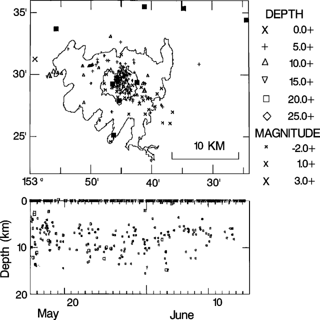 |
Figure 13. Epicenter map (top) and depth vs. time plot (bottom) of earthquakes recorded near Redoubt by AVO, 15 May-15 June, 1990. Squares on the epicenter map mark the positions of seismic stations. |
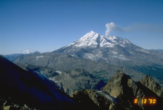
"The lava dome and crater area were obscured by low clouds 5-21 May. During this period, the lava dome grew substantially to what is estimated as the third largest to have formed since the eruption began in mid-December 1989. After 21 May, the dome was enshrouded by clouds until 1 June, when a new lobe was seen on the S side of the dome. AVO crews were able to observe the dome almost daily during the first week in June, but noted no new changes. The early June dome surface was variable in texture with both large smooth massive areas and blocky scoriaceous zones. Precipitates were ubiquitous near the dome's summit. The lava dome has not been observed since 7 June due to cloud cover and steaming in the crater area.
"A small seismic event on 26 May at 1421 appears to have been related to material spalling off the dome. The event was accompanied by a plume that reportedly reached 6500 m, composed primarily of steam. Light ashfall was observed in the crater area and a minor flood event occurred in the upper Drift River valley.
"Nine COSPEC flights yielded SO2 emission rates that ranged from 1200 to 4400 t/d. During the latter half of the report period, SO2 emission rates were below 3100 t/d. Late May and early June rates were lower than those of any similar period since COSPEC measurements began on 20 March."
Geological Summary. Redoubt is a glacier-covered stratovolcano with a breached summit crater in Lake Clark National Park about 170 km SW of Anchorage. Next to Mount Spurr, Redoubt has been the most active Holocene volcano in the upper Cook Inlet. The volcano was constructed beginning about 890,000 years ago over Mesozoic granitic rocks of the Alaska-Aleutian Range batholith. Collapse of the summit 13,000-10,500 years ago produced a major debris avalanche that reached Cook Inlet. Holocene activity has included the emplacement of a large debris avalanche and clay-rich lahars that dammed Lake Crescent on the south side and reached Cook Inlet about 3,500 years ago. Eruptions during the past few centuries have affected only the Drift River drainage on the north. Historical eruptions have originated from a vent at the north end of the 1.8-km-wide breached summit crater. The 1989-90 eruption had severe economic impact on the Cook Inlet region and affected air traffic far beyond the volcano.
Information Contacts: AVO Staff.