Report on Purace (Colombia) — August 1990
Bulletin of the Global Volcanism Network, vol. 15, no. 8 (August 1990)
Managing Editor: Lindsay McClelland.
Purace (Colombia) Sulfur-rich summit fumaroles and flank hot springs
Please cite this report as:
Global Volcanism Program, 1990. Report on Purace (Colombia) (McClelland, L., ed.). Bulletin of the Global Volcanism Network, 15:8. Smithsonian Institution. https://doi.org/10.5479/si.GVP.BGVN199008-351060
Purace
Colombia
2.3095°N, 76.3948°W; summit elev. 4650 m
All times are local (unless otherwise noted)
"The summit crater and hydrothermal sites were visited on 6 and 7 August, with María Luisa Monsalve (INGEOMINAS, Popayán). The Coconucos-Aguas Herviendo hot springs, 5.5 km WNW of the crater at ~2,900 m elev, in the Río Grande valley, are a very popular developed site, with concrete pools and restaurant. Maximum water temperatures were measured in the small central bubbling spring and were 74°C (unchanged since December 1989). pH was not measured on this trip but was 6.2 in December. Coconucos-Aguas Tibias, ~ 2 km S of Aguas Herviendo (6 km WSW of the crater), has one small concrete pool with a natural spring ~300 m to the S. Maximum temperatures were 61°C. Giggenbach-type gas samples were collected from the bubbles at both sites. A third hydrothermal site, Pilimbala, is at 3,350 m elev and 7.8 km from the crater. This site is maintained by the national park service (INDERENA) and has large tile-lined pools, filled with water from the single large spring. Maximum temperature was 31°C. No pH was measured and no bubbles were observed in the spring. Although there was abundant deposition of sulfur within the hot spring, there was little odor of H2S.
"At the nearby mine site (3,550 m elev), the swimming pool spring was sampled again. The temperature was 47°C, unchanged since December 1989, when the pH was 4.3. The odor of H2S was very strong and abundant sulfur deposition was evident in the spring and swimming pool.
"The crater was visited on a day with almost no visibility and during a freezing rain. A fumarole field is located on a circumferential crack, ~ 100 m outside of the crater, and on a line between the crater and the mine (340°). The summit crater is ~ 400 m in diameter and ~ 100 m deep. A central graben, oriented 100°, is located in the deepest part of the crater and all of the crater fumaroles are located within it. The maximum temperature in the westernmost fumarole field was 89°C (unchanged). The fumarole field covered an area of ~10 m diameter and had a typical low-temperature appearance, with abundant native sulfur and aluminum chloride deposition over a large area. Some collapse of the fumarole had apparently taken place since the December 1989 visit. During the first visit to the crater, in April 1988, the fumaroles looked as if they were hotter than in August 1990 but no temperatures were taken. The summit fumaroles were basically steam and the system appeared to be dominated by recirculation of groundwater, with little magmatic input at this time.
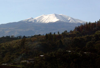
Geological Summary. Puracé is an active andesitic volcano with a 600-m-diameter summit crater at the NW end of the Los Coconucos Volcanic Chain. This volcanic complex includes nine composite and five monogenetic volcanoes, extending from the Puracé crater more than 6 km SE to the summit of Pan de Azúcar stratovolcano. The dacitic massif which the complex is built on extends about 13 km NW-SE and 10 km NE-SW. Frequent small to moderate explosive eruptions reported since 1816 CE have modified the morphology of the summit crater, with the largest eruptions in 1849, 1869, and 1885.
Information Contacts: S. Williams, Louisiana State Univ; J. Stix and E. Fontaine, Univ de Montréal.