Report on Kelud (Indonesia) — September 1990
Bulletin of the Global Volcanism Network, vol. 15, no. 9 (September 1990)
Managing Editor: Lindsay McClelland.
Kelud (Indonesia) February eruption created new pit crater and emptied crater lake; high-temperature gas emission
Please cite this report as:
Global Volcanism Program, 1990. Report on Kelud (Indonesia) (McClelland, L., ed.). Bulletin of the Global Volcanism Network, 15:9. Smithsonian Institution. https://doi.org/10.5479/si.GVP.BGVN199009-263280
Kelud
Indonesia
7.935°S, 112.314°E; summit elev. 1730 m
All times are local (unless otherwise noted)
The following is from Patrick Allard. "Joint investigations . . . were conducted by volcanologists from VSI, the French CNRS, and Paris Univ on 19 July, 25 August, and 2 September. Many months after the 10-12 February explosive eruption, intense activity was persisting.
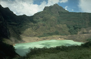
"The topography of the crater (figure 1) was deeply modified by the eruption. The former crater lake (~2 x 10⁶ m3), blasted out during the initial eruptive phase, has been replaced by a pit crater ~450 x 500 m wide and 100 m deep. The walls of the pit are very steep and unstable, leading to frequent landslides. A lake of muddy water (85°C), 150 x 160 m, occupies its SE floor. Strong, loud emission of steam and gas (193°C, ~14 bars pressure for a steam-saturated reservoir) continuously occurs from two blowing vents N of the lake, contributing much of the plume that rises a few hundred meters above the crater rim. Gas samples were taken from these vents 19 July.
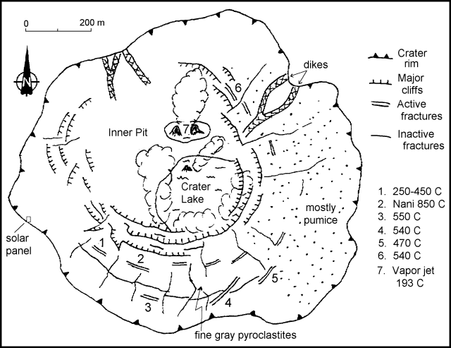 |
Figure 1. Sketch of Kelut's crater showing main sites of gas emission, August-September 1990. Courtesy of Patrick Allard. |
"Thick tephra layers from the February eruption have accumulated in the remaining parts of the crater, dipping with a gentle slope toward the inner pit. These layers are cut by arcuate fractures, more or less concentric to the pit walls, as well as by smaller radial fissures, which probably result from both compaction and sliding of the recent deposits. Some arcuate fractures are >1 m wide and 20 m deep. During our August visit it was discovered that high-temperature gases (>500°C, and up to 850°C at 1 m depth) escape from many of these, red glow being visible in the daylight at some sites. Gas plumes, varying in color from white to blue, mark the active vents, and the fractures and rims are blanketed with abundant sublimates. While some fractures are extinct, others are very recent, since their opening projected blocks and lapilli above the upper mud layer that formed during the rainy season (February-June). The release of high-temperature gases through these fractures may reflect either late (passive) degassing of cooling pyroclastic deposits from the February eruption or active degassing of a shallow magma body (residual intrusion?). Analysis of both stable and radioactive components in gas and aerosol samples collected at different sites may provide some geochemical insight into this question, as well as into the possibility of further phreatic or even phreato-magmatic events.
"Huge devastation in the Kelut area attests to the power of the February eruption. VSI estimated the total volume of erupted tephra at 120 x 106 m3 and that of lahar deposits at 24 x 106 m3. Given this volume and other parameters such as the maximum eruptive column height (~12 km) and the duration of the magmatic phase (~8 hours as a whole; 15:01), a VEI of 3 (high) to 4 (low) can be attributed to this eruption.*
"Rainfall over the volcano averages 5-7 x 10⁶ m3/year, so the crater lake could re-form during the next year or more, depending on the rate of heat output. The explosive blast of the crater lake and consequent lahar formation were responsible for most casualties from the past Kelut eruptions in 1919 (5,160 casualties), 1951 (7), and 1966 (210), even though this hazard was successfully mitigated by VSI during the 1990 eruption."
*Both VSI's estimate of tephra volume (>100 x 106 m3) and measurements of eruption cloud height meet the criteria of Newhall and Self (1982) for a VEI of 4. Preliminary temperature analysis from satellite images suggested that the top of the dense portion of the plume was at ~12 km altitude (15:01), but lidar data from the RV Akademik Korolev detected layers above 20 km altitude, well into the stratosphere, in the central and western Pacific shortly after the eruption [and the SAGE II instrument detected aerosols to 25 km] (see Atmospheric Effects, GVNB 15:08 and 15:12]).
Reference. Newhall, C.G., and Self, S., 1982, The Volcanic Explosivity Index (VEI): an estimate of explosive magnitude for historical volcanism: JGR (Oceans and Atmospheres), v. 87, no. C2, p. 1231-1238.
Geological Summary. The relatively inconspicuous Kelud stratovolcano contains a summit crater lake that has been the source of some of Indonesia's most deadly eruptions. A cluster of summit lava domes cut by numerous craters has given the summit a very irregular profile. Satellitic cones and lava domes are also located low on the E, W, and SSW flanks. Eruptive activity has in general migrated in a clockwise direction around the summit vent complex. More than 30 eruptions have been recorded since 1000 CE. The ejection of water from the crater lake during the typically short but violent eruptions has created pyroclastic flows and lahars that have caused widespread fatalities and destruction. After more than 5,000 people were killed during an eruption in 1919, an engineering project to drain the crater lake lowered the surface by more than 50 m. The 1951 eruption deepened the crater by 70 m, leaving 50 million cubic meters of water after the damaged drainage tunnels were repaired. Following more than 200 deaths in the 1966 eruption, a new deeper tunnel was constructed, and the lake's volume before the 1990 eruption was only about 1 million cubic meters.
Information Contacts: VSI; P. Allard, G. Polian, and J-C. Sabroux, CNRS, France; A. Jambon and B. Marty, Univ Paris, France.