Report on Nevado del Ruiz (Colombia) — September 1990

Bulletin of the Global Volcanism Network, vol. 15, no. 9 (September 1990)
Managing Editor: Lindsay McClelland.
Nevado del Ruiz (Colombia) Ash emissions with associated tremor; seismicity increases
Please cite this report as:
Global Volcanism Program, 1990. Report on Nevado del Ruiz (Colombia) (McClelland, L., ed.). Bulletin of the Global Volcanism Network, 15:9. Smithsonian Institution. https://doi.org/10.5479/si.GVP.BGVN199009-351020
Nevado del Ruiz
Colombia
4.892°N, 75.324°W; summit elev. 5279 m
All times are local (unless otherwise noted)
The number of high-frequency earthquakes and total seismic energy release increased during September (figure 41). A swarm of high-frequency earthquakes on 17 September was centered NW of the summit at depths of 3.0-7.0 km (figure 42). Pulses of volcanic tremor (periods of 0.2-0.3 seconds) were recorded throughout the month, and were occasionally associated with small ash emissions. Tremor was continuous from 27 September through the end of the month, with associated ash emissions. Although dry-tilt did not show any significant changes, 6.56 µrad of deformation were measured 7 km from the summit (at Refugio station) on 4 and 8 September, with coincident seismic activity. The average SO2 flux for the month, measured by COSPEC, was 2,448 t/d. A "Japanese box" sampling device (an open beaker containing a 10 N KOH solution placed within the volcanic plume), operated 2.5 km from the summit in July, contained 1.52 mole % SO2 and 0.59 mole % HCl.
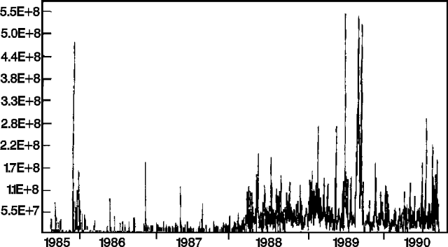 |
Figure 41. Daily seismic energy release at Ruiz, 1985-90. Courtesy of INGEOMINAS. |
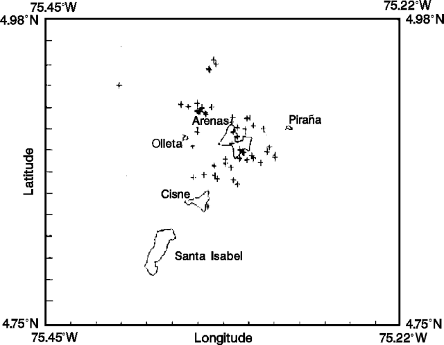 |
Figure 42. Epicenters of 54 high-frequency earthquakes at Ruiz, September 1990. Courtesy of INGEOMINAS. |
Geological Summary. Nevado del Ruiz is a broad, glacier-covered volcano in central Colombia that covers more than 200 km2. Three major edifices, composed of andesitic and dacitic lavas and andesitic pyroclastics, have been constructed since the beginning of the Pleistocene. The modern cone consists of a broad cluster of lava domes built within the caldera of an older edifice. The 1-km-wide, 240-m-deep Arenas crater occupies the summit. The prominent La Olleta pyroclastic cone located on the SW flank may also have been active in historical time. Steep headwalls of massive landslides cut the flanks. Melting of its summit icecap during historical eruptions, which date back to the 16th century, has resulted in devastating lahars, including one in 1985 that was South America's deadliest eruption.
Information Contacts: C. Carvajal, INGEOMINAS, Manizales.