Report on Galeras (Colombia) — January 1991

Bulletin of the Global Volcanism Network, vol. 16, no. 1 (January 1991)
Managing Editor: Lindsay McClelland.
Galeras (Colombia) Some seismicity stronger; minor deformation; fumarole data
Please cite this report as:
Global Volcanism Program, 1991. Report on Galeras (Colombia) (McClelland, L., ed.). Bulletin of the Global Volcanism Network, 16:1. Smithsonian Institution. https://doi.org/10.5479/si.GVP.BGVN199101-351080
Galeras
Colombia
1.22°N, 77.37°W; summit elev. 4276 m
All times are local (unless otherwise noted)
Low-frequency earthquakes were stronger (as measured by reduced displacement; figure 29) and more numerous during January. A slight increase in energy released by high-frequency earthquakes was also recorded. The high-frequency events were located around the crater and to the SE (figure 30), at depths of 1.7-4.1 km. Long-period events and tremor activity decreased.
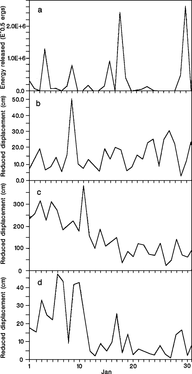 |
Figure 29. Daily released energy of high-frequency earthquakes (a), and daily reduced displacement of: low-frequency earthquakes (b), long-period earthquakes (c), and tremor pulses (d) at Galeras, January 1991. Courtesy of INGEOMINAS. |
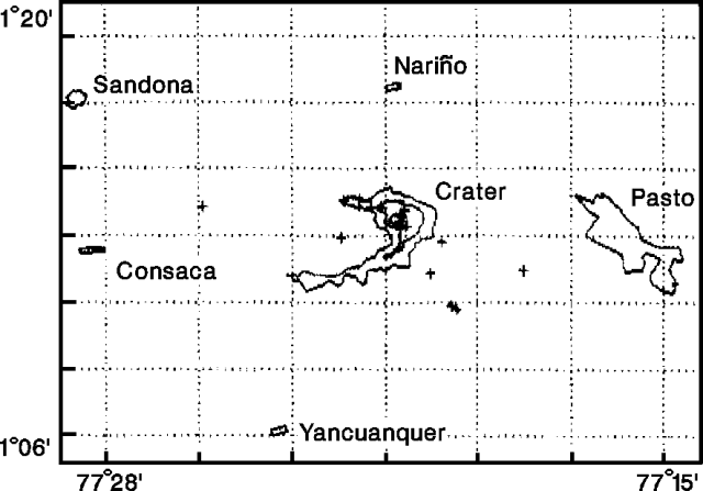 |
Figure 30. Epicenters of 13 high-frequency earthquakes at Galeras, January 1991. Courtesy of INGEOMINAS. |
Dry tilt and level-line measurements showed small variations in deformation during January. The tangential component of the Crater station tiltmeter recorded steady inflation, with a total increase of 9 µrad during the month. A tiltmeter 2 km E of the crater (Peladitos) recorded inflation between 12 and 24 January (14 µrad radial and 12 µrad tangential), and rapid deflation on 24 January (figure 31).
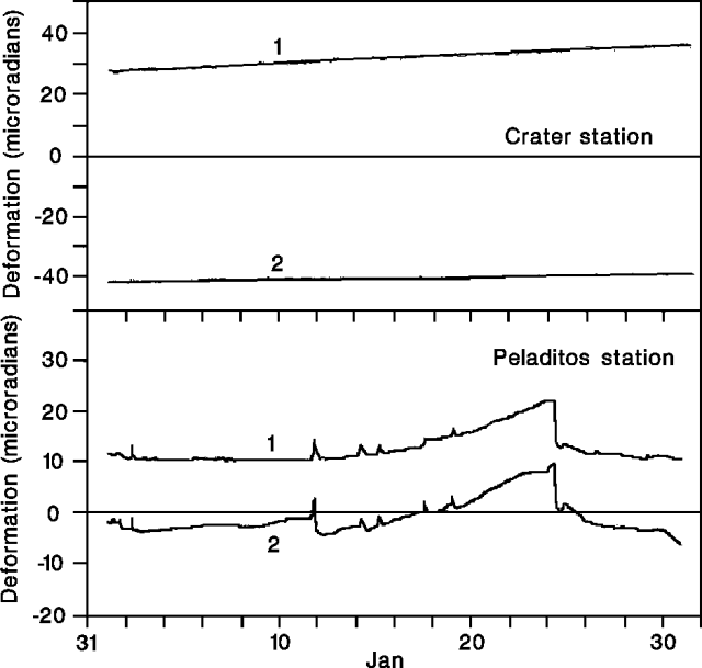 |
Figure 31. Radial (1) and tangential (2) deformation at Peladitos station tiltmeter, 2 km E of the active crater at Galeras, January 1991. Courtesy of INGEOMINAS. |
The January SO2 flux, measured by COSPEC, was moderate, and temperatures at Calvache and Deformes fumaroles (figure 32) remained stable with respect to December measurements (table 3). A small increase in temperature was measured at the incandescent Besolima fumaroles, located in the W-sector fissure that opened in early September 1990.
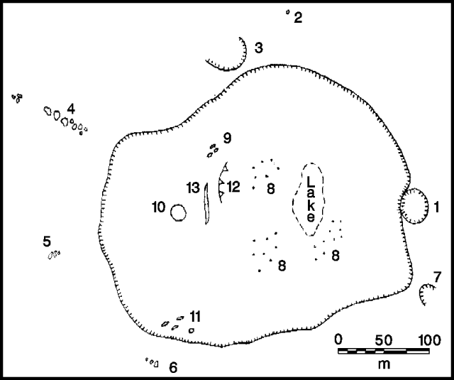 |
Figure 32. Sketch of the active crater at Galeras, January 1991, showing the locations of fumaroles and major morphologic features. See table 3 for fumarole names. Fumarole 7 is unnamed. 12 – zone of collapse, 13 – fissure. Courtesy of INGEOMINAS. |
Table 3. Fumarole activity (visual estimate of emission rate) and temperature ranges measured by thermocouple in accessible vents at Galeras, January 1991. Numbers correspond to locations shown in figure 32.
| Fumarole | Name | Dec 1989 | Aug 1990 | Sep 1990 | Dec 1990 | Jan 1991 | Jan 1991 Activity |
| 1 | El Pinta | -- | -- | -- | -- | very low | |
| 2 | Calvache | 88°C | 88°C | -- | -- | 88-92°C | low to moderate |
| 3 | El Paisita | -- | -- | -- | -- | 70-80°C | very low |
| 4 | Besolima | -- | -- | 738°C | 550-575°C | 520-738°C | very high (incandescence) |
| 5 | Chaves | -- | -- | -- | -- | 90-102°C | moderate |
| 6 | Deformes | 243°C | 243°C | -- | 250-265°C | 250-265°C | high |
| 8 | Campo Fumarlico | -- | -- | -- | -- | -- | high |
| 9 | Bernardo | -- | -- | -- | -- | -- | very high (incandescence) |
| 10 | Portillas | -- | -- | -- | -- | -- | very high (incandescence) |
| 11 | Campo Joyeria | -- | -- | -- | -- | -- | very high (incandescence) |
Geological Summary. Galeras, a stratovolcano with a large breached caldera located immediately west of the city of Pasto, is one of Colombia's most frequently active volcanoes. The dominantly andesitic complex has been active for more than 1 million years, and two major caldera collapse eruptions took place during the late Pleistocene. Long-term extensive hydrothermal alteration has contributed to large-scale edifice collapse on at least three occasions, producing debris avalanches that swept to the west and left a large open caldera inside which the modern cone has been constructed. Major explosive eruptions since the mid-Holocene have produced widespread tephra deposits and pyroclastic flows that swept all but the southern flanks. A central cone slightly lower than the caldera rim has been the site of numerous small-to-moderate eruptions since the time of the Spanish conquistadors.
Information Contacts: INGEOMINAS-OVP.