Report on Kelud (Indonesia) — March 1991
Bulletin of the Global Volcanism Network, vol. 16, no. 3 (March 1991)
Managing Editor: Lindsay McClelland.
Kelud (Indonesia) Continued fumarolic activity; 1991 pyroclastic-flow deposits to 400°C; small rain-induced lahars
Please cite this report as:
Global Volcanism Program, 1991. Report on Kelud (Indonesia) (McClelland, L., ed.). Bulletin of the Global Volcanism Network, 16:3. Smithsonian Institution. https://doi.org/10.5479/si.GVP.BGVN199103-263280
Kelud
Indonesia
7.935°S, 112.314°E; summit elev. 1730 m
All times are local (unless otherwise noted)
The press reported on 26 November that four people had recently been killed by lahars that overflowed a river channel in the Blitar region (~30 km S of the summit).
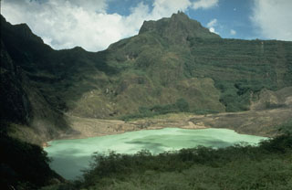
During March fieldwork, gas was emitted from numerous fissures within and around the small light-green pool in the SE part of the former crater lake (15:09). The small hummocky area in the center of the former lake bed expelled hot gases (temperatures between 200 and 240°C, up from ~190°C in late 1990) under high pressure with a jet aircraft sound and very strong sulfurous odor.
Workers continued to quarry the still-hot (90-400°C) pyroclastic-flow deposits (~25 m thick) that buried the mouth of the Ampera Tunnel, in the SW side of the crater.
The average daily rainfall in March was 46 mm, and lahars were reported in the Ngobo (WNW flank) and Sumberagung (W flank) rivers. The latter river overflowed in the town of the same name (7 km W of the crater), but no victims or significant damages were reported. An average of two tectonic earthquakes (but no volcanic earthquakes) were recorded daily.
Geological Summary. The relatively inconspicuous Kelud stratovolcano contains a summit crater lake that has been the source of some of Indonesia's most deadly eruptions. A cluster of summit lava domes cut by numerous craters has given the summit a very irregular profile. Satellitic cones and lava domes are also located low on the E, W, and SSW flanks. Eruptive activity has in general migrated in a clockwise direction around the summit vent complex. More than 30 eruptions have been recorded since 1000 CE. The ejection of water from the crater lake during the typically short but violent eruptions has created pyroclastic flows and lahars that have caused widespread fatalities and destruction. After more than 5,000 people were killed during an eruption in 1919, an engineering project to drain the crater lake lowered the surface by more than 50 m. The 1951 eruption deepened the crater by 70 m, leaving 50 million cubic meters of water after the damaged drainage tunnels were repaired. Following more than 200 deaths in the 1966 eruption, a new deeper tunnel was constructed, and the lake's volume before the 1990 eruption was only about 1 million cubic meters.
Information Contacts: W. Modjo, VSI; AP.