Report on Irazu (Costa Rica) — July 1991

Bulletin of the Global Volcanism Network, vol. 16, no. 7 (July 1991)
Managing Editor: Lindsay McClelland.
Irazu (Costa Rica) Seismicity remains high; crater lake level rises
Please cite this report as:
Global Volcanism Program, 1991. Report on Irazu (Costa Rica) (McClelland, L., ed.). Bulletin of the Global Volcanism Network, 16:7. Smithsonian Institution. https://doi.org/10.5479/si.GVP.BGVN199107-345060
Irazu
Costa Rica
9.979°N, 83.852°W; summit elev. 3436 m
All times are local (unless otherwise noted)
In July, the turquoise-green crater lake continued to rise, eventually covering 2/3 of the crater floor, including several fumaroles that formed during early-mid June. Sulfur deposits had been observed at some of these fumaroles. On 17 July, the lake was 150 x 100 m, with a maximum depth of 2 m. Water temperatures increased with proximity to the bubbling springs (90°C), mud pots, and roaring fumaroles, ranging from 35°C to 55°C (compared to 30-48°C in late June). The lake had pH of 3.7.
Seismicity remained at high levels in July, but was decreased in comparison to late May-June (16:5-6). July's highest seismicity occurred on the 4th, when 75 earthquakes were recorded (seismic station IRZ2, 5 km WSW, Univ Nacional network; figure 3), 34 of which occurred in a NW-SE trend. The 4 July earthquakes (M 1.5-2.7) were centered 0.6-10 km from the crater at <10 km depth. Tremor episodes and B-type earthquakes continued to be recorded in July.
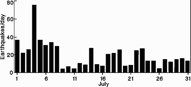 |
Figure 3. Daily number of earthquakes at Irazú, July 1991. Courtesy of Universidad Nacional. |
Geological Summary. The massive Irazú volcano in Costa Rica, immediately E of the capital city of San José, covers an area of 500 km2 and is vegetated to within a few hundred meters of its broad summit crater complex. At least 10 satellitic cones are located on its S flank. No lava effusion is known since the eruption of the Cervantes lava flows from S-flank vents about 14,000 years ago, and all known Holocene eruptions have been explosive. The focus of eruptions at the summit crater complex has migrated to the W towards the main crater, which contains a small lake. The first well-documented eruption occurred in 1723, and frequent explosive eruptions have occurred since. Ashfall from the last major eruption during 1963-65 caused significant disruption to San José and surrounding areas. Phreatic activity reported in 1994 may have been a landslide event from the fumarolic area on the NW summit (Fallas et al., 2018).
Information Contacts: R. Barquero, Guillermo Alvarado, and Alain Creussot, ICE; Mario Fernández and Hector Flores, Sección de Sismología y Vulcanología, Univ de Costa Rica; J. Barquero, E. Fernández, V. Barboza, and J. Brenes, OVSICORI.