Report on Merapi (Indonesia) — November 1991

Bulletin of the Global Volcanism Network, vol. 16, no. 11 (November 1991)
Managing Editor: Lindsay McClelland.
Merapi (Indonesia) Degassing but no apparent lava dome growth; deformation data from 1988-90 and seismicity from 1990-91
Please cite this report as:
Global Volcanism Program, 1991. Report on Merapi (Indonesia) (McClelland, L., ed.). Bulletin of the Global Volcanism Network, 16:11. Smithsonian Institution. https://doi.org/10.5479/si.GVP.BGVN199111-263250
Merapi
Indonesia
7.54°S, 110.446°E; summit elev. 2910 m
All times are local (unless otherwise noted)
The volume of the lava dome apparently remained stable at 6.8 x 10⁶ m3, and the temperature of the nearby solfatara was 806°C in early December, about the same as in November. Degassing continued, with the vapor column reaching 300 m height. December COSPEC measurements yielded SO2 emission rates of 73 t/d during the first week and 87 t/d the second week. Average plume velocity was 0.9-3.4 m/second. December is generally a rainy month at Merapi, and geologists were closely monitoring lahar hazards. Moderate seismicity continued to be recorded by nearby instruments (table 4).
Table 4. Local seismicity at Merapi during the first two weeks of December 1991. Courtesy of VSI.
| Dates | Volcanic | Multiphase volcanic | Avalanche | Tectonic |
| Dec 1991 - Week 1 | 3 | 5 | 10 | 13 |
| Dec 1991 - Week 2 | 13 | 4 | 6 | 4 |
[The following seismicity and deformation data were excerpted from 17:3] Comparison of distance measurements across the summit in June-July 1988 and September 1990, during to shortly after the later stages of the previous dome-building eruption, showed expansions that reached nearly 1 m (figure 1). Seismic data from 1990-91 show a strong increase in B-type events during the August 1990 crisis. B-type seismicity remained at increased levels through 1991 (figure 2).
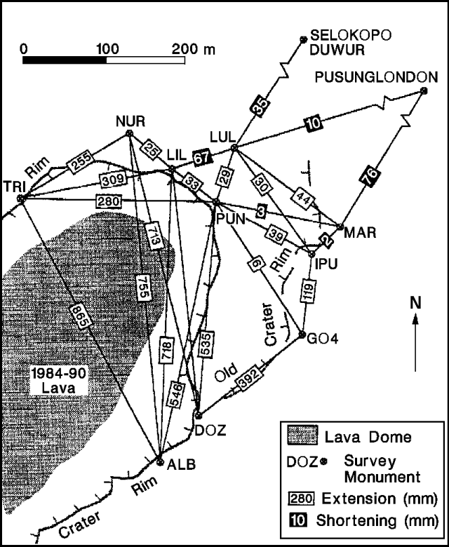 |
Figure 1. Distance changes (in mm) at Merapi, between measurements in June-July 1988 and September 1990. Data collected by B. Voight, K. Young, and staff of the Merapi Volcano Observatory. Courtesy of B. Voight. |
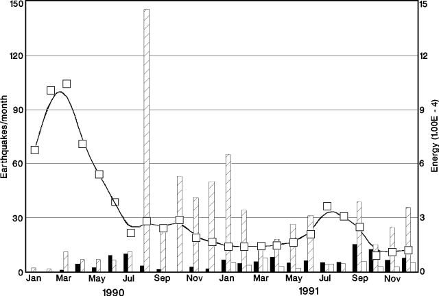 |
Figure 2. Monthly number of volcanic earthquakes (bars) and the inverse of seismic energy release (calculated after Voight, 1988), at Merapi, 1990-91. Courtesy of B. Voight. |
Reference: Voight, B., 1988, A model for prediction of volcanic eruptions: Nature, v. 332, p. 125-130.
Geological Summary. Merapi, one of Indonesia's most active volcanoes, lies in one of the world's most densely populated areas and dominates the landscape immediately north of the major city of Yogyakarta. It is the youngest and southernmost of a volcanic chain extending NNW to Ungaran volcano. Growth of Old Merapi during the Pleistocene ended with major edifice collapse perhaps about 2,000 years ago, leaving a large arcuate scarp cutting the eroded older Batulawang volcano. Subsequent growth of the steep-sided Young Merapi edifice, its upper part unvegetated due to frequent activity, began SW of the earlier collapse scarp. Pyroclastic flows and lahars accompanying growth and collapse of the steep-sided active summit lava dome have devastated cultivated lands on the western-to-southern flanks and caused many fatalities.
Information Contacts: VSI; UPI; B. Voight, Pennsylvania State Univ.