Report on Etna (Italy) — December 1991
Bulletin of the Global Volcanism Network, vol. 16, no. 12 (December 1991)
Managing Editor: Lindsay McClelland.
Etna (Italy) Lava from SE-flank fissures covers about 5 km2; barrier constructed
Please cite this report as:
Global Volcanism Program, 1991. Report on Etna (Italy) (McClelland, L., ed.). Bulletin of the Global Volcanism Network, 16:12. Smithsonian Institution. https://doi.org/10.5479/si.GVP.BGVN199112-211060
Etna
Italy
37.748°N, 14.999°E; summit elev. 3357 m
All times are local (unless otherwise noted)
The following, from R. Romano with additional information from J.C. Tanguy, supersedes the preliminary press report in 16:11. Information from Tanguy about the beginning of the eruption was collected thanks to G. Patanè, S. Imposa, R. Cristofolini, A. & O. Nicoloso, and G. Scarpinati.
A SE-flank fissure eruption began near the base of Southeast Crater early 14 December. Activity ended that day from the initial vents, but fissures propagated downslope where more vigorous lava production began the next morning. The eruption produced a substantial lava field and was continuing in mid-January.
After intense Strombolian activity at ... Bocca Nuova and Southeast Crater, eruptive fissures opened during the early morning of 14 December. These extended ~ 1 km SSE from the base of Southeast Crater (figure 42). Strong harmonic tremor was recorded between 0220 and 0420 by Univ di Catania seismometers. Ejection of lava fragments built modest cones and scoria ramparts along the fracture system, while small lava flows were extruded from some vents. More consistent lava production at the end of the fracture system fed a flow that advanced down the W wall of the Valle del Bove, branching into two lobes. These moved E, but did not exceed 1 km in length, reaching ~2,400 m altitude. When chief guide A. Nicoloso reached the area at about 0800, lava production had nearly stopped, although strong gas emission continued at Bocca Nuova and Southeast Crater. Activity from the fissures ceased completely during the morning. Another modest-sized eruptive fissure, oriented NE-SW, opened at the NE base of Southeast Crater, ejecting hot pyroclastic material.
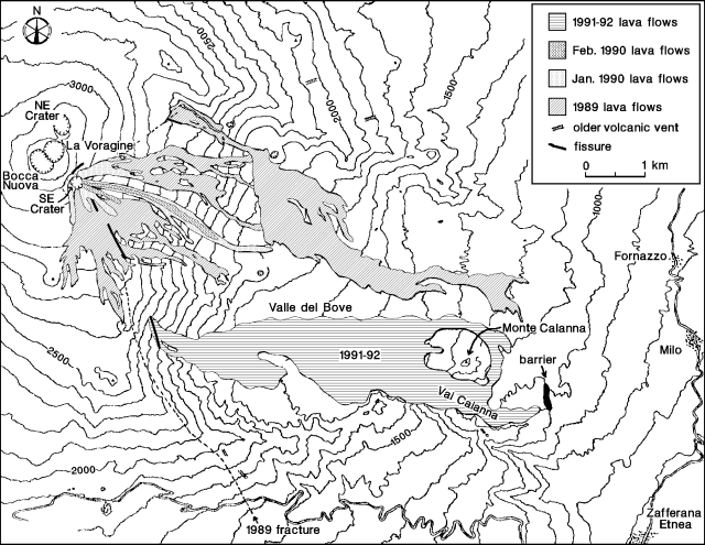 |
Figure 42. Topographic map showing the 1989 and 1990 flows, and preliminary locations of the 1991-92 lava, eruptive fissures, and the barrier constructed in Val Calanna. The Piano del Trifoglietto is the broad plain covered by 1991-92 lava in the area of the "1991-92" label. Courtesy of R. Romano, T. Caltabiano, P. Carveni, and M.F. Grasso. |
During the night, the NNW-SSE fissures that had been active the previous morning continued to propagate downslope. A second seismic crisis heralded the opening, at about 0245, of two sub-parallel eruptive fissures. These developed along a non-eruptive segment of the 1989 eruption's SE fracture, on the W wall of the Valle del Bove between roughly 2,400 and 2,200 m altitude, a total length of ~ 400 m. Strombolian activity began immediately along the new fissures and lava flowed E from the fissures' ends, extending ~ 1.5 km along the floor of the Valle del Bove by 0900 (observation by G. Scarpinati). The flows reached the base of the Valle del Bove during the afternoon, and advanced on the Piano del Trifoglietto, a plain at ~ 1,500 m altitude. That evening, at 2103, a strong shock was felt near Etna and to ~ 75 km SE (in the Siracusa area). Other isolated shocks and swarms of events with M <4 were recorded, particularly during the first few days of the eruption.
In the days that followed, Strombolian activity, sometimes intense, occurred from several points along the fissures, building small cones and scoria ramparts. Impressive phreatomagmatic explosions, accompanied by loud detonations, were clearly felt in towns at the foot of the volcano, especially during the eruption's first few days. The effusive activity created a system of lava flows, some with fronts hundreds of meters wide, which generally moved east, in the Piano del Trifoglietto.
By 20 December, lava had reached ~ 1,500 m altitude and superposition of lava flows began to be observed. During the evening of 23 December, a very wide lava front reached the Salto della Giumenta (at the head of the Val Calanna, ~ 4.5 km from the vent) and a few flows descended into it the next morning. Lava flows almost completely covered Val Calanna during the succeeding days, destroying orchards and drinking water facilities. On 2 January, a very wide flow front, ~ 10 m thick, had reached 950 m altitude (~ 5.5 km from the vent) and was advancing slowly. Construction began that day on a containment barrier along the E side of Val Calanna.
An extensive lava field had formed in the Piano del Trifoglietto, with individual lobes frequently superposing and combining. Overflows began from the N part of the lava field about 2 January, forming a separate flow around the N side of Monte Calanna on 5 January and rejoining the stagnant lava front in Val Calanna on the 7th. Flow fronts in Val Calanna had stopped by the morning of 9 January, while active superposed lobes were noted on the lava that had flowed N of Monte Calanna. The most advanced front was at ~ 1,100 m altitude and was tending to move E. The extensive (1-km-wide) main lava field fed numerous breakouts or ephemeral vents, from which modest flows advanced over earlier lava. The main lava channel, originating around 2,200 m altitude, was being vigorously fed and at times was tubed over.
By 14 January, Strombolian activity from the fissure vents had declined notably and explosions were no longer audible. Effusive activity was concentrated at a single vent, feeding a lava channel that subdivided into several flows at ~ 2,000 m altitude (at the base of the Valle del Bove's W wall). These moved onto the lava field formed earlier in the eruption but did not extend beyond 1,550 m altitude. The area covered by new lava had not grown since 9 January, but numerous ephemeral flows appeared on its surface. The containment barrier at the end of Val Calanna had not been tested as of 14 January, since the nearest flow had stopped ~150 m away (~6 km from the vent). As of 21 January the eruption was continuing, although apparently at a reduced rate.
Degassing from the summit craters has continued since the beginning of the eruption. Activity was sometimes intense, but ash was rarely mixed with the gas. Strombolian activity that was vigorous at times continued from various vents at the bottom of Bocca Nuova.
Romano noted that the activity has the characteristics of a classic "slow eruption" (Romano and Sturiale, 1982) and is very similar to the 1819 eruption that occurred in the same area of the Valle del Bove.
Preliminary estimates indicated that ~40 x 106 m3 of lava had been ejected as of 9 January, with an effusion rate of around 15-18 m3/s. Measurements of the effusion rate on 11 January yielded a value of around 9 m3/s from the lava channel at 2,000 m altitude.
Reference. Romano, R., and Sturiale, C., 1982, The historic eruptions of Mt. Etna (volcanological data): Memoirs of the Geological Society of Italy, v. 23, p. 75-97.
Geological Summary. Mount Etna, towering above Catania on the island of Sicily, has one of the world's longest documented records of volcanism, dating back to 1500 BCE. Historical lava flows of basaltic composition cover much of the surface of this massive volcano, whose edifice is the highest and most voluminous in Italy. The Mongibello stratovolcano, truncated by several small calderas, was constructed during the late Pleistocene and Holocene over an older shield volcano. The most prominent morphological feature of Etna is the Valle del Bove, a 5 x 10 km caldera open to the east. Two styles of eruptive activity typically occur, sometimes simultaneously. Persistent explosive eruptions, sometimes with minor lava emissions, take place from one or more summit craters. Flank vents, typically with higher effusion rates, are less frequently active and originate from fissures that open progressively downward from near the summit (usually accompanied by Strombolian eruptions at the upper end). Cinder cones are commonly constructed over the vents of lower-flank lava flows. Lava flows extend to the foot of the volcano on all sides and have reached the sea over a broad area on the SE flank.
Information Contacts: R. Romano and T. Caltabiano, IIV; P. Carveni and M. Grasso, Univ di Catania; J. Tanguy, Univ de Paris.