Report on Deception Island (Antarctica) — January 1992
Bulletin of the Global Volcanism Network, vol. 17, no. 1 (January 1992)
Managing Editor: Lindsay McClelland.
Deception Island (Antarctica) Increased seismicity, thermal activity, and uplift
Please cite this report as:
Global Volcanism Program, 1992. Report on Deception Island (Antarctica) (McClelland, L., ed.). Bulletin of the Global Volcanism Network, 17:1. Smithsonian Institution. https://doi.org/10.5479/si.GVP.BGVN199201-390030
Deception Island
Antarctica
62.9567°S, 60.6367°W; summit elev. 602 m
All times are local (unless otherwise noted)
The following is from José Viramonte. A dramatic change in volcanic and seismic activity at Deception Island has taken place after the M 3.2 earthquake of 14 January 1991. Significant volcano-tectonic changes, possibly related to a magmatic intrusion, were found during the 1991-92 austral summer by the Argentinian/Spanish expedition (VULCANTAR project), principally around the Argentine station area on the SW side of the island (figure 5). The group found, from early December 1991 to February 1992, three larger earthquakes (to M 3.5), many microseismic swarms (to 100 microearthquakes/day, around M 1), long periods (up to 3 hours) of volcanic tremor, the development of new fumarole fields, increased fumarole temperatures, and visible uplift. The scientific team was partially evacuated on 19 January because of the increased activity. The rest of the expedition will return by the end of February.
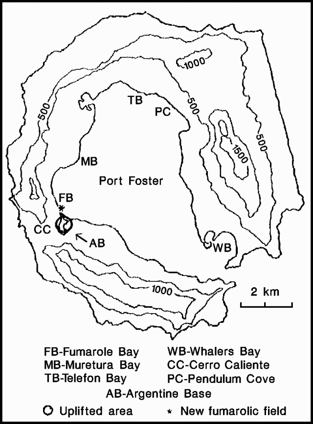 |
Figure 5. Sketch map of Deception Island, showing the area of uplift and new fumarole fields, early 1992. Courtesy of J. Viramonte. |
Continuous real-time monitoring is provided by a 3-component seismic station, LaCoste gravimeter, and magnetometer (all linked to a computer system) and a volcanological GPS geodetic net. Argentinian, Spanish, and British vessels are on alert in case of an eruption.
The last documented eruption of Deception Island, in 1970, was more violent than its predecessors in 1967 and 1969. Five maar-like submarine craters and seven land vents along an arcuate zone ~5 km long erupted mugearite tephra and built ~1.5 km2 of new land in the Telefon Bay area. The tephra blanket was salt-rich, suggesting involvement of substantial quantities of sea water (Shultz, 1972). Seismic data suggested that an eruption occurred in September 1972 and a plume was seen on a July 1987 satellite image but neither could be confirmed by ground observations.
Reference. Shultz, C.H., 1972, Eruption at Deception Island, Antarctica, August 1970: GSA Bulletin, v. 83, p. 2837-2842.
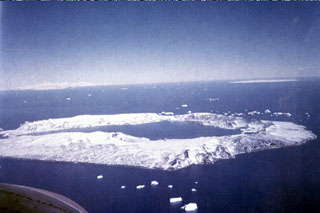
Geological Summary. Ring-shaped Deception Island, at the SW end of the South Shetland Islands, NE of Graham Land Peninsula, was constructed along the axis of the Bransfield Rift spreading center. A narrow passageway named Neptunes Bellows provides an entrance to a natural harbor within the 8.5 x 10 km caldera that was utilized as an Antarctic whaling station. Numerous vents along ring fractures circling the low 14-km-wide island have been reported active for more than 200 years. Maars line the shores of 190-m-deep Port Foster caldera bay. Among the largest of these maars is 1-km-wide Whalers Bay, at the entrance to the harbor. Eruptions during the past 8,700 years have been dated from ash layers in lake sediments on the Antarctic Peninsula and neighboring islands.
Information Contacts: R. Ortiz, Museo Nacional de Ciencias Naturales, Spain; C. Risso, Instituto Antártico Argentino; J. Viramonte, Univ Nacional de Salta, Argentina.