Report on Cerro Negro (Nicaragua) — March 1992
Bulletin of the Global Volcanism Network, vol. 17, no. 3 (March 1992)
Managing Editor: Lindsay McClelland.
Cerro Negro (Nicaragua) Strong Strombolian eruption with heavy ashfall and 28,000 evacuated
Please cite this report as:
Global Volcanism Program, 1992. Report on Cerro Negro (Nicaragua) (McClelland, L., ed.). Bulletin of the Global Volcanism Network, 17:3. Smithsonian Institution. https://doi.org/10.5479/si.GVP.BGVN199203-344070
Cerro Negro
Nicaragua
12.506°N, 86.702°W; summit elev. 728 m
All times are local (unless otherwise noted)
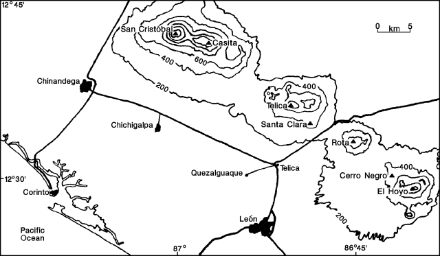
Violent Strombolian activity occurred at the volcano on 9-12 April, and resumed at lower intensity on 13-14 April. Heavy ashfall forced the evacuation of 28,000 people [but see BGVN 17:04] from nearby towns and from parts of León (18 km WSW; figure 3), the second-largest city in Nicaragua, between 10 and 12 April. No fatalities directly related to the eruption were reported, although there were two accidental deaths during the evacuation. The volcano was quiet as of 20 April.
9-12 April 1992. No instrumental seismic data were available before the eruption, but 5 earthquakes were felt in villages within 5 km of the volcano at about 2300 on 9 April, signalling the onset of activity. The first explosion occurred at 2320, and was quickly followed by the eruption of incandescent material with the development of a large ash cloud. The initial eruption plume rose an estimated 4000 m above the cone, and contained material up to bomb-size.
The ash cloud was visible on weather-satellite images beginning at 0000 on 10 April, and by 0530, the cloud extended 300 km to the WSW (264° azimuth), with a maximum width of about 200 km, at an estimated initial altitude of 6 km. Both ground and satellite observations indicated that the eruption was vigorous and nearly continuous. The eruption column, clearly visible from Managua (60 km SE) much of the time, was estimated from the ground to be approximately 7 km high. Satellite images showed that the plume extended 400 km W on 11-12 April. Material ejected to about 7.5 km during more energetic pulses of the eruption was carried roughly 50 km NE by higher-altitude winds. SO2 plumes that are significantly below the tropopause (roughly 16 km at this latitude) are difficult to detect with NASA's Total Ozone Mapping Spectrometer, and none were evident during the Cerro Negro eruption.
Ash began falling in León within 1 hour of the onset of activity, and formed deposits up to 4 cm thick by 1700 the next day. Very fine ashfall was reported as far away as the Pacific Coast (50 km W, in Corinto). Late on 10 April, the wind direction changed from WSW to W and ash accumulations were recognized in Telica (16 km W). That evening, 15 houses and several other structures, including a few large storage buildings, collapsed in León and surrounding areas. Collapses of numerous farm buildings, rural homes, and school buildings were reported over the next several days.
Ashfall continued W of the volcano, with accumulations of 2.5 cm of ash in Telica, 1.5 cm in Quezalguaque (20 km W), and 0.1 cm in Chinandega (50 km WNW) by 12 April. A change in wind direction to the SW during the night of 11 April caused the first ashfall S of León. That evening, incandescent material was observed consistently rising 300 m above the crater. Activity continued the following day, but was intermittent and less vigorous, finally ceasing at about 1800 on 12 April. During the 9-12 April activity, the crater diameter increased from approximately 100 m to 300-400 m.
13-14 April 1992. Only very light fumarolic activity was observed in the crater, and the volcano was otherwise quiet until explosions reportedly resumed around 2200-2300 on 13 April. An infrared satellite image at 2300 showed an already developed eruption cloud, which extended to about 350 km SSW by 0700 on 14 April. Remnants of the ash cloud produced by the more violent 9-12 April eruption were still evident 500 km W of the volcano on satellite images at 0800. Strombolian activity on 13-14 April ejected bombs to about 300 m height and produced a light ash cloud about 3.5 km high, but the interval between explosions (5 seconds early on 14 April), and their intensity, decreased throughout the day. The maximum recorded rate of ashfall in León, 2.4 gm/m2/minute, was measured at 1000. Although the plume appeared to be disconnected from the volcano on a satellite image at 1200, ground observations indicated that the eruption continued at lesser intensity until about 1730. Only light fumarolic activity was observed the following day.
Deposit thicknesses were 1 m, 1.2 km W; 15 cm, 13 km WSW; 5 cm, 20 km WSW; and 1 cm, 39 km WSW of the volcano. Rough calculations based on preliminary isopach mapping by INETER suggest a total erupted volume of approximately 0.03 km3 DRE.
Seismicity. Seismic stations were installed around the volcano on 10-11 April. During 10-12 April, low-frequency, low-amplitude seismic tremor was nearly continuous. Some B-type earthquakes were also recorded. The tremor rate declined on 12 April and tremor ceased on 13 April.
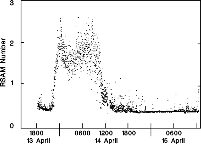
Several A-type events were recorded in the hours before the renewed eruption on 13 April. Tremor accompanied the eruption, and ceased at the end of explosive activity. Seismic data collected on 13-15 April (figure 4) show a very rapid rate of increase in seismic energy release immediately prior to the resumption of the eruption on the 13th, nearly steady-state energy release for the duration of the eruption, and a very rapid decrease to background levels following cessation of activity on the evening of the 14th. Geologists suggest that these data support the existence of a relatively open conduit that rapidly delivers magma from depth, and the current lack of any voluminous magma body close to the surface. On 17 April, 40 earthquakes were recorded near the volcano, a significant increase from seismicity on 15-16 April.
 |
Figure 4. Real-time Seismic Amplitude Measurements (RSAM) at Cerro Negro, 13-15 April 1992. Courtesy of C. Connor. |
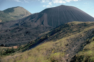
Geological Summary. Nicaragua's youngest volcano, Cerro Negro, was created following an eruption that began in April 1850 about 2 km NW of the summit of Las Pilas volcano. It is the largest, southernmost, and most recent of a group of four youthful cinder cones constructed along a NNW-SSE-trending line in the central Marrabios Range. Strombolian-to-subplinian eruptions at intervals of a few years to several decades have constructed a roughly 250-m-high basaltic cone and an associated lava field constrained by topography to extend primarily NE and SW. Cone and crater morphology have varied significantly during its short eruptive history. Although it lies in a relatively unpopulated area, occasional heavy ashfalls have damaged crops and buildings.
Information Contacts: Claudio Gutiérrez (Director); Helman Taleno L., Fabio Segura M., Martha Navarro C., Oscar Urbina L., and Wilfried Strauch, INETER, Aptdo. 2110, Managua, Nicaragua; Patricio Jerez, IRENA, Kilómetro 12, Carretera Norte, Managua, Nicaragua; C.B. Connor, FIU, Miami; J. Lynch, Thomas Baldwin, and Charles Kadin, SAB; S. Doiron, NASA GSFC; Deborah Jerez, 9808 Natick Rd., Burke, VA 22015 USA.


