Report on Cerro Negro (Nicaragua) — April 1992
Bulletin of the Global Volcanism Network, vol. 17, no. 4 (April 1992)
Managing Editor: Lindsay McClelland.
Cerro Negro (Nicaragua) Details of April tephra deposits and seismicity; changes to cone; feeder dike exposed
Please cite this report as:
Global Volcanism Program, 1992. Report on Cerro Negro (Nicaragua) (McClelland, L., ed.). Bulletin of the Global Volcanism Network, 17:4. Smithsonian Institution. https://doi.org/10.5479/si.GVP.BGVN199204-344070
Cerro Negro
Nicaragua
12.506°N, 86.702°W; summit elev. 728 m
All times are local (unless otherwise noted)
Ending 21 years of quiet, violent Strombolian explosions began at about 2320 on 9 April, shortly after 5 felt earthquakes (BGVN 17:03). The initial explosive phase produced a plume 7-7.5 km high, and deposited ash to the W and WSW (figure 5), before ceasing at about 1800 on 12 April. Between 6,000 and 9,000 people were evacuated (corrected from BGVN 17:03), and numerous houses and buildings collapsed under the weight of the accumulated ash. Reduced explosive activity (plumes to 3.5 km high) resumed at around 2200-2300 on 13 April, gradually decreasing until about 1730 on 14 April (figure 6), when all activity ceased.
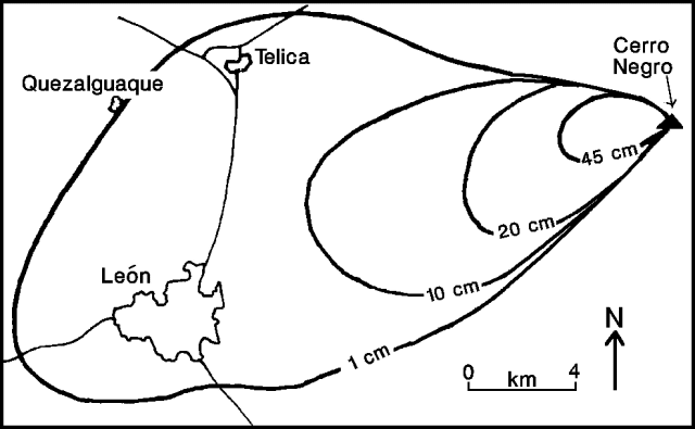 |
Figure 5. Preliminary isopach map of 9-14 April 1992 ashfall deposits from Cerro Negro. Prepared by INETER. |
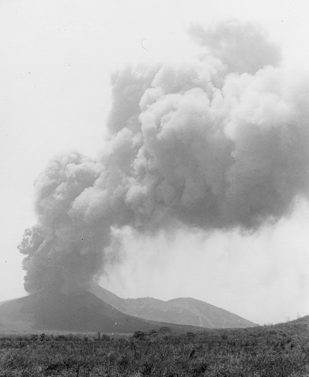 |
Figure 6. View of Cerro Negro's eruption from 4 km NW, 14 April 1992. Courtesy of G. Soto. |
Field observations, 13-14 April 1992. The volcano was visited by a team from the National Seismic Network (ICE-UCR) of Costa Rica, who operated two short-period portable seismometers on 13 and 14 April, 1 and 4 km from the crater. The following is from Gerardo Soto.
According to reports by residents near the volcano, the initial explosive activity on 9 April seemed to have been preceded by low-magnitude earthquakes. These occurred during the few minutes immediately preceding the explosion, and were only felt within 5 km of the volcano, neither causing damage nor alarming area residents. No seismic records exist for the period 9-12 April. During the 30 hours of seismic observations by the ICE-UCR team, periods of calm alternated with explosive activity. Observations can be summarized as follows: a) virtually no volcano-tectonic (A-type) seismicity was recorded; b) only a few small low-frequency events (durations <1 minute) and small tremor episodes were recorded during most of the quiet period before explosive activity resumed at 2200 on 13 April; c) a progressive increase in recorded tremor activity began at 2000 on 13 April, culminating in high-energy tremor completely saturating the record; d) continuous high-energy tremor was recorded during the roughly 19 hours of explosive activity that followed, with intermittent pulses of increased amplitude and energy (approximately 10 pulses/hour). Geologists interpreted the seismicity as indicating an open system, allowing the magma a direct and rapid ascent to the surface.
Tephra emitted during the eruption was carried predominantly W of the volcano, although very fine ash was reported at 13 km altitude over northern Nicaragua, probably carried by high-altitude winds from the Pacific Ocean. Two granulometric analyses were conducted: 1) ash collected on 13 April, 0.5 km NW of the crater, on Cerro La Mula; and 2) ash collected on 14 April, 21 km along the axis of dispersal, in León (table 1). The ejected ballistic tephra were abundant within 0.5 km of the crater, and less common to 1 km radius. Shrubs were severely damaged within this area. The ballistic clasts are gray-black porphyritic olivine basalts, with phenocrysts of plagioclase (about 30%), olivine (about 5%), and pyroxene (about 1%). Scoriae are black and strongly vesiculated, whereas the gray cognate blocks are poorly vesiculated. The fine ash deposited along the axis of dispersal was rich in millimeter-sized glassy scoria fragments, and isolated crystals of plagioclase and olivine.
Table 1. Granulometric analyses of April 1992 bulk airfall deposit samples from Cerro Negro, collected on 13 April 1992 at Cerro la Mula (0.5 km NW of the crater, and on 14 April at León (21 km SW of the crater). * indicates that the largest clast was smaller than 2.0 mm. Courtesy of ICE-UCR.
| Size (mm) | Cerro la Mula sample % | Cerro la Mula cumulative % | León sample % | León cumulative % |
| 16-8 | 9.9 | 9.9 | -- | -- |
| 8-4 | 22.8 | 32.7 | -- | -- |
| 4-2.38 | 26.5 | 59.2 | -- | -- |
| 2.38-1.19 | 27.9 | 87.1 | 1.2* | 1.2* |
| 1.19-0.6 | 9.1 | 96.2 | 4.5 | 5.7 |
| 0.6-0.3 | 2.5 | 98.7 | 48.8 | 54.5 |
| 0.3-0.15 | 0.9 | 99.6 | 36.4 | 90.9 |
| 0.15-0.075 | 0.5 | 100.1 | 4.5 | 95.4 |
| less than 0.075 | 0.0 | 100.1 | 4.5 | 99.9 |
During the first three days of the eruption, government officials reported severe damage from ashfall over an area of about 186 km2, of which about 116 km2 are corn, cotton, sesame, beans, and other grain cultivation, and 70 km2 are sugar cane. In addition, numerous cattle were affected. The most severe damage extended from the volcano to the city of León. Primary damage to home, commercial, and industrial infrastructure, estimated at $3,000,000, was mostly caused by roof collapse on the first day of the eruption. As of 15 April, there were no reports of injuries directly related to the eruption. The 50 indirectly related injuries occurred predominantly during evacuations, and from falls as people cleaned their roofs; 1-2 people died from falls. The primary medical complaints were eye and respiratory problems. Refugees were evacuated to 4 centers distant from the most affected area.
Field observations, 23-29 April. The following, from S. Williams, describes fieldwork during 23-29 April.
A rusty brown plume was emanating from the region close to Cerro Negro during the approach to Managua on 23 April. The plume reached 1-2 km, extending W to >100 km, causing the pilot to detour W, far out to sea, to avoid it. During a 1 1/2 hour visit later that day to a site about 3 km SW of the crater, there was no visible gas emission, noise, landslides, or felt seismicity, suggesting that the plume consisted entirely of re-suspended fine ash from the regional tephra blanket. COSPEC measurements from the same site the next day yielded a barely discernible SO2 signal; calculations suggested a maximum SO2 flux of <25 metric tons/day (t/d). Again, there were no visible signs of activity from the volcano.
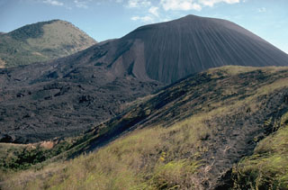
On 28 April, the summit was clear for 40 minutes during a helicopter overflight. The crater appeared to be very quiet, with 3 main regions of low-pressure degassing, occupying essentially the same sites known from before the 1992 eruption. The crater was estimated to have widened somewhat, to at least 300 m in diameter (but had not tripled in width as indicated in BGVN 17:03), and was about 2x deeper than formerly. The inner-crater walls were extremely steep (about 60° in places) and cut outward-dipping tephra beds of the old cone. In the lower portion of the crater, a large dike was plainly visible. Concentrations of large boulders (>2 m in diameter) were scattered at the E base of the cone, apparently after being ejected beyond the crater rim during the eruption and rolling down the cone's outer slopes.
The distribution and impact of the ash blanket were visible when flying over León. The collapsed structures tended to be public (e.g. schools) or large businesses (e.g. cotton warehouses) and apparently represented the failure to clean accumulated scoriae and ash from their roofs. León was still the site of major cleanup efforts; most households removed all of their clay roof tiles, cleaned them and replaced them. There appeared to be only minor danger of mudflow activity, reflecting the low topographic relief of the area, the fact that no major drainage begins on Cerro Negro and continues through León, and the relatively thin deposits (about 3 cm in León). Selected drainages were to be cleaned out, for fear that even small mudflows might damage bridges on the Pan American highway.
The crater was visited on 29 April by a group of Nicaraguan, American, and Russian scientists. A fault circled virtually the entire crater rim, with vertical and horizontal offset of ~25 cm. The fault was the site of minor degassing and fumarole sublimate deposition; maximum gas temperature was 189°C. The very steep slopes and nearly complete fault suggested that the crater will undergo massive slumping, probably after the first rains soak the scoriae, and will resume its more typical broad, shallow, bowl-like form. The rim was notably more uneven than the pre-1992 rim, reflecting heavy accumulation of scoriae on the W margin; the low point on the rim was about 675 m, and the high point might have reached 850 m. No agglutinate was found anywhere in the crater or on the rim.
A descent was made to the principal accessible fumarole field, adjacent to the dike on the SW side of the crater. The dike was oriented at 290° and extended intermittently across the crater, becoming more pipe-like (~6 m in diameter) at the center, where it appeared to represent the primary eruptive conduit. All of the remaining degassing occurred along the dike, centered on a small zone about 10 m long on its SE portion, at the central pipe, and on its NW portion. The maximum measured temperature was 350° and abundant sublimate deposition was evident (possibly thenardite). Degassing was quite diffuse and passive, and the overall appearance was remarkably like that seen in a previous visit in 1982. There was a strong smell of HCl, with notable SO2 odor but no H2S.
Geological Summary. Nicaragua's youngest volcano, Cerro Negro, was created following an eruption that began in April 1850 about 2 km NW of the summit of Las Pilas volcano. It is the largest, southernmost, and most recent of a group of four youthful cinder cones constructed along a NNW-SSE-trending line in the central Marrabios Range. Strombolian-to-subplinian eruptions at intervals of a few years to several decades have constructed a roughly 250-m-high basaltic cone and an associated lava field constrained by topography to extend primarily NE and SW. Cone and crater morphology have varied significantly during its short eruptive history. Although it lies in a relatively unpopulated area, occasional heavy ashfalls have damaged crops and buildings.
Information Contacts: G.J. Soto and R. Barquero, ICE; Sergio Paniagua and Hector Flores, Sección de Sismología, Vulcanología y Exploración Geofísica, Escuela Centroamericana de Geología, Univ de Costa Rica, Apdo. 35 UCR, San José, Costa Rica; S. Williams, Arizona State Univ; Martha Navarro C. and Silvia Arguello G., INETER, Apdo. 2110, Managua, Nicaragua; Josephine Malilay, Health Studies Branch, F-28, Centers for Disease Control, 1600 Clifton Road, N.E., Atlanta, GA 30333 USA.