Report on Deception Island (Antarctica) — April 1992
Bulletin of the Global Volcanism Network, vol. 17, no. 4 (April 1992)
Managing Editor: Lindsay McClelland.
Deception Island (Antarctica) Increased seismicity and thermal activity; uplift
Please cite this report as:
Global Volcanism Program, 1992. Report on Deception Island (Antarctica) (McClelland, L., ed.). Bulletin of the Global Volcanism Network, 17:4. Smithsonian Institution. https://doi.org/10.5479/si.GVP.BGVN199204-390030
Deception Island
Antarctica
62.9567°S, 60.6367°W; summit elev. 602 m
All times are local (unless otherwise noted)
Seismicity was more vigorous during the 1991-92 austral summer than in previous years and was associated with increased fumarolic activity, gravity changes, and deformation. The following supplements the report in 17:1.
Seismic monitoring, with similar instruments at the same locations as in previous years, yielded 766 events between 21 December 1991 and 23 February 1992, many in clusters lasting up to several days (figure 6 and table 1). The most vigorous activity occurred around 10 January and in late January/early February. More than half of the recorded events were followed by another with similar characteristics within an hour. Most had magnitudes of 0.8-2. Of the 15 shocks exceeding this range, four were felt, all were M >3, and all were within 100 km of the station at the Argentine base. RSAM data (figure 6) show both individual events and swarms, but geologists did not believe that the observed acceleration was large enough to suggest that an eruption was imminent.
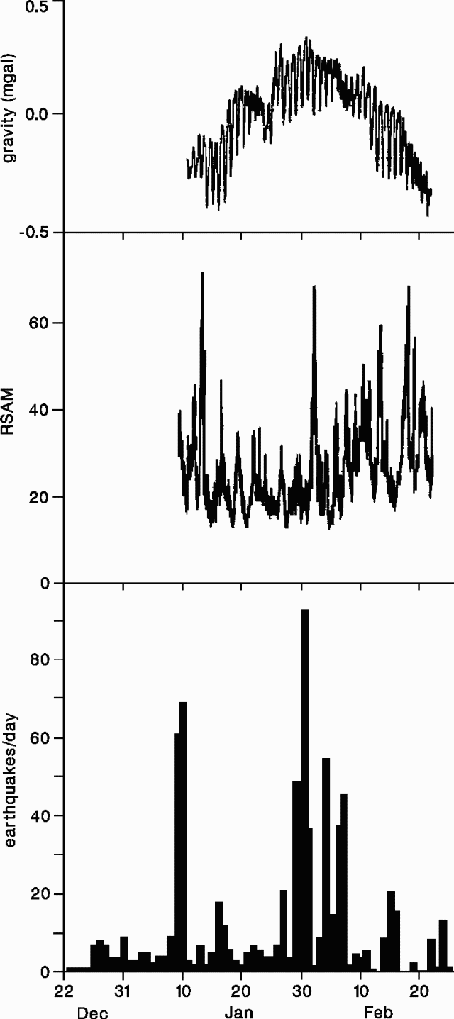 |
Figure 6. Gravity data (top), Real-time Seismic Amplitude Measurements (RSAM) (middle), and the number of seismic events per day (bottom) recorded at Deception Island, 22 December 1991-24 February 1992. Gravity data are compensated for instrument deflection, which consistently indicated uplift in the direction of Cerro Caliente. Courtesy of Ramón Ortiz. |
Table 1. Summary of increased seismic activity at Deception Island, December 1991-February 1992.
| Date | Observations |
| 27 Dec 1991 | Felt seismic event (M 3.2). |
| 31 Dec 1991 | Seismic crisis preceded by an earthquake with an anomalous high-frequency phase; 3 hours of tremor recorded; local seismic activity reported the next day. |
| 04 Jan 1992 | Felt seismic event (M 3.4). |
| 09-10 Jan 1992 | Cluster of >150 low-frequency (B-type) and some A-type events occurred very close to the station, probably associated with an increase in fumarolic activity. Steam emission increased in areas with hot soils; a few hours after the seismic crisis ended, the beach between the fumaroles and the hot soils area was covered by a mass of dead krill. |
| 11 Jan 1992 | Significant regional earthquake but less local activity (A-type events). |
| 18-19 Jan 1992 | Seismic crisis began with tremor and discrete events, accompanied by small irregularities in earth tides (the first swarm during which earth tide and RSAM data were available). At about 0000 on 19 January, the gravimeter showed a sudden variation in the deflection rate, while seismic activity rapidly decreased. After a slight resumption in seismicity, a small (M 1.6) earthquake took place, then the anomalous gravimetric deflection stopped (figure 7). Another large krill mortality was associated with this episode. |
| 25 Jan 1992 | Felt seismic event (M 3.3). |
| 30 Jan 1992 | Frequent B-type events. |
| 04 Feb 1992 | Frequent tremor and B-type events. |
| 16 Feb 1992 | About 4 hours of frequent tremor episodes, each lasting 10-20 minutes, separated by quiet periods of similar duration. Great quantities of dead krill, but only around fumaroles. |
| 22 Feb 1992 | Felt seismic event (M 2.1), with elevated high- frequency content; small tremor episodes |
| 25 Feb 1992 | Tremor felt for about 2 minutes; small seismic events. |
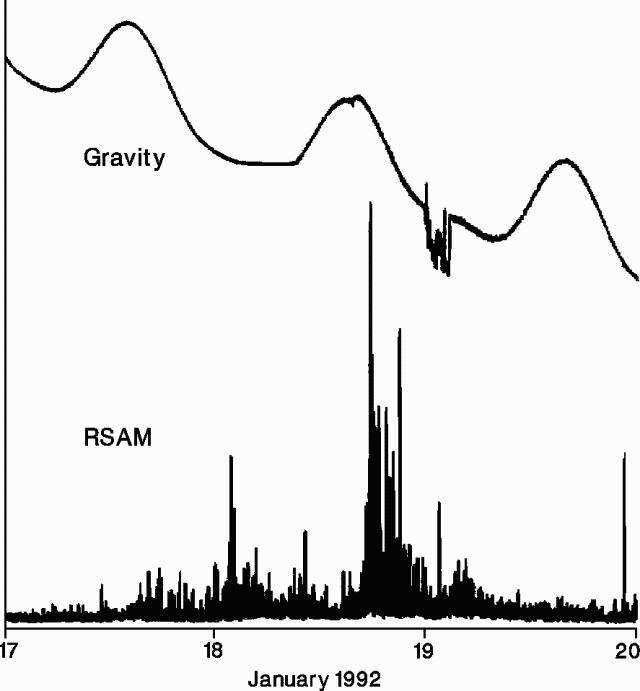 |
Figure 7. Gravity data (top) and Real-time Seismic Amplitude Measurements (bottom) recorded at Deception Island, 17-19 January 1992, showing the anomalous gravitmetric deflection associated with the 18-19 January swarm. Courtesy of Ramón Ortiz. |
Gravity data showed an increase until after the 30 January seismic crisis, then a decrease until the end of monitoring on 22 February (figure 6). Small gravity irregularities corresponded with successive seismic swarms. Compensations in the gravity data were required to allow for deflections that indicated uplift toward Cerro Caliente (figure 8), the area identified as the center of renewed activity. Uplift was visible in the nearby Fumarole Bay area and in the vicinity of the Argentine station, where the helicopter landing field was noticeably tilted. Uplift totaled ~20 cm in the past year.
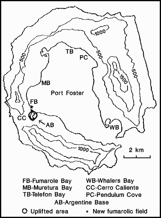 |
Figure 8. Sketch map of Deception Island, showing the area of recent uplift and new fumaroles, early 1992. Courtesy of José Viramonte. |
The area of hot soil near Fumarole Bay and Cerro Caliente appeared to be larger than in previous years. Fumarolic emission from the top of Cerro Caliente had increased noticeably, as had the concentration of sulfur compounds in Fumarole Bay. Some of the seismic swarms were associated with deaths of krill (small shrimp-like marine organisms) near fumarolic areas.
Geologists noted that the activity . . . could be related to a magmatic intrusion in the main fracture system of the Fumarole Bay area. No acceleration in any of the measured parameters (uplift, earth tides, seismicity, magnetic field, and temperature) was evident, so an eruption was not thought to be imminent. However, the possibility of a small phreatic eruption from the hot area on the beach near Cerro Caliente could not be ruled out. Because the Argentine station is near the potentially active area, an evacuation camp was established in a valley almost 4 km E of Cerro Caliente (in the Crater Lake area) and separated from it by highlands. The valley rises from 15 to 50 m elevation (offering tsunami protection), glaciers are poorly developed above the valley (reducing the risk of lahars), the terrain allows easy helicopter operation, and easily traveled routes lead to the inner coast for possible evacuation by sea.
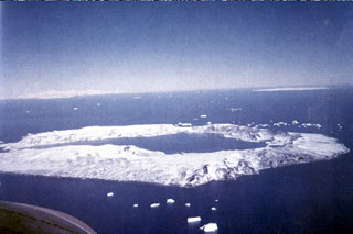
Geological Summary. Ring-shaped Deception Island, at the SW end of the South Shetland Islands, NE of Graham Land Peninsula, was constructed along the axis of the Bransfield Rift spreading center. A narrow passageway named Neptunes Bellows provides an entrance to a natural harbor within the 8.5 x 10 km caldera that was utilized as an Antarctic whaling station. Numerous vents along ring fractures circling the low 14-km-wide island have been reported active for more than 200 years. Maars line the shores of 190-m-deep Port Foster caldera bay. Among the largest of these maars is 1-km-wide Whalers Bay, at the entrance to the harbor. Eruptions during the past 8,700 years have been dated from ash layers in lake sediments on the Antarctic Peninsula and neighboring islands.
Information Contacts: A. García and R. Ortiz, Museo Nacional de Ciencias Naturales, Spain; C. Risso, Instituto Antártico Argentino; J. Viramonte, Univ Nacional de Salta, Argentina.