Report on Antuco (Chile) — May 1992
Bulletin of the Global Volcanism Network, vol. 17, no. 5 (May 1992)
Managing Editor: Lindsay McClelland.
Antuco (Chile) Fumarolic activity in summit crater's small scoria cone
Please cite this report as:
Global Volcanism Program, 1992. Report on Antuco (Chile) (McClelland, L., ed.). Bulletin of the Global Volcanism Network, 17:5. Smithsonian Institution. https://doi.org/10.5479/si.GVP.BGVN199205-357080
Antuco
Chile
37.406°S, 71.349°W; summit elev. 2979 m
All times are local (unless otherwise noted)
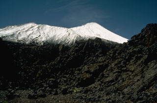
During a February overflight, fumarolic activity was visible in the small scoria cone nested within the main crater. Weak summit fumaroles had previously been observed during visits in 1969, 1982, and March 1984. Fumarolic activity has apparently been continuous, but of variable intensity, from the cone since the volcano's last eruption in 1869. Lava flows from Antuco dammed Laja Lake's outlet in 1853, causing the water level to rise around 20 m.
Geological Summary. Antuco volcano, constructed NE of the Pleistocene Sierra Velluda stratovolcano, rises dramatically above the SW shore of Laguna de la Laja. It has a complicated history beginning with construction of the basaltic-to-andesitic Sierra Velluda and Cerro Condor stratovolcanoes of Pliocene-Pleistocene age. Construction of the Antuco I volcano was followed by edifice failure at the beginning of the Holocene that produced a large debris avalanche which traveled down the Río Laja to the west and left a large 5-km-wide caldera breached to the west. The steep-sided modern basaltic-to-andesitic cone has grown 1,000 m since then; flank fissures and cones have also been active. Moderate explosive eruptions were recorded in the 18th and 19th centuries from both summit and flank vents, and lava flows have traveled into the Río Laja drainage.
Information Contacts: H. Moreno, SAVO, Temuco.