Report on Erta Ale (Ethiopia) — November 1992
Bulletin of the Global Volcanism Network, vol. 17, no. 11 (November 1992)
Managing Editor: Lindsay McClelland.
Erta Ale (Ethiopia) Lava lake active in S crater during first fieldwork in many years
Please cite this report as:
Global Volcanism Program, 1992. Report on Erta Ale (Ethiopia) (McClelland, L., ed.). Bulletin of the Global Volcanism Network, 17:11. Smithsonian Institution. https://doi.org/10.5479/si.GVP.BGVN199211-221080
Erta Ale
Ethiopia
13.601°N, 40.666°E; summit elev. 585 m
All times are local (unless otherwise noted)
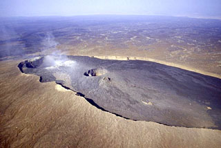
Geologists climbed to the summit . . . on 10-11 November, for the first time in many years. Members of the group made the first known descent into the active S crater . . . (figure 4). The active pit-crater was >100 m in diameter, with vertical walls and a lava lake at 100 m depth (figure 5). A winch and ropes were used to descend the E wall on the morning of 11 November for a 2-hour visit. The 40 x 70 m lava lake occupied the W part of the crater. Air temperature at the bottom of the crater was 35°C, ~5°C cooler than the ambient temperature at the rim. Wearing gas masks, geologists approached to within 2 m of the lava lake. The lake was continuously active with 4-5-m-high lava fountains in four locations and rapid motion of the lake surface outward from the center. The N crater was confirmed to be inactive, with the bottom full of fallen rock, although there were two strong fumaroles on the S rim.
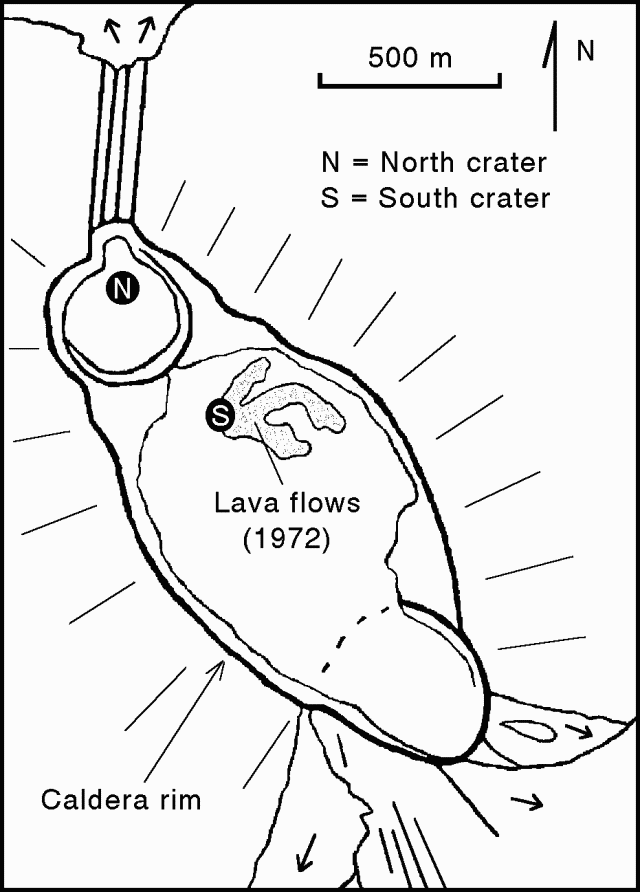 |
Figure 4. Summit caldera of Erta Ale, April 1972, showing the N and S craters. Lava spillways over the caldera rim are shown diagrammatically. Sketch by Jacques Varet. |
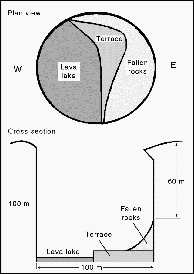 |
Figure 5. Diagrammatic plan view (top) and cross-section (bottom) of the active S crater at Erta Ale, November 1992. Courtesy of P. Vetsch. |
Geological Summary. The Erta Ale basaltic shield volcano in Ethiopia has a 50-km-wide edifice that rises more than 600 m from below sea level in the Danakil depression. The volcano includes a 0.7 x 1.6 km summit crater hosting steep-sided pit craters. Another larger 1.8 x 3.1 km wide depression elongated parallel to the trend of the Erta Ale range is located SE of the summit and is bounded by curvilinear fault scarps on the SE side. Basaltic lava flows from these fissures have poured into the caldera and locally overflowed its rim. The summit caldera usually also holds at least one long-term lava lake that has been active since at least 1967, and possibly since 1906. Recent fissure eruptions have occurred on the N flank.
Information Contacts: P. Vetsch, M. Vigny, and A. Schussele, SVG, Switzerland; L. Cantamessa, Géo-découverte, Switzerland; G. Pareau, Assoc of Alpine Guides of Chamonix, France; P. Villemin and A. Curvelier, Gaumont Television, Paris, France.