Report on Karangetang (Indonesia) — December 1992
Bulletin of the Global Volcanism Network, vol. 17, no. 12 (December 1992)
Managing Editor: Lindsay McClelland.
Karangetang (Indonesia) Ash ejection and hot lahars force evacuations
Please cite this report as:
Global Volcanism Program, 1992. Report on Karangetang (Indonesia) (McClelland, L., ed.). Bulletin of the Global Volcanism Network, 17:12. Smithsonian Institution. https://doi.org/10.5479/si.GVP.BGVN199212-267020
Karangetang
Indonesia
2.781°N, 125.407°E; summit elev. 1797 m
All times are local (unless otherwise noted)
Activity began on 21 January [1993], when a hot mudflow was observed at 1714 flowing S along the Bahembang River to 4.5 km from the summit. The eruption of hot mud and ash forced the evacuation of 452 people. No casualties had been reported by 25 January, but a bridge linking the villages of Dame and Karanglung, ~4 km SSW, was destroyed by hot ashes. Ashfall was also reported 3-6 km SE and SSE of the summit (in the villages of Bubali, Salili, Panili, and Ondang). Official lahar warnings were issued in November after heavy rainfall on the S flank of the volcano . . . .
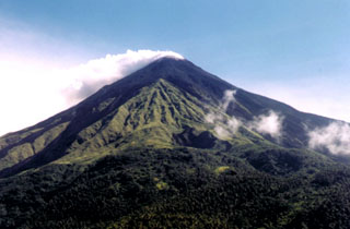
Geological Summary. Karangetang (Api Siau) volcano lies at the northern end of the island of Siau, about 125 km NNE of the NE-most point of Sulawesi. The stratovolcano contains five summit craters along a N-S line. It is one of Indonesia's most active volcanoes, with more than 40 eruptions recorded since 1675 and many additional small eruptions that were not documented (Neumann van Padang, 1951). Twentieth-century eruptions have included frequent explosive activity sometimes accompanied by pyroclastic flows and lahars. Lava dome growth has occurred in the summit craters; collapse of lava flow fronts have produced pyroclastic flows.
Information Contacts: ANS.

