Report on Moyorodake [Medvezhia] (Japan - administered by Russia) — December 1992
Bulletin of the Global Volcanism Network, vol. 17, no. 12 (December 1992)
Managing Editor: Lindsay McClelland.
Moyorodake [Medvezhia] (Japan - administered by Russia) Intense fumarolic activity
Please cite this report as:
Global Volcanism Program, 1992. Report on Moyorodake [Medvezhia] (Japan - administered by Russia) (McClelland, L., ed.). Bulletin of the Global Volcanism Network, 17:12. Smithsonian Institution. https://doi.org/10.5479/si.GVP.BGVN199212-290100
Moyorodake [Medvezhia]
Japan - administered by Russia
45.389°N, 148.838°E; summit elev. 1124 m
All times are local (unless otherwise noted)
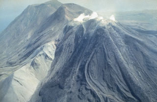
Fumarolic activity was intense during fieldwork in late 1992. The maximum fumarole temperature measured August-October 1992 was 910°C (figure 1), and rocks at 20-30 cm depth glowed red. CO2-rich gases were sampled in August 1990 (table 1).
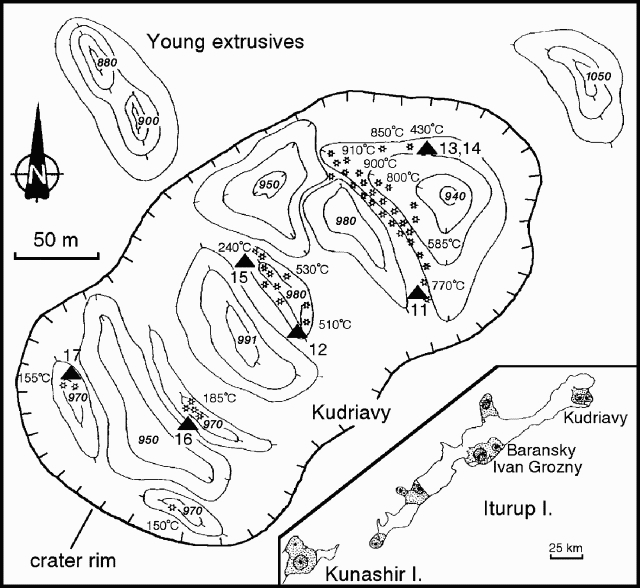 |
Figure 1. Sketch map of the summit area of the Kudriavy cone at Medvezhia, showing fumarole temperatures and elevations of some thermal features, August-October 1992. Contour interval is 10 m. Triangles mark collection sites for gas samples. The inset map shows Iturup Island, with locations of Kudriavy, Baransky, and Ivan Grozny volcanoes, plus the NE corner of neighboring Kunashir Island. Courtesy of G. Steinberg. |
Table 1. Fumarole temperatures, mole percent H2O, and volume percent of dry gas species from Kudriavy, August 1990. Data does not include N2, O2, or Ar. Sample localities are shown on figure 1. Analyses by U.A. Taran and U.A. Ignatorich. Data courtesy of G. Steinberg.
| Sample | 11 | 12 | 13 | 14 | 15 | 16 | 17 |
| Temp. (°C) | 770 | 511 | 430 | 430 | 240 | 160 | 156 |
| H2O (mole %) | 96.0 | 96.1 | 96.7 | 95.6 | 96.4 | 81.5 | 78.8 |
| CO2 | 63.78 | 78.28 | 40.57 | 41.61 | 82.25 | 83.28 | 83.51 |
| H2S | 6.67 | 11.06 | 27.80 | 28.50 | 5.35 | 8.50 | 10.48 |
| SO2 | 13.44 | 5.06 | 9.77 | 9.50 | 6.38 | 3.19 | 4.02 |
| H2 | 8.98 | 1.56 | 8.53 | 8.33 | 0.08 | 0.23 | 0.15 |
| HCl | 6.52 | 4.00 | 13.11 | 11.30 | 2.52 | 0.06 | 1.17 |
| HF | 0.40 | -- | 0.69 | 0.65 | 0.29 | 0.01 | 0.15 |
| CO | 0.19 | 0.01 | 0.035 | 0.060 | 0 | 0 | 0 |
| CH4 | 0 | 0.007 | 0.14 | 0.04 | 0.18 | 0.014 | 0.013 |
Geological Summary. The Moyorodake volcanic complex (also known as Medvezhia) occupies the NE end of Iturup (Etorofu) Island. Two overlapping calderas, 14 x 18 and 10 x 12 km in diameter, were formed during the Pleistocene. The caldera floor contains several lava domes, cinder cones and associated lava fields, and a small lake. Four small closely spaced stratovolcanoes were constructed along an E-W line on the eastern side of the complex. The easternmost and highest, Medvezhii, lies outside the western caldera, along the Pacific coast. Srednii, Tukap, and Kudriavy (Moyorodake) volcanoes lie immediately to the west. Historically active Moyorodake is younger than 2000 years; it and Tukap remain fumarolically active. The westernmost of the post-caldera cones, Menshoi Brat, is a large lava dome with flank scoria cones, one of which has produced a series of young lava flows up to 4.5 km long that reached Slavnoe Lake. Eruptions have been documented since the 18th century, although lava flows from cinder cones on the flanks of Menshoi Brat were also probably erupted within the past few centuries.
Information Contacts: G. Steinberg, Yuzhno-Sakhalinsk.