Report on Unzendake (Japan) — May 1993

Bulletin of the Global Volcanism Network, vol. 18, no. 5 (May 1993)
Managing Editor: Edward Venzke.
Unzendake (Japan) Exogenous growth of lava dome complex; pyroclastic flows destroy houses
Please cite this report as:
Global Volcanism Program, 1993. Report on Unzendake (Japan) (Venzke, E., ed.). Bulletin of the Global Volcanism Network, 18:5. Smithsonian Institution. https://doi.org/10.5479/si.GVP.BGVN199305-282100
Unzendake
Japan
32.761°N, 130.299°E; summit elev. 1483 m
All times are local (unless otherwise noted)
Exogenous growth of lava dome 11 and frequent pyroclastic flows characterized the period from mid-April to mid-May. Dome 11 grew every day, covering parts of dome 4 (figure 56). When dome 11 was first observed, on 17 March, the surrounding topography was too steep for flowage of viscous lava. Instead, the growing dome collapsed repeatedly, eventually producing a gentle slope that the lava could flow down. Theodolite measurements revealed a 10-20 m subsidence of the vent site. In early June, dome 11 was ~ 360 m wide, 340 m long, and 30-80 m thick. This dome is now probably as large as dome 4, which reached a length of ~ 400 m, and was the largest dome of this eruption. Viscous lava flowed from the vent site to create a large ramp structure. Growth was continuing through mid-June. Volcanic tremor was almost absent during this period of continuous growth.
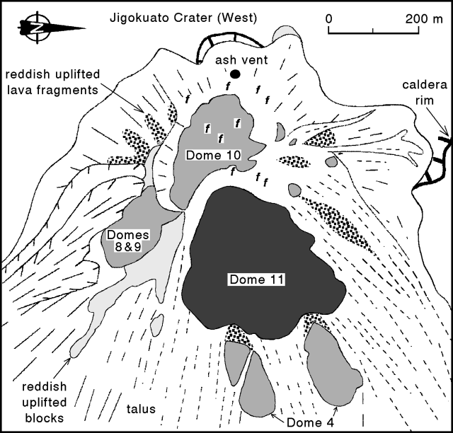 |
Figure 56. Sketch map of the lava dome complex at Unzen, early June 1993. Large solid dot is ash vent, "f" indicates fumarole locations. Note that N is to the right. Courtesy of Setsuya Nakada. |
Collapses from dome 11 generated pyroclastic flows NE down the Nakao River starting on 21 May. Five pyroclastic flows traveled about 3 km, reaching residential areas of Senbongi District 21-24 May. On the evening of 23 May, one pyroclastic flow stopped near the abandoned houses destroyed by the April-May debris flows after following the same course. There were 281 seismically detected pyroclastic flows in May . . . . The longest pyroclastic flow of May traveled 3.5 km E down the Mizunashi River and had a seismic duration of 150 seconds. Ash clouds from the pyroclastic flows rose about 1-2 km, generally higher than previous months. Pyroclastic surges associated with these debris flows extended only tens of meters beyond the river's edge. The volume of the pyroclastic flow was estimated to be ~ 2 x 10⁵ m3. It caused no damage.
Volcanic gas emissions continued from around dome 10 . . . . An ash-laden plume was emitted on 2 June from a re-opened vent in the crater (figure 56). Plumes had not been observed since February, when all of the former vents were covered by talus from dome 10. COSPEC measurements in mid-May by the Kusatsu-Shirane Volcano Observatory, Tokyo Institute of Technology, showed an SO2 flux of 100-300 t/d, with an average of 200 t/d. Values in December and February were < 100 t/d; the maximum since 1990 was about 350 t/d.
SiO2 content of the dome 11 lavas is ~ 64.0-64.5 wt. %, close to the values for the 1991 to mid-1992 lavas (64.5-65.5%). Lava erupted from late 1992 to early 1993 was significantly less silicic (down to 63.5% SiO2). The magma-supply rate for the period mid-April to mid-May was ~ 1-2 x 10⁵ m3/day.
Seismicity at the dome complex was above normal 14-28 May, but was not correlated with any significant changes in dome features. Based on locations of the events, the increase may have been caused by the northward growth of dome 11. A total of 3,037 microearthquakes was recorded in May, a large increase from 656 in April.
The mayor of Shimabara enlarged the evacuated area 24 May because of the pyroclastic-flow activity, increasing the number of evacuees from 2,008 to 2,336. This number was reduced on 26 May to 2,132 when areas along the Mizunashi River 5 km E of the dome complex were reoccupied.
Similar activity continued through mid-June. Debris flows triggered by heavy rainfall buried roads on 2 and 13 June, causing temporary evacuation of ~ 5,000 residents. There were 25 pyroclastic flows counted on 13 June, the largest daily total since 29 April. Press reports indicate that early on 23 June, two pyroclastic flows traveled ~ 4.5 km down the Nakao River, destroying an estimated 50 buildings and killing one man.
Geological Summary. The massive Unzendake volcanic complex comprises much of the Shimabara Peninsula east of the city of Nagasaki. An E-W graben, 30-40 km long, extends across the peninsula. Three large stratovolcanoes with complex structures, Kinugasa on the north, Fugen-dake at the east-center, and Kusenbu on the south, form topographic highs on the broad peninsula. Fugendake and Mayuyama volcanoes in the east-central portion of the andesitic-to-dacitic volcanic complex have been active during the Holocene. The Mayuyama lava dome complex, located along the eastern coast west of Shimabara City, formed about 4000 years ago and was the source of a devastating 1792 CE debris avalanche and tsunami. Historical eruptive activity has been restricted to the summit and flanks of Fugendake. The latest activity during 1990-95 formed a lava dome at the summit, accompanied by pyroclastic flows that caused fatalities and damaged populated areas near Shimabara City.
Information Contacts: JMA; S. Nakada, Kyushu Univ; AP.