Report on Popocatepetl (Mexico) — June 1993

Bulletin of the Global Volcanism Network, vol. 18, no. 6 (June 1993)
Managing Editor: Edward Venzke.
Popocatepetl (Mexico) Increased fumarolic activity in January; crater description
Please cite this report as:
Global Volcanism Program, 1993. Report on Popocatepetl (Mexico) (Venzke, E., ed.). Bulletin of the Global Volcanism Network, 18:6. Smithsonian Institution. https://doi.org/10.5479/si.GVP.BGVN199306-341090
Popocatepetl
Mexico
19.023°N, 98.622°W; summit elev. 5393 m
All times are local (unless otherwise noted)
The following is a report by Hugo Delgado Granados of a visit to the crater 3 January 1993. Delgado has ascended the summit of Popocatépetl more than 50 times in the last two decades.
"Popocatépetl was climbed after several witnesses from towns around the volcano reported an increase of fumarolic activity from the crater. The ascent was made in clear weather, with the summit reached by noon. Fumaroles are much larger and in greater concentrations than on previous visits. Emissions are now visible from Tlamacas (4 km NW at 4,000 m elevation), as well as from Puebla (50 km E) and Cuautla (40 km S), depending on atmospheric conditions. During the last 10 years, slightly whitish emissions emerging through the lower crater rim to the NE were commonly observed in the morning. However, recent emissions have risen higher and are very dense with a yellow-green color.
"The crater is elliptical-cylindrical in shape, with a major axis of 850 m and a minor axis of 650 m (figure 1). There is a 460 m elevation difference between the main summit and the bottom of the crater (230 m below the lower crater rim). The shortest way into the crater is to rappel from a 70 m overhang on the lower crater rim; the remaining 160 m consists of a steep rocky slope that can be walked down. In the NE part of the main crater are the remnants of a former lava dome, 195 m in diameter and 50-70 m high, which was partly destroyed during the 1919-27 eruption, leaving a smaller inner crater. That crater contains an intermittent crater lake, acidic and greenish in color, at 4,955 m elevation.
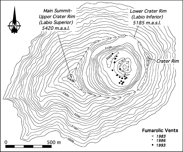 |
Figure 1. Topographic map of the summit area and crater of Popocatépetl, showing the crater rim and locations of fumaroles in 1983, 1986, and 1993. Courtesy of Hugo Delgado Granados, UNAM. |
"The locations of fumarolic vents observed in 1983, 1986, and 1993 are shown in figure 1. It is evident that the vents observed in 1993 are more numerous than in previous years. Gas emissions in 1983 and 1986 were whitish, suggesting a predominance of water vapor, and the plumes rose slowly. The 1993 fumarole emissions are more powerful (noises can be heard from the crater rim), denser, and more yellowish-green than before. Dense plumes from these fumaroles rise to the crater rim before being dispersed by the wind. Additional evidence of a higher sulfur content in the fumarole emissions is the widespread yellow coloration of snow around the crater rim and zones where sulfur is being precipitated on the crater floor."
Geological Summary. Volcán Popocatépetl, whose name is the Aztec word for smoking mountain, rises 70 km SE of Mexico City to form North America's 2nd-highest volcano. The glacier-clad stratovolcano contains a steep-walled, 400 x 600 m wide crater. The generally symmetrical volcano is modified by the sharp-peaked Ventorrillo on the NW, a remnant of an earlier volcano. At least three previous major cones were destroyed by gravitational failure during the Pleistocene, producing massive debris-avalanche deposits covering broad areas to the south. The modern volcano was constructed south of the late-Pleistocene to Holocene El Fraile cone. Three major Plinian eruptions, the most recent of which took place about 800 CE, have occurred since the mid-Holocene, accompanied by pyroclastic flows and voluminous lahars that swept basins below the volcano. Frequent historical eruptions, first recorded in Aztec codices, have occurred since Pre-Columbian time.
Information Contacts: Hugo Delgado Granados, Instituto de Geofísica, UNAM.