Report on Merapi (Indonesia) — January 1994

Bulletin of the Global Volcanism Network, vol. 19, no. 1 (January 1994)
Managing Editor: Richard Wunderman.
Merapi (Indonesia) Avalanches decrease; and seismic spectra for tremor and avalanches
Please cite this report as:
Global Volcanism Program, 1994. Report on Merapi (Indonesia) (Wunderman, R., ed.). Bulletin of the Global Volcanism Network, 19:1. Smithsonian Institution. https://doi.org/10.5479/si.GVP.BGVN199401-263250
Merapi
Indonesia
7.54°S, 110.446°E; summit elev. 2910 m
All times are local (unless otherwise noted)
Seismic and visual activity have decreased since the beginning of 1993. In the interval from May-Nov VSI staff reported only 3-10 avalanches/month, as compared to 10 avalanches/day during dome growth in 1992 and early 1993. Some specific cases of tremor, and tremor with avalanche, are depicted on figures 7 and 8.
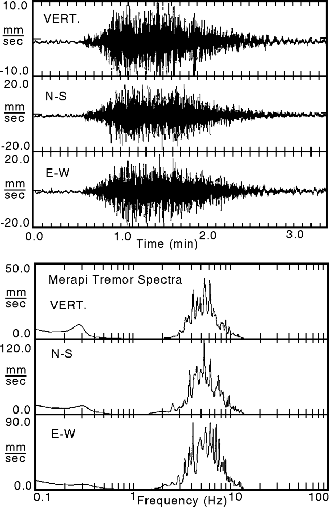 |
Figure 7. Three-component seismic record for Merapi during a large tremor (top). Recorded at Klathakan on 3 June 1993, starting at 1542. Three-component maximum entropy spectral analysis for the seismic record above (bottom). Courtesy of A. Brodscholl and K. Brotopuspito, GMU. |
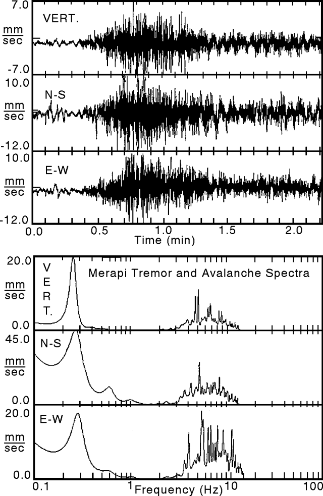 |
Figure 8. Three-component seismic record for Merapi during a tremor and coincident avalanche down the W flank (top). Recorded at Klathakan on 3 June 1993, starting at 1430. Three-component maximum entropy spectral analysis for the seismic record above (bottom). Courtesy of A. Brodscholl and K.S. Brotopuspito, GMU. |
About a week after the rainy season began at the end of November 1993, both the tremor rate and the volume of released gas increased. In early December the amplitudes of volcanic tremor rose to 2-3x higher than in previous months.
As of November the VSI supported seven seismic receiver stations at Merapi and the Geophysical Laboratory of GMU supported three. Most of the stations consisted of a vertical-component seismograph with a 1.0 Hz natural frequency. Starting in April 1993 GMU also studied Merapi using a portable 3-component system with a 0.2 Hz cut-off frequency. The portable system collected good quality data at two sites on Merapi: a) Klathakan, 1.8 km WNW of the summit between 1,200-1,300 m elevation (in the interval 1240-1600, 3 June 1993) and b) At Puncak, 0.5 km N of the summit (in the interval 0730-1530, 14 October 1993).
At Puncak, particle analysis on multiple tremor records revealed azimuths that ranged WSW-SW, occasionally swinging to ESE. From these results researchers suggested two possible tremor sources may lie at depth beneath the summit region: one offset slightly toward the W, another toward the E.
At Klathan the seismic record included intervals with tremor and little other noise (figure 7, top). The seismic record also included an interval of tremor coincident with an avalanche, which tumbled and bounced down the W flanks (figure 8, top). These two different signal sources were characterized using spectral response (figures 7 and 8, bottom); both produced spectra with a broad peak centered near 6 Hz. The broad 6 Hz peak is largest for the case of the tremor. But the case of the coincident tremor and avalanche yielded substantial peaks in the low-frequency range (centered near 0.25 Hz and at or below 0.1 Hz).
On the broad 6-Hz peaks the three components differ slightly, particularly with respect to individual spikes on the peaks. For the case of the tremor without the avalanche (figure 7, bottom), the spikes often correspond between the vertical and N-S horizontal (approximately radial), but the spikes of these components often differ from those on the E-W horizontal (approximately tangential). For the case of the tremor and avalanche, the largest spikes occur mainly to the low-frequency side of the broad peak (figure 8, bottom).
These results suggest that for some cases at Merapi an avalanche accompanied by tremor can be discriminated from tremor alone by looking at the low-frequency content of the signal. Other cases, such as typical earthquakes at Merapi, are not discussed here, but it is conceivable that advancing avalanches can be detected seismically as one means of early warning.
Geological Summary. Merapi, one of Indonesia's most active volcanoes, lies in one of the world's most densely populated areas and dominates the landscape immediately north of the major city of Yogyakarta. It is the youngest and southernmost of a volcanic chain extending NNW to Ungaran volcano. Growth of Old Merapi during the Pleistocene ended with major edifice collapse perhaps about 2,000 years ago, leaving a large arcuate scarp cutting the eroded older Batulawang volcano. Subsequent growth of the steep-sided Young Merapi edifice, its upper part unvegetated due to frequent activity, began SW of the earlier collapse scarp. Pyroclastic flows and lahars accompanying growth and collapse of the steep-sided active summit lava dome have devastated cultivated lands on the western-to-southern flanks and caused many fatalities.
Information Contacts: A. Brodscholl and K. Brotopuspito, GMU; S. Bronto, MVO.