Report on Irazu (Costa Rica) — January 1994
Bulletin of the Global Volcanism Network, vol. 19, no. 1 (January 1994)
Managing Editor: Richard Wunderman.
Irazu (Costa Rica) Fumaroles grow in number, size, and vigor
Please cite this report as:
Global Volcanism Program, 1994. Report on Irazu (Costa Rica) (Wunderman, R., ed.). Bulletin of the Global Volcanism Network, 19:1. Smithsonian Institution. https://doi.org/10.5479/si.GVP.BGVN199401-345060
Irazu
Costa Rica
9.979°N, 83.852°W; summit elev. 3436 m
All times are local (unless otherwise noted)
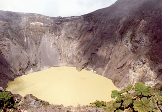
Over the past year a lake covered the bottom of the main crater at Irazú, and in January 1994 fumaroles within it and on the NW flank grew in number, size, and vigor. Overall, reported lake temperatures for January were in the range 18-25°C (ICE); some subaqueous fumarole temperatures reached 40°C, up from near 24°C during previous visits (OVSICORI). In January the lake had a minimum pH of 5, and a color of green to turquoise-green. ICE reported that in late January the temperature and pH of hot and cold springs around the volcano were unchanged. OVSICORI reported Irazú's hottest fumarole temperature, 91°C, on the NW flank.
During 1993, seismicity took the form of sporadic, locally detected earthquakes. The earthquakes typically had magnitudes in the range 1.7-2.2. They were thought to originate along the Irazú fault, which lies within 5 km of the crater. Irazú inflated at a rapid rate during 1991, but it has only deformed a limited amount since then (18:1 & 3). In December and January, dry-tilt measurements, together with leveling and distance surveys, found insignificant changes.
Geological Summary. The massive Irazú volcano in Costa Rica, immediately E of the capital city of San José, covers an area of 500 km2 and is vegetated to within a few hundred meters of its broad summit crater complex. At least 10 satellitic cones are located on its S flank. No lava effusion is known since the eruption of the Cervantes lava flows from S-flank vents about 14,000 years ago, and all known Holocene eruptions have been explosive. The focus of eruptions at the summit crater complex has migrated to the W towards the main crater, which contains a small lake. The first well-documented eruption occurred in 1723, and frequent explosive eruptions have occurred since. Ashfall from the last major eruption during 1963-65 caused significant disruption to San José and surrounding areas. Phreatic activity reported in 1994 may have been a landslide event from the fumarolic area on the NW summit (Fallas et al., 2018).
Information Contacts: E. Fernández, J. Barquero, R. Van der Laat, F. de Obaldia, T. Marino, V. Barboza, and R. Sáenz, OVSICORI; G. Soto, Guillerma E. Alvarado, and Francisco (Chico) Arias, ICE; Héctor (Chopo) Flores, Escuela Centroamericana de Geologia, Univ de Costa Rica.

