Report on Merapi (Indonesia) — October 1994

Bulletin of the Global Volcanism Network, vol. 19, no. 10 (October 1994)
Managing Editor: Richard Wunderman.
Merapi (Indonesia) Pyroclastic flows on 22 November kill at least 41 people on the SSW flank
Please cite this report as:
Global Volcanism Program, 1994. Report on Merapi (Indonesia) (Wunderman, R., ed.). Bulletin of the Global Volcanism Network, 19:10. Smithsonian Institution. https://doi.org/10.5479/si.GVP.BGVN199410-263250
Merapi
Indonesia
7.54°S, 110.446°E; summit elev. 2910 m
All times are local (unless otherwise noted)
Collapse of the active summit dome on 22 November produced pyroclastic block-and-ash flows and glowing surges that traveled SSW up to 7.5 km from the summit (figure 13). As of 28 November, 41 people had died and another 43 were at hospitals in serious condition. All of the victims lived in areas near the banks of the Boyong River. That river flows off Merapi's S flanks and, at ~28 km map distance from the summit, passes through the city of Yogyakarta (population ~50,000). The threats to areas on Merapi's S flank were noted in February 1994, when rockfalls were first observed and reported along the Boyong River. Every month since March, the possibility of SW-flank destruction had been mentioned in Berita Merapi (Merapi News) informing local governments, including Sleman Regency (where this disaster took place), of hazards posed by nuées ardentes. Rockfalls from the dome have recently traveled down the Boyong and other rivers for distances of 500-1,500 m.
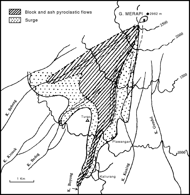 |
Figure 13. Deposits of the Merapi eruption of 22 November 1994 shown on a 500-m-contour base map of the SW quadrant with the primary drainages and some towns labeled. Courtesy of Sukhyar, MVO. |
The eruption was preceded by low-frequency earthquakes on 20 October. Multiphase seismic events and rockfalls continued to be recorded at normal levels, with occasional low-frequency events, but one tremor episode occurred on 3 November. On 4 November this change in seismic behavior was reported to the Chief of Regencies. During 21-22 November, a team from MVO climbed to the summit to observe dome development and to install an extensometer station to measure the offset along cracks.
The first nuée ardente was recorded instrumentally at 1014 on 22 November, and was observed visually from the Plawangan, Ngepos, Babadan, and Jrakah observation posts. The team at the summit saw a vertical plume that originated from a location somewhere on the S part of the dome.
The intensity of the nuées ardentes increased at 1020, prompting the observer at Plawangan to send a warning to the forestry officer at Kaliurang (figure 13), a well-known tourist resort. The officer then yelled a warning to the local people. Five minutes later (1025) MVO instructed all observation posts and radio stations of the Regional Task Force that the alert status had been raised to the highest level (Level 4), and that evacuations should begin. At 1045 the observer at Plawangan sent a message to the Chief of Pakem District, but he was already in the field, probably because he had heard the previous warning. Another evacuation warning was radioed to regional task forces at 1100. By 1215 the first victim had been discovered. The Plawangan observation post was abandoned at 1508 and the personnel temporarily moved to Kaliurang. The nuées ardentes had diminished by 1720 that evening.
A NOAA/NESDIS volcano hazards alert stated that at 1346 on 22 November a plume rose to ~10 km. At that time winds aloft were toward the W at 18 km/hour. These same points were repeated in an aviation safety alert (NOTAM).
A UNDHA report on 23 November stated that 25 of 40 employees building a water treatment facility were still missing, while 15 were found dead. Evacuees totalled 6,026 from the neighboring villages in the subdistrict of Pakem. Evacuation and emergency response measures had been undertaken by the local authorities and community members. The UNDHA reported that local volcanology officials advised authorities and local people to remain on alert for seven days.
A 23 November Tokyo Kyodo broadcast (in English) reported "Indonesia's team for disaster safety in Yogjakarta said ash rain has reached Temanggung, ~45 km NW of Merapi." A UPI news report stated that, on the morning of 23 November, an official of the natural disasters office in Sleman said that 118 people were in three hospitals suffering from serious burns. The report further stated that "hundreds of homes have collapsed and thousands of cattle were buried by ash." On 26 November UPI reported that >4,700 people remained in evacuation centers.
According to press accounts and other information collected by the U.S. Embassy and issued on 23 and 25 November, most of the casualties occurred when superheated gases swept through two small villages (Desa Purwobinangun and Desa Hargobinangun in the Sleman district). The eruption ignited ~500 hectares of rainforest near Kaliurang, which press reports said had been damaged by ashfall. Embassy reports on 25 November stated that an estimated 34-200 people were still missing (there had been no communication with some affected villages on the slopes of the volcano). Well over 500 injured persons had been treated at local hospitals. The 25 November Embassy report said that "Local authorities are now concerned about an accumulation of volcanic material [on Merapi's flanks]. It is feared that the approaching rainy season could dislodge this material (estimated in the range of 11 million m3) causing dangerous [mudflows] in the villages below. City officials in Yogyakarta . . . are reported to be constructing a third catchment dam to regulate volcanic material entering the Code river, which runs through the city."
A 23 November Reuters press report stated that "The official Antara news agency said that despite warnings, local people were reluctant to leave the area, regarding the volcano as sacred and likely to offer some supernatural signs if it were to cause a major disaster."
Geological Summary. Merapi, one of Indonesia's most active volcanoes, lies in one of the world's most densely populated areas and dominates the landscape immediately north of the major city of Yogyakarta. It is the youngest and southernmost of a volcanic chain extending NNW to Ungaran volcano. Growth of Old Merapi during the Pleistocene ended with major edifice collapse perhaps about 2,000 years ago, leaving a large arcuate scarp cutting the eroded older Batulawang volcano. Subsequent growth of the steep-sided Young Merapi edifice, its upper part unvegetated due to frequent activity, began SW of the earlier collapse scarp. Pyroclastic flows and lahars accompanying growth and collapse of the steep-sided active summit lava dome have devastated cultivated lands on the western-to-southern flanks and caused many fatalities.
Information Contacts: Sukhyar, MVO; SAB; UNDHA; AP; Reuters; UPI; ANS.