Report on Krakatau (Indonesia) — December 1994
Bulletin of the Global Volcanism Network, vol. 19, no. 12 (December 1994)
Managing Editor: Richard Wunderman.
Krakatau (Indonesia) Ash eruptions in October-December seen by pilots
Please cite this report as:
Global Volcanism Program, 1994. Report on Krakatau (Indonesia) (Wunderman, R., ed.). Bulletin of the Global Volcanism Network, 19:12. Smithsonian Institution. https://doi.org/10.5479/si.GVP.BGVN199412-262000
Krakatau
Indonesia
6.1009°S, 105.4233°E; summit elev. 285 m
All times are local (unless otherwise noted)
A pilot on a 16 October Qantas Airlines flight enroute from Perth to Singapore reported a light-gray, moderately dense, mushroom-shaped ash cloud rising to ~2 km altitude and drifting ~55 km W from the summit. Another pilot report on 28 November noted ash from the volcano rising to ~3 km altitude. A similar report on 18 December stated that an ash cloud was as high as 3 km and drifting E.
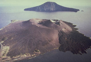
On 26 July 1994, J. Sesiano made observations from the sea, from the summit of the 1930 peak, and from the slopes of the active cone. Activity consisted of violent explosions (averaging one every 15 minutes) with ejecta (small tephra and bombs) erupted vertically to heights of 100-200 m that fell back into the crater. Finer particles were blown NW by winds. Longer intervals between eruptions (30-45 minutes) were followed by a single or series of very strong explosions that generated a dark plume 1,000-1,500 m above the crater. Ejecta from these stronger explosions, including some bombs >1 m3 in size, fell over the entire cone. Boulders were seen rolling down the slopes, reaching and slowly burying the November 1992-Apr 1993 lava flow (18:07), which had a surface temperature of ~30°C and was still degassing.
A rough examination was done on two thin sections made from fresh lava samples (collected while still hot). Phenocrysts were mostly zoned plagioclase, some augite, and rare olivine with reaction rims. The groundmass consisted of fine-grained opaque grains and scattered plagioclase, but no glass. Plagioclase composition, determined from very few properly oriented crystals, was An$45-55. Based on these observations, the samples were identified as andesite to basaltic andesite.
Geological Summary. The renowned Krakatau (frequently mis-named as Krakatoa) volcano lies in the Sunda Strait between Java and Sumatra. Collapse of an older edifice, perhaps in 416 or 535 CE, formed a 7-km-wide caldera. Remnants of that volcano are preserved in Verlaten and Lang Islands; subsequently the Rakata, Danan, and Perbuwatan cones were formed, coalescing to create the pre-1883 Krakatau Island. Caldera collapse during the catastrophic 1883 eruption destroyed Danan and Perbuwatan, and left only a remnant of Rakata. This eruption caused more than 36,000 fatalities, most as a result of tsunamis that swept the adjacent coastlines of Sumatra and Java. Pyroclastic surges traveled 40 km across the Sunda Strait and reached the Sumatra coast. After a quiescence of less than a half century, the post-collapse cone of Anak Krakatau (Child of Krakatau) was constructed within the 1883 caldera at a point between the former Danan and Perbuwatan cones. Anak Krakatau has been the site of frequent eruptions since 1927.
Information Contacts: J. Sesiano and J. Bertrand, Univ de Genéve; BOM Darwin, Australia; T. Fox, ICAO.

